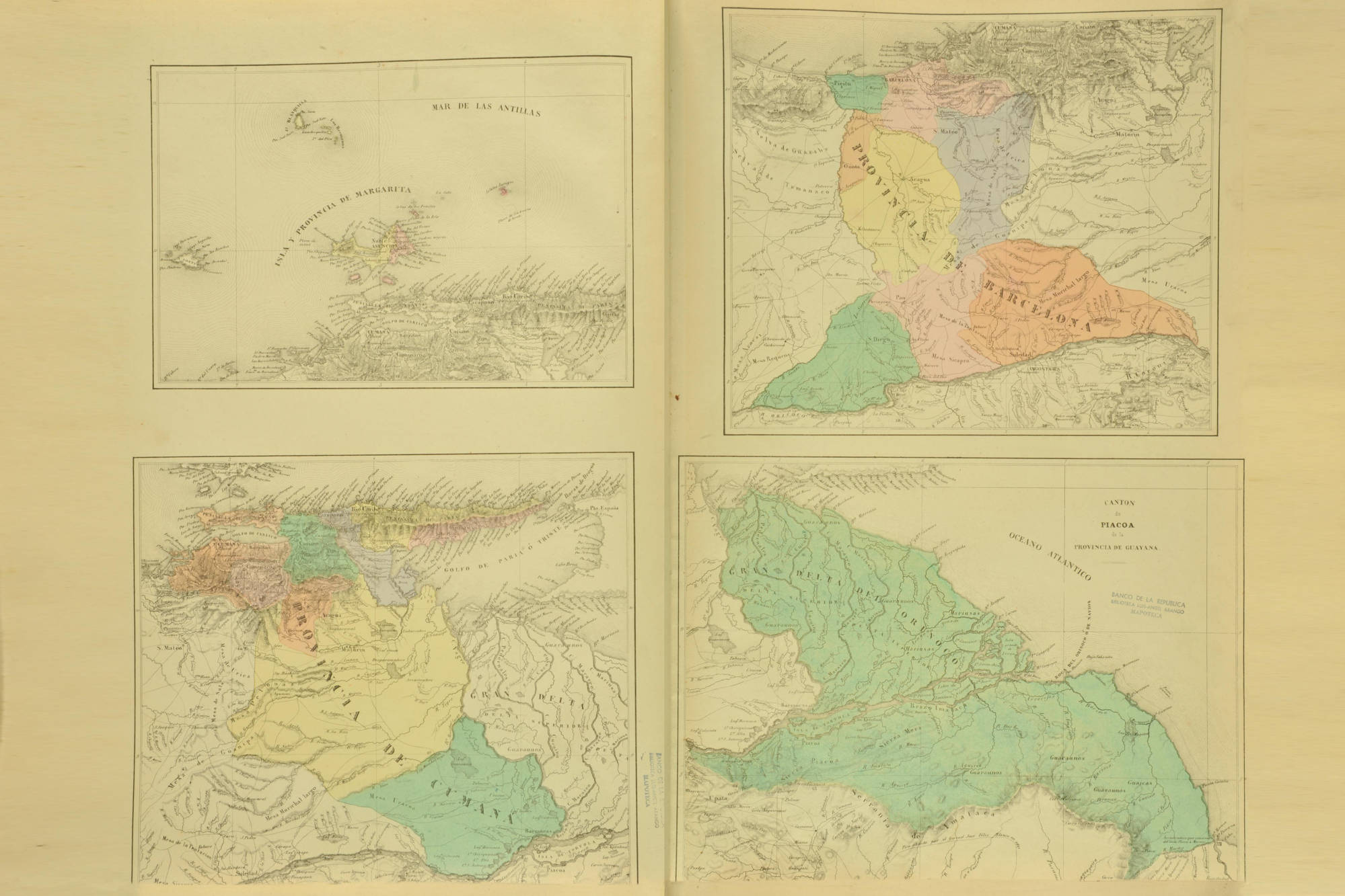
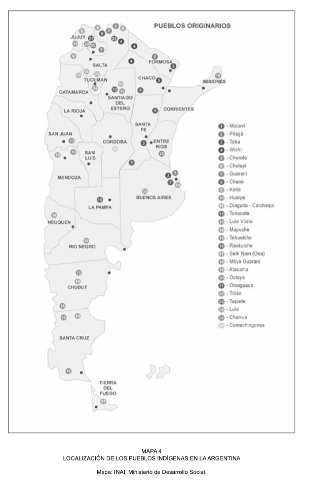
Dispossesions in the Americas

Dispossesions in the Americas

  • Lar
  • Explorar
  • Autores
  • Sobre
  • Arte
  • Corpos
  • Currículos
  • Patrimônio Cultural
  • Mapas
  • Territórios
Voltar à seção Explorar

Lendo em Inglês

Mapa 1840

CANTON de PIACOA de la PROVINCIA DE GUAYANA

  • CODAZZI;AGUSTIN

Publicado: 1840

  • Baixar Imagem
  • Baixar Imagem

Lendo em Espanhol

Mapa 1840

CANTON de PIACOA de la PROVINCIA DE GUAYANA

  • CODAZZI;AGUSTIN

Publicado: 1840

  • Baixar Imagem
  • Baixar Imagem
Mapa 1840

CANTON de PIACOA de la PROVINCIA DE GUAYANA

  • CODAZZI;AGUSTIN

Publicado: 1840

  • Baixar Imagem

Povos

  • GUARUANA
  • MARIUSA
  • GUAICAS

Citação

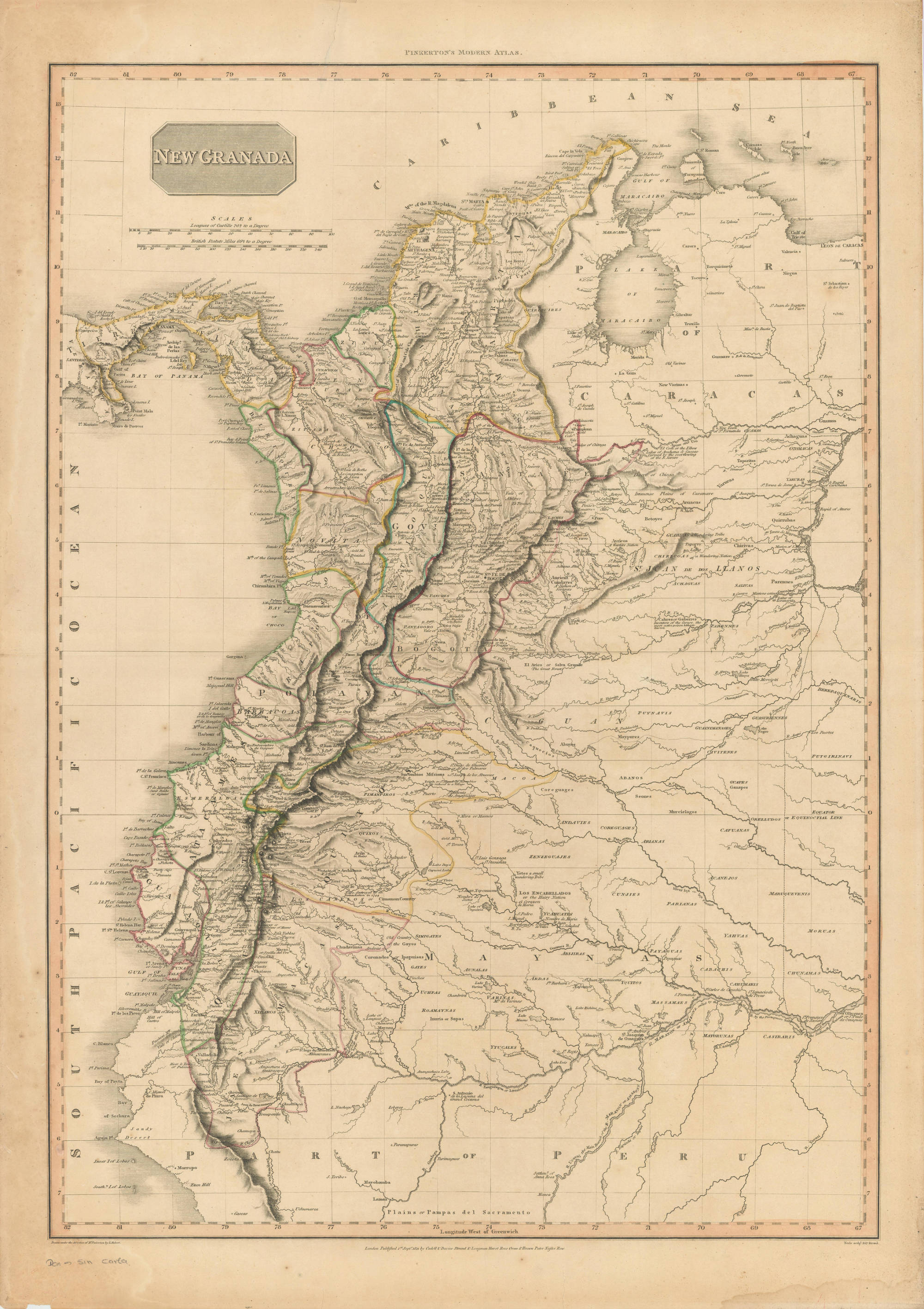
Codazzi;Agustín. "Carta que contiene las Provincias de Barcelona;Cumaná y Margarita divididas por cantones." Map. 1840. Accessed January 22;2023. https://babel.banrepcultural.org/digital/collection/p17054coll13/id/57/rec/12.

  • Baixar Imagem

Itens Relacionados

Distribución Territorial
Actual del Pueblo Yagan. XXII Region de Magallanes y la Antártica Chile

Distribución Territorial Actual del Pueblo Yagan. XXII Region de Magallanes y la Antártica Chile

Mapa 1993
Carta para la inteligencia del informe sobre fronteras presentado al Excelentísimo Gobierno nacional por el General Don Wenceslao Paunero. Impreso

Carta para la inteligencia del informe sobre fronteras presentado al Excelentísimo Gobierno nacional por el General Don Wenceslao Paunero. Impreso

Mapa 1850 - 1880
Map of Tenango (Valley of Mexico), 1587, Archivo General de la Nación, no. 1822

Map of Tenango (Valley of Mexico), 1587, Archivo General de la Nación, no. 1822

Mapa 1587
Movilizaciones indígenas, mapas e historias por la propiedad de la tierra en el chaco argentino. La lucha de las familias tobas por poxoŷaxaic alhua.

Movilizaciones indígenas, mapas e historias por la propiedad de la tierra en el chaco argentino. La lucha de las familias tobas por poxoŷaxaic alhua.

Mapa 2004
A Map of part of Yucatan or of that Part of the Eastern Shore Within the Bay of Honduras Alloted to Great Britain for the Cutting of Logwood, in consequence of the Convention Signed with Spain on the 14th July 1786.

A Map of part of Yucatan or of that Part of the Eastern Shore Within the Bay of Honduras Alloted to Great Britain for the Cutting of Logwood, in consequence of the Convention Signed with Spain on the 14th July 1786.

Mapa 1700
NEW GRANADA

NEW GRANADA

Mapa 1811
LENGUAS INDIGENAS AMAZONIA

LENGUAS INDIGENAS AMAZONIA

Mapa 2008
Serie Chomos voladores [Chomos voadores]

Serie Chomos voladores [Chomos voadores]

Obra de arte

Despossessões nas Américas

Um projeto de

University of Pennsylvania

Copyright 2024

Com o apoio de

Mellon Foundation

Projeto e desenvolvimento do site

Element 84

Créditos da arte

Codazzi;Agustín. “Carta que contiene las Provincias de Barcelona;Cumaná y Margarita divididas por cantones.” Map. 1840. Accessed January 22;2023. https://babel.banrepcultural.org/digital/collection/p17054coll13/id/57/rec/12.

Páginas do site

  • Lar
  • Explorar
  • Autores
  • Sobre
  • Arte
  • Corpos
  • Currículos
  • Patrimônio Cultural
  • Mapas
  • Territórios