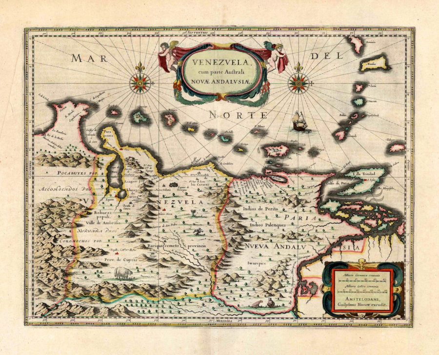
Dispossesions in the Americas

Dispossesions in the Americas

  • Lar
  • Explorar
  • Autores
  • Sobre
  • Arte
  • Corpos
  • Currículos
  • Patrimônio Cultural
  • Mapas
  • Territórios
Voltar à seção Explorar

Lendo em Inglês

Mapa 1630

Venezuela;cum parte Australi Novae Andalusiae

  • BLAEU;WILLEM JANSZOON;ET AL.

Publicado: 1647

  • Baixar Imagem
  • Baixar Imagem

Lendo em Espanhol

Mapa 1630

Venezuela;cum parte Australi Novae Andalusiae

  • BLAEU;WILLEM JANSZOON;ET AL.

Publicado: 1647

  • Baixar Imagem
  • Baixar Imagem
Mapa 1630

Venezuela;cum parte Australi Novae Andalusiae

  • BLAEU;WILLEM JANSZOON;ET AL.

Publicado: 1647

  • Baixar Imagem

Povos

  • PALENQUES
  • KAKETIO
  • ACHAGUA
  • BOBURES
  • COROMOCHOS
  • POCABUYES

Citação

Blaeu;Willem Janszoon;and Joan Blaeu. Venezuela;cum parte Australi Novae Andalusiae. Map. Amsterdam;Netherlands: Blaeu Printing House;1647. Accessed March 13;2022. https://sanderusmaps.com/our-catalogue/antique-maps/america/south-america/old-antique-map-of-venezuela-by-willem-joan-blaeu-26853.

  • Baixar Imagem

Itens Relacionados

What did they actually see? [O que é que eles viram realmente?] “Out of control” Pag-127 / “Deviant” Pag-128 / “Possessed” Pag-129 2018

What did they actually see? [O que é que eles viram realmente?] “Out of control” Pag-127 / “Deviant” Pag-128 / “Possessed” Pag-129 2018

Obra de arte
CARACCAS AND GUIANA

CARACCAS AND GUIANA

Mapa 1814
Croquis IV. La región litoral ecuatoriana (Moreno Yanez;1989;2)

Croquis IV. La región litoral ecuatoriana (Moreno Yanez;1989;2)

Mapa -500 - 1530
An exact draught of the river of Bellese as high as the Barcadares. A new draught of the bay of Honduras by Capt. Nathaniel Uring

An exact draught of the river of Bellese as high as the Barcadares. A new draught of the bay of Honduras by Capt. Nathaniel Uring

Mapa 1726
Paraguay;ó prov. de Rio de la Plata cum regionibus adiacentibus Tucuman et Sta. Cruz de la Sierra

Paraguay;ó prov. de Rio de la Plata cum regionibus adiacentibus Tucuman et Sta. Cruz de la Sierra

Mapa 1600 - 1699
ARCHEOLOGICAL MAP OF MIDDLE AMERICA

ARCHEOLOGICAL MAP OF MIDDLE AMERICA

Mapa 1968
Mexico at the Time of the Conquest

Mexico at the Time of the Conquest

Mapa 1519
PUEBLO AMAHUACA

PUEBLO AMAHUACA

Mapa 2021

Despossessões nas Américas

Um projeto de

University of Pennsylvania

Copyright 2024

Com o apoio de

Mellon Foundation

Projeto e desenvolvimento do site

Element 84

Créditos da arte

Blaeu;Willem Janszoon;and Joan Blaeu. Venezuela;cum parte Australi Novae Andalusiae. Map. Amsterdam;Netherlands: Blaeu Printing House;1647. Accessed March 13;2022. https://sanderusmaps.com/our-catalogue/antique-maps/america/south-america/old-antique-map-of-venezuela-by-willem-joan-blaeu-26853.

Páginas do site

  • Lar
  • Explorar
  • Autores
  • Sobre
  • Arte
  • Corpos
  • Currículos
  • Patrimônio Cultural
  • Mapas
  • Territórios