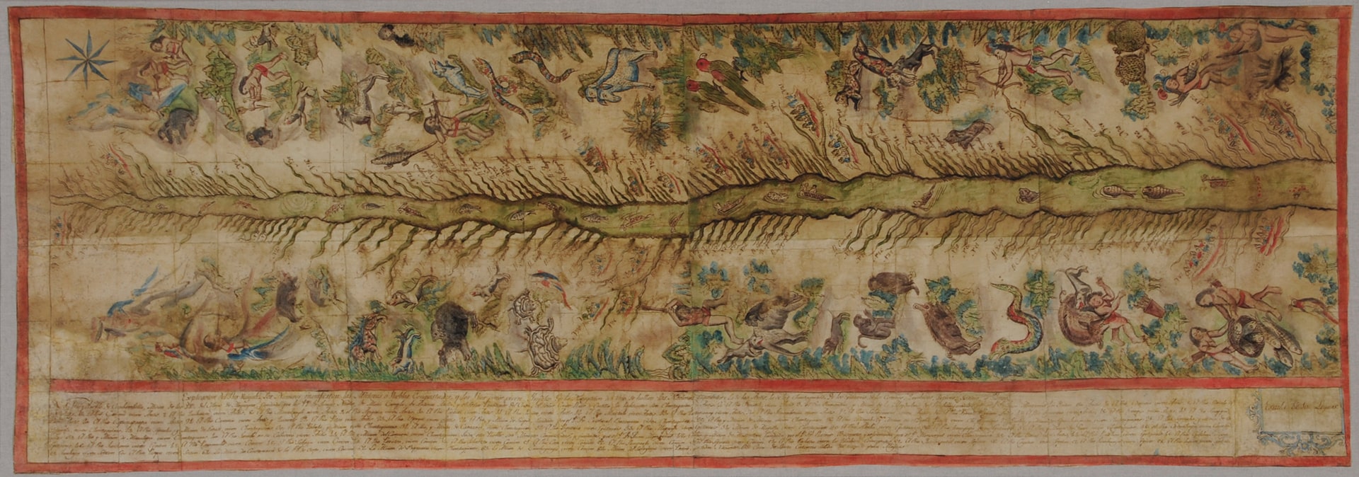
Dispossesions in the Americas

Dispossesions in the Americas

  • Lar
  • Explorar
  • Autores
  • Sobre
  • Arte
  • Corpos
  • Currículos
  • Patrimônio Cultural
  • Mapas
  • Territórios
Voltar à seção Explorar

Lendo em Inglês

Mapa 1808 - 1812

Map of the Ucayali River

  • FRANCISCAN MISSIONARIES;INDIGENOUS ARTISTS

Publicado: 1812

  • Baixar Imagem
  • Baixar Imagem

Lendo em Espanhol

Mapa 1808 - 1812

Map of the Ucayali River

  • FRANCISCAN MISSIONARIES;INDIGENOUS ARTISTS

Publicado: 1812

  • Baixar Imagem
  • Baixar Imagem
Mapa 1808 - 1812

Map of the Ucayali River

  • FRANCISCAN MISSIONARIES;INDIGENOUS ARTISTS

Publicado: 1812

  • Baixar Imagem

Povos

  • ANTI
  • CASHIBO
  • CHONTAQUIRO
  • CONIBO
  • IPITINERI
  • PANOBO
  • SHETIBO
  • SHIPIBO

Citação

The Hispanic Society (New York), Viceregal Peru, Map of the Ucayali River. https://hispanicsociety.org/exhibition/current-exhibitions-works-on-loan/treasures-on-the-terrace_highlights-from-the-hispanic-society-museum-and-library/ucayali-river/

  • Baixar Imagem

Itens Relacionados

CARTE DE LA CAPITAINERIE GENERALE DE CARACAS Comprenant les Provinces de Venezuela;Maracaibo;Varinas;Cumana;la Guiane;et Isle de la Margeurite;Pour servir au Voyage a la partie oriental de la Terre Ferme dans l'Amerique Meridionale

CARTE DE LA CAPITAINERIE GENERALE DE CARACAS Comprenant les Provinces de Venezuela;Maracaibo;Varinas;Cumana;la Guiane;et Isle de la Margeurite;Pour servir au Voyage a la partie oriental de la Terre Ferme dans l'Amerique Meridionale

Mapa 1801 - 1805
Carte particulière des costes de la Capitainerie de Siara au Brésil

Carte particulière des costes de la Capitainerie de Siara au Brésil

Mapa 1700 - 1750
Maya Communal Lands, Reservations, and Logging Concessions

Maya Communal Lands, Reservations, and Logging Concessions

Mapa 1997
Obispado de Tlaxcala

Obispado de Tlaxcala

Mapa 1500 - 1599
1. Angustia #1
2. Angustia #2
3. Angustia #7
4. Angustia #8
5. Angustia #10
6. Angustia #12´
[Angústia]

1. Angustia #1 2. Angustia #2 3. Angustia #7 4. Angustia #8 5. Angustia #10 6. Angustia #12´ [Angústia]

Obra de arte
Sistema guatemalteco de áreas protegidas (SIGAP) y sitios arqueológicos en 2000.

Sistema guatemalteco de áreas protegidas (SIGAP) y sitios arqueológicos en 2000.

Mapa 2000
Croquis V. La región amazónica ecuatoriana (Moreno Yanez;1989;2)

Croquis V. La región amazónica ecuatoriana (Moreno Yanez;1989;2)

Mapa -500 - 1530
MÉXICO

MÉXICO

Mapa 2015

Despossessões nas Américas

Um projeto de

University of Pennsylvania

Copyright 2024

Com o apoio de

Mellon Foundation

Projeto e desenvolvimento do site

Element 84

Créditos da arte

The Hispanic Society (New York), Viceregal Peru, Map of the Ucayali River. https://hispanicsociety.org/exhibition/current-exhibitions-works-on-loan/treasures-on-the-terrace_highlights-from-the-hispanic-society-museum-and-library/ucayali-river/

Páginas do site

  • Lar
  • Explorar
  • Autores
  • Sobre
  • Arte
  • Corpos
  • Currículos
  • Patrimônio Cultural
  • Mapas
  • Territórios