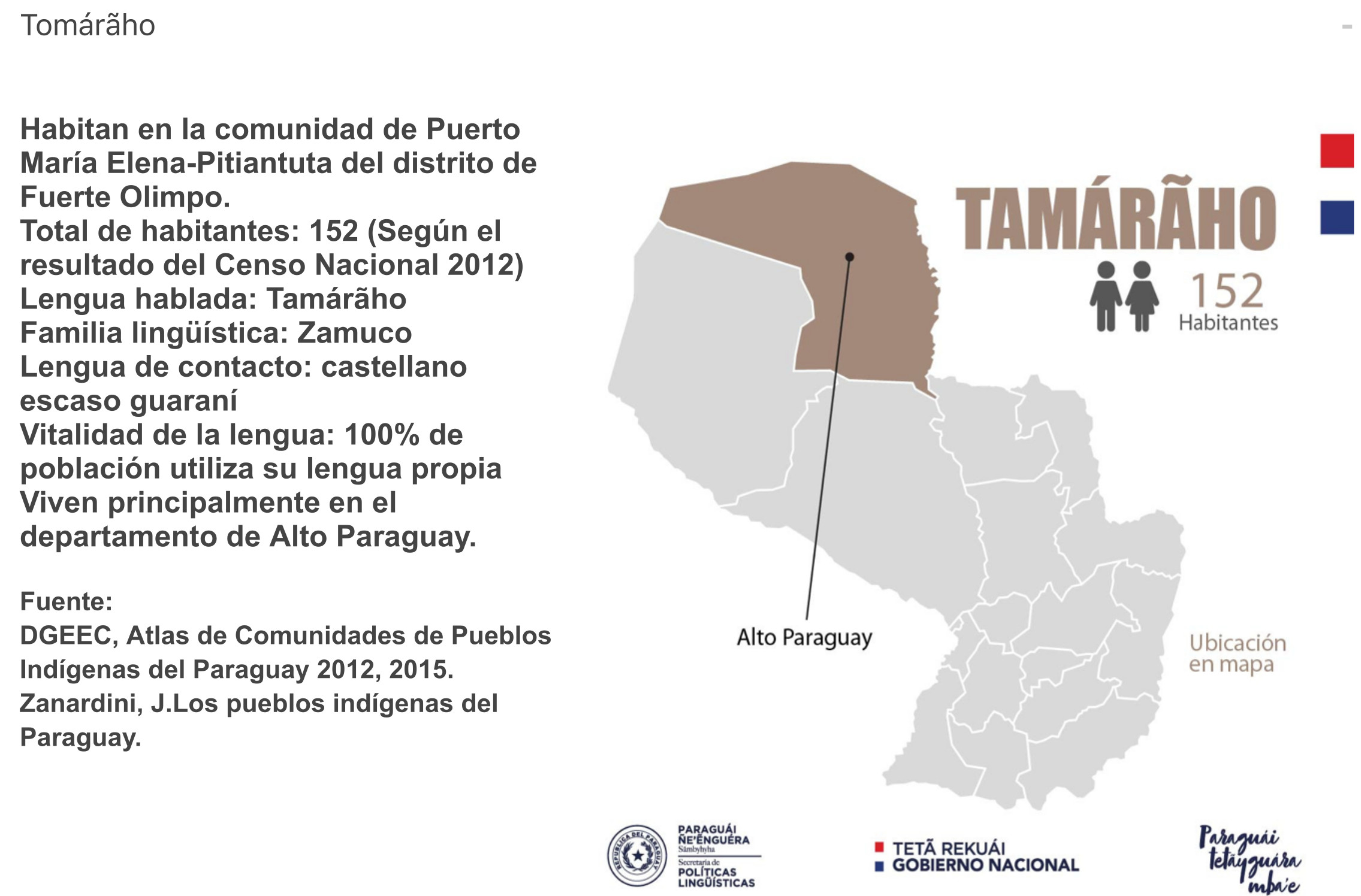
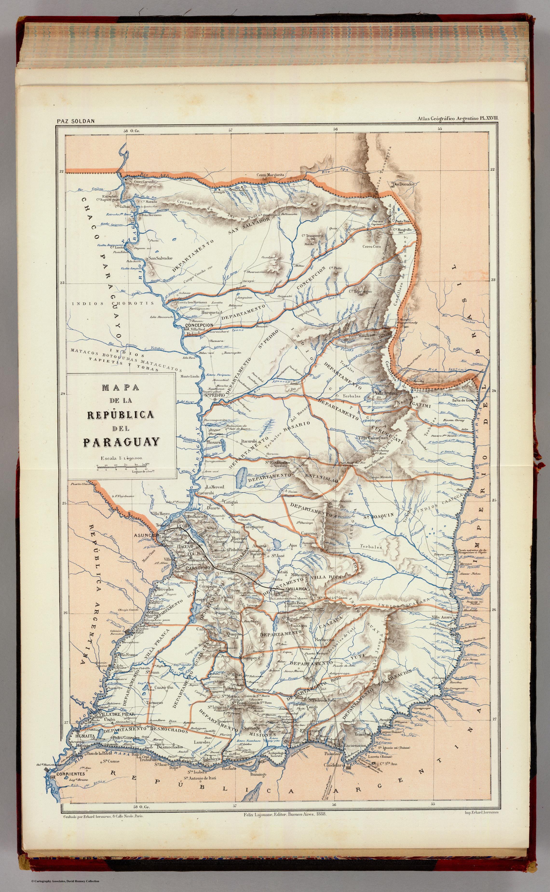
Dispossesions in the Americas

Dispossesions in the Americas

  • Lar
  • Explorar
  • Autores
  • Sobre
  • Arte
  • Corpos
  • Currículos
  • Patrimônio Cultural
  • Mapas
  • Territórios
Voltar à seção Explorar

Lendo em Inglês

Mapa 1888

MAPA DE LA REPÚBLICA DEL PARAGUAY

  • PAZ SOLDAN, MARIANO FELIPE

Publicado: 1888

  • Baixar Imagem
  • Baixar Imagem

Lendo em Espanhol

Mapa 1888

MAPA DE LA REPÚBLICA DEL PARAGUAY

  • PAZ SOLDAN, MARIANO FELIPE

Publicado: 1888

  • Baixar Imagem
  • Baixar Imagem
Mapa 1888

MAPA DE LA REPÚBLICA DEL PARAGUAY

  • PAZ SOLDAN, MARIANO FELIPE

Publicado: 1888

  • Baixar Imagem

Povos

  • CHOROTE
  • MATACO
  • BOTOGUDAS
  • TAPIETE
  • TOBA
  • GUAYNGUA
  • CAAYGUA
  • PAI TAVYTERA
  • GUYANA
  • ACHE

Citação

Paz Soldan, Mariano Felipe. Mapa de la República del Paraguay. Map. Buenos Aires: Felix Lajouane, 1888. Accessed April 25, 2023. https://www.davidrumsey.com/luna/servlet/detail/RUMSEY~8~1~20660~570037:Mapa-de-la-Republica-del-Paraguay-?sort=pub_list_no_initialsort%2Cpub_date%2Cpub_list_no%2Cseries_no.

  • Baixar Imagem

Itens Relacionados

Fig. 1 Map of the Guianas with schematic locations of the
indigenous groups relevant to our study, based on the linguistic
map of South America (http://www.muturzikin.com/cartesamerique/
7.htm). Carib-speaking groups are indicated in yellow, Arawak-speaking
groups in blue, Tupi-speaking Wayãpi in pink and the Warao-speaking
group in green

Fig. 1 Map of the Guianas with schematic locations of the indigenous groups relevant to our study, based on the linguistic map of South America (http://www.muturzikin.com/cartesamerique/ 7.htm). Carib-speaking groups are indicated in yellow, Arawak-speaking groups in blue, Tupi-speaking Wayãpi in pink and the Warao-speaking group in green

Mapa 2000 - 2024
TAMÁRÃHO

TAMÁRÃHO

Mapa 2015
Mauricio

Mauricio

Obra de arte
Mapa de Magallanes

Mapa de Magallanes

Mapa 1746
SOUTH AMERICA - NORTHERN SECTION

SOUTH AMERICA - NORTHERN SECTION

Mapa 1923
PUEBLO VACACOCHA

PUEBLO VACACOCHA

Mapa 2021
MAP OF NEW GRANADA

MAP OF NEW GRANADA

Mapa 1864
Paraguay, Ó Prov. De Rio De La Plata cum regionibus adiacentibus Tvcvman et Sta. Crvz De La Sierra.

Paraguay, Ó Prov. De Rio De La Plata cum regionibus adiacentibus Tvcvman et Sta. Crvz De La Sierra.

Mapa 1600 - 1650

Despossessões nas Américas

Um projeto de

University of Pennsylvania

Copyright 2024

Com o apoio de

Mellon Foundation

Projeto e desenvolvimento do site

Element 84

Créditos da arte

Paz Soldan, Mariano Felipe. Mapa de la República del Paraguay. Map. Buenos Aires: Felix Lajouane, 1888. Accessed April 25, 2023. https://www.davidrumsey.com/luna/servlet/detail/RUMSEY~8~1~20660~570037:Mapa-de-la-Republica-del-Paraguay-?sort=pub_list_no_initialsort%2Cpub_date%2Cpub_list_no%2Cseries_no.

Páginas do site

  • Lar
  • Explorar
  • Autores
  • Sobre
  • Arte
  • Corpos
  • Currículos
  • Patrimônio Cultural
  • Mapas
  • Territórios