Dispossesions in the Americas

Dispossesions in the Americas

  • Lar
  • Explorar
  • Autores
  • Sobre
  • Arte
  • Corpos
  • Currículos
  • Patrimônio Cultural
  • Mapas
  • Territórios
Voltar à seção Explorar

Lendo em Inglês

Mapa 1883

Map of Guatemala/to illustrate/Mr. A.P Maudslay's Paper

  • WELLER, EDWARD

Publicado: 1883

  • Baixar Imagem
  • Baixar Imagem

Lendo em Espanhol

Mapa 1883

Map of Guatemala/to illustrate/Mr. A.P Maudslay's Paper

  • WELLER, EDWARD

Publicado: 1883

  • Baixar Imagem
  • Baixar Imagem
Mapa 1883

Map of Guatemala/to illustrate/Mr. A.P Maudslay's Paper

  • WELLER, EDWARD

Publicado: 1883

  • Baixar Imagem

Citação

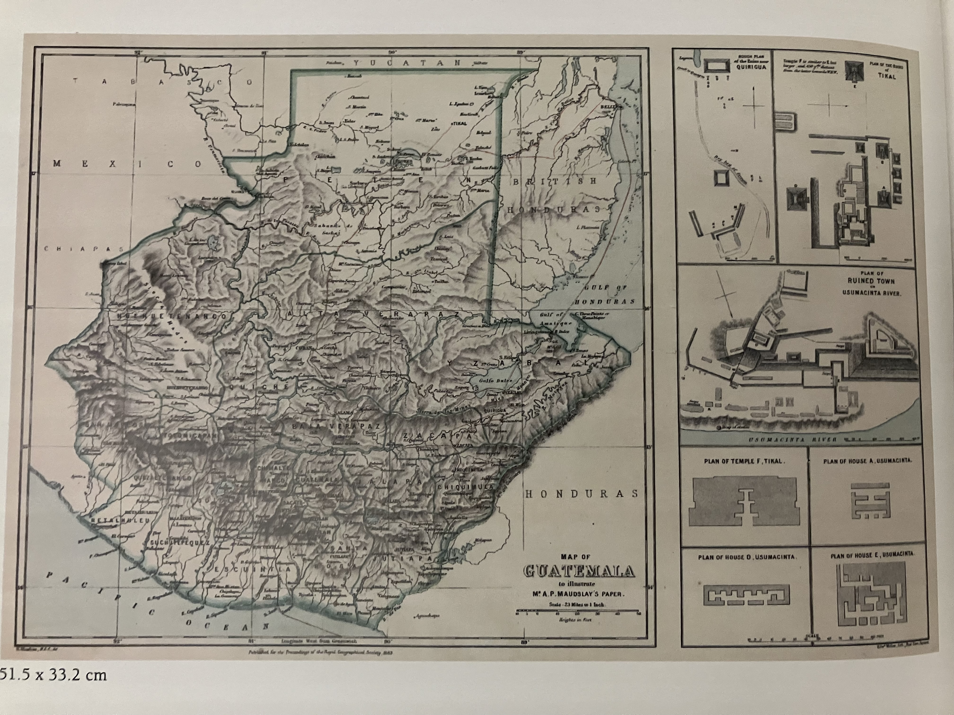
Weller, Edward "Map of Guatemala/to illustrate/Mr. A.P Maudslay's Paper. Royal Geographical Society, London, 1883. IN Jens P. Bornholt and William H. Hempstead (eds) Cuatro Siglios de Expresiones Geográficas del Istmo Centroamericano: 1500-1900. Fundacion Uno: Universidad Francisco Marroquin, Guatemala, 2007.

  • Baixar Imagem

Itens Relacionados

Mapa de Ubicacion de Grupos y Pueblos Indigenas en Aislamiento Voluntario

Mapa de Ubicacion de Grupos y Pueblos Indigenas en Aislamiento Voluntario

Mapa 2010
PUEBLO KANDOZI

PUEBLO KANDOZI

Mapa 2021
TAMÁRÃHO

TAMÁRÃHO

Mapa 2015
"Pueblos Indígenas de Costa Rica"

"Pueblos Indígenas de Costa Rica"

Mapa 2010
Grupos étnicos al contacto con Humboldt (1800-1810)

Grupos étnicos al contacto con Humboldt (1800-1810)

Mapa 1800 - 1810
CHART containing the greater part of the SOUTH SEA to the South of the LINE, with the ISLANDS dispersed thro' the same

CHART containing the greater part of the SOUTH SEA to the South of the LINE, with the ISLANDS dispersed thro' the same

Mapa 1794
Efeitos do garimpo
no território Omágua São Paulo de Olivença-AM

Efeitos do garimpo no território Omágua São Paulo de Olivença-AM

Mapa 2000 - 2099
Distribución histórica de las poblaciones indígenas según la familia lingüística

Distribución histórica de las poblaciones indígenas según la familia lingüística

Mapa 1490

Despossessões nas Américas

Um projeto de

University of Pennsylvania

Copyright 2024

Com o apoio de

Mellon Foundation

Projeto e desenvolvimento do site

Element 84

Créditos da arte

Weller, Edward “Map of Guatemala/to illustrate/Mr. A.P Maudslay’s Paper. Royal Geographical Society, London, 1883. IN Jens P. Bornholt and William H. Hempstead (eds) Cuatro Siglios de Expresiones Geográficas del Istmo Centroamericano: 1500-1900. Fundacion Uno: Universidad Francisco Marroquin, Guatemala, 2007.

Páginas do site

  • Lar
  • Explorar
  • Autores
  • Sobre
  • Arte
  • Corpos
  • Currículos
  • Patrimônio Cultural
  • Mapas
  • Territórios