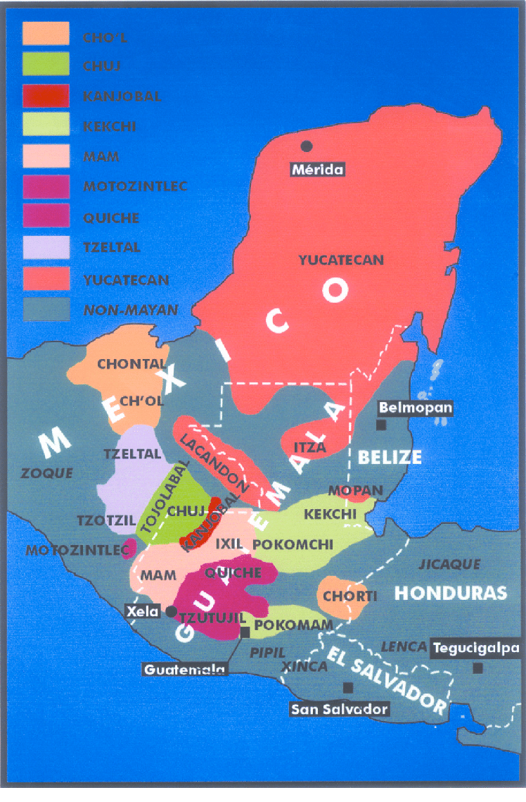
Dispossesions in the Americas

Dispossesions in the Americas

  • Lar
  • Explorar
  • Autores
  • Sobre
  • Arte
  • Corpos
  • Currículos
  • Patrimônio Cultural
  • Mapas
  • Territórios
Voltar à seção Explorar

Lendo em Inglês

Mapa

Origin of Mayans according to HLA genes and the uniqueness

  • GOMEZ-CASADO, EDUARDO, ET AL.

Publicado: 2003

  • Baixar Imagem
  • Baixar Imagem

Lendo em Espanhol

Mapa

Origin of Mayans according to HLA genes and the uniqueness

  • GOMEZ-CASADO, EDUARDO, ET AL.

Publicado: 2003

  • Baixar Imagem
  • Baixar Imagem
Mapa

Origin of Mayans according to HLA genes and the uniqueness

  • GOMEZ-CASADO, EDUARDO, ET AL.

Publicado: 2003

  • Baixar Imagem

Povos

  • YUCATECAN
  • CHONTAL
  • CHOL
  • ITZA
  • LANCANDON
  • TZELTAL
  • ZOQUE
  • TZOTZIL
  • TOJOLABAL
  • CHUJ
  • MOTOZINTLEC
  • KANJOBAL
  • MAM
  • IXIL
  • MOPAN
  • KEKCHI
  • POKOMCHI
  • QUICHE
  • TZUTUJIL
  • POKOMAM
  • CHORTI
  • PIPIL
  • XINCA
  • JICAQUE
  • LENCA

Citação

Gomez-Casado, Eduardo, Jorge Martinez-Laso, Juan Moscoso del Prado Ucelay, Joseph Zamora, José M. Martin-Villa, Mercedes Perez-Blas, Mercedes Lopez-Santalla, P. Lucas Gramajo, Carlos Silvera, Ernesto Lowy, and Antonio Arnaiz-Villena. "Origin of Mayans according to HLA genes and the uniqueness of Amerindians." Research Gate. Last modified July 2003. Accessed October 2, 2021. https://www.researchgate.net/figure/Map-showing-the-geographic-location-of-the-Mayan-population-studied-and-Mayan-languages_fig1_10693028.

  • Baixar Imagem

Itens Relacionados

Los quichuas de la Sierra

Los quichuas de la Sierra

Mapa 1997
Carte de la Guyane française (2ème édition). Service géographique des colonies. [Feuille 1]

Carte de la Guyane française (2ème édition). Service géographique des colonies. [Feuille 1]

Mapa 1926
Carte de la Goÿanne francoise depuis le fort de Barou et la Rre. D'yari, jusqua Maroni ou on voit les principaux établissements des Francois tant das l'isle de Caÿenne que dans la terre ferme, avec les noms des nations indienne qui habitent et les missions que le RR.PP y ont établies.

Carte de la Goÿanne francoise depuis le fort de Barou et la Rre. D'yari, jusqua Maroni ou on voit les principaux établissements des Francois tant das l'isle de Caÿenne que dans la terre ferme, avec les noms des nations indienne qui habitent et les missions que le RR.PP y ont établies.

Mapa 1741
NÚMERO DE INDIOS EN LAS SUBDELEGACIONES EN 1800

NÚMERO DE INDIOS EN LAS SUBDELEGACIONES EN 1800

Mapa 1800
APPROXIMATE BORDERS OF TERRITORY OF THE AYMARA POLITY KARANQAS (OR CARANGAS) IN THE 19TH CENTURY

APPROXIMATE BORDERS OF TERRITORY OF THE AYMARA POLITY KARANQAS (OR CARANGAS) IN THE 19TH CENTURY

Mapa 1894
Tawahka homeland, 1916: Showing Río Wampú (Wanpo), Río Patuca (Butuk), Cerro Quigungun (Wangkibila Volc [anol]), and the first cartographical rendering of Krautara (Moravian Archives, Bethlehem, Pennsylvania, Heath 1916)

Tawahka homeland, 1916: Showing Río Wampú (Wanpo), Río Patuca (Butuk), Cerro Quigungun (Wangkibila Volc [anol]), and the first cartographical rendering of Krautara (Moravian Archives, Bethlehem, Pennsylvania, Heath 1916)

Mapa 1916
MAPA DE SAN PEDRO AZCAPOTZALTONGO

MAPA DE SAN PEDRO AZCAPOTZALTONGO

Mapa 1500 - 1599
Matrimonios Duitama

Matrimonios Duitama

Mapa 1500 - 1600

Despossessões nas Américas

Um projeto de

University of Pennsylvania

Copyright 2024

Com o apoio de

Mellon Foundation

Projeto e desenvolvimento do site

Element 84

Créditos da arte

Gomez-Casado, Eduardo, Jorge Martinez-Laso, Juan Moscoso del Prado Ucelay, Joseph Zamora, José M. Martin-Villa, Mercedes Perez-Blas, Mercedes Lopez-Santalla, P. Lucas Gramajo, Carlos Silvera, Ernesto Lowy, and Antonio Arnaiz-Villena. “Origin of Mayans according to HLA genes and the uniqueness of Amerindians.” Research Gate. Last modified July 2003. Accessed October 2, 2021. https://www.researchgate.net/figure/Map-showing-the-geographic-location-of-the-Mayan-population-studied-and-Mayan-languages_fig1_10693028.

Páginas do site

  • Lar
  • Explorar
  • Autores
  • Sobre
  • Arte
  • Corpos
  • Currículos
  • Patrimônio Cultural
  • Mapas
  • Territórios