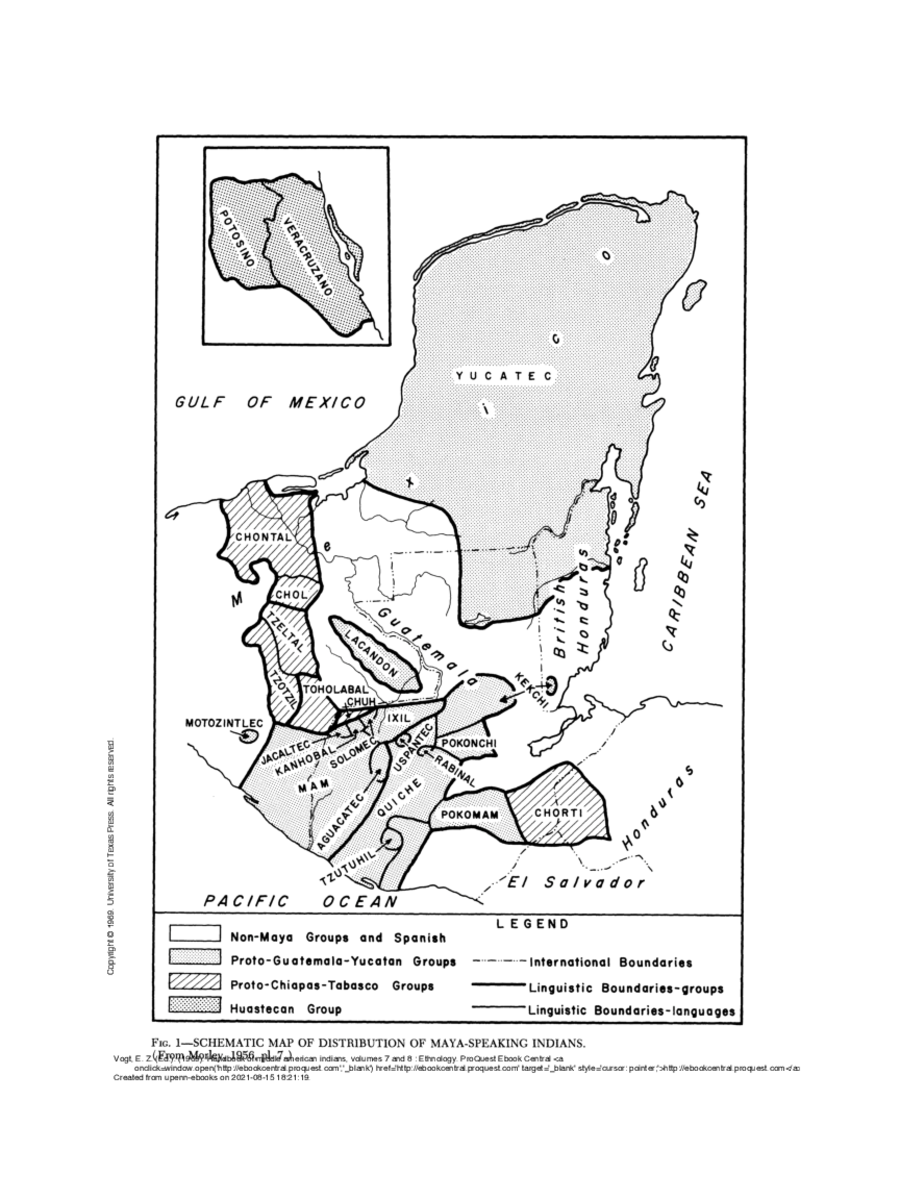
Dispossesions in the Americas

Dispossesions in the Americas

  • Lar
  • Explorar
  • Autores
  • Sobre
  • Arte
  • Corpos
  • Currículos
  • Patrimônio Cultural
  • Mapas
  • Territórios
Voltar à seção Explorar

Lendo em Inglês

Mapa

SCHEMATIC MAP OF DISTRIBUTION OF MAYA-SPEAKING INDIANS (From Morley, 1956, pl.7)

  • MORLEY, SYLVANUS

Publicado: 1956

  • Baixar Imagem
  • Baixar Imagem

Lendo em Espanhol

Mapa

SCHEMATIC MAP OF DISTRIBUTION OF MAYA-SPEAKING INDIANS (From Morley, 1956, pl.7)

  • MORLEY, SYLVANUS

Publicado: 1956

  • Baixar Imagem
  • Baixar Imagem
Mapa

SCHEMATIC MAP OF DISTRIBUTION OF MAYA-SPEAKING INDIANS (From Morley, 1956, pl.7)

  • MORLEY, SYLVANUS

Publicado: 1956

  • Baixar Imagem

Povos

  • CHORTI
  • POKOMAM
  • TZUTUHIL
  • QUICHE
  • AGUACATEC
  • USPANTEC
  • POKONCHI
  • MAM
  • IXIL
  • SOLOMEC
  • KANHOBAL
  • JACALTEC
  • CHUH
  • KEKCHI
  • TOHOLABAL
  • MOTOZINTLEC
  • TZOTZIL
  • TZELTAL
  • LANCANDON
  • CHOL
  • CHONTAL

Citação

Vogt, Evon Z. "The Maya: Introduction." In Ethnology, edited by Robert Wauchope and Evon Z. Vogt, 21. Vols. 7-8 of Handbook of Middle American Indians. Austin: University of Texas Press, 1969. https://ebookcentral-proquest-com.proxy.library.upenn.edu/lib/upenn-ebooks/reader.action?docID=4826335&ppg=32.

  • Baixar Imagem

Itens Relacionados

Côtes du Brésil de Bahia de todos los Sancts à Spirito Santo

Côtes du Brésil de Bahia de todos los Sancts à Spirito Santo

Mapa 1779
Detail from the 1770 copy of Francisco Álvarez Barreiro’s 1728 map of northern New Spain illustrating Spanish mapping of Indian domains in southern Texas and along the Gulf Coast, especially through the repetition of labels: “tierra de los Pampopas,” “tierra de los Carrizos,” “tierra de los Cujanes,” etc.

Detail from the 1770 copy of Francisco Álvarez Barreiro’s 1728 map of northern New Spain illustrating Spanish mapping of Indian domains in southern Texas and along the Gulf Coast, especially through the repetition of labels: “tierra de los Pampopas,” “tierra de los Carrizos,” “tierra de los Cujanes,” etc.

Mapa 1728
Indigenous provinces in El Salvador around 1500. (Adapted from Fowler 1989140-141, figure 5, with additional information from Lehman 1920:719, with modifications by the author.)

Indigenous provinces in El Salvador around 1500. (Adapted from Fowler 1989140-141, figure 5, with additional information from Lehman 1920:719, with modifications by the author.)

Mapa 1500
Amerique Meridionale

Amerique Meridionale

Mapa 1600 - 1699
BRAZIL

BRAZIL

Mapa 1800 - 1850
PUEBLO Q'EQCHI'

PUEBLO Q'EQCHI'

Mapa 2020
Distribution of Indian Languages in Central Mexico

Distribution of Indian Languages in Central Mexico

Mapa 1969
REGIÓN CHINANTECA

REGIÓN CHINANTECA

Mapa 2000

Despossessões nas Américas

Um projeto de

University of Pennsylvania

Copyright 2024

Com o apoio de

Mellon Foundation

Projeto e desenvolvimento do site

Element 84

Créditos da arte

Vogt, Evon Z. “The Maya: Introduction.” In Ethnology, edited by Robert Wauchope and Evon Z. Vogt, 21. Vols. 7-8 of Handbook of Middle American Indians. Austin: University of Texas Press, 1969. https://ebookcentral-proquest-com.proxy.library.upenn.edu/lib/upenn-ebooks/reader.action?docID=4826335&ppg=32.

Páginas do site

  • Lar
  • Explorar
  • Autores
  • Sobre
  • Arte
  • Corpos
  • Currículos
  • Patrimônio Cultural
  • Mapas
  • Territórios