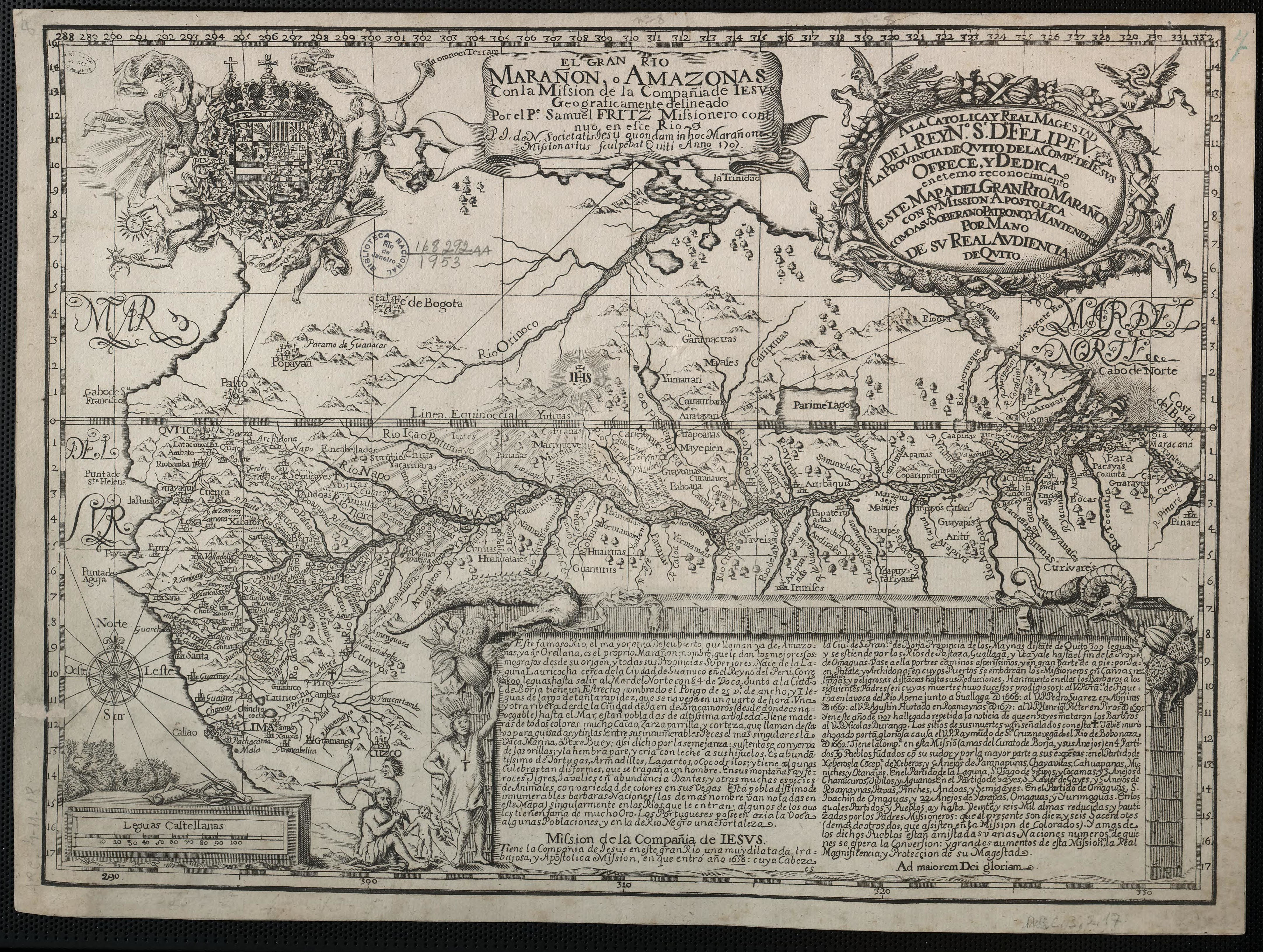
Dispossesions in the Americas

Dispossesions in the Americas

  • Lar
  • Explorar
  • Autores
  • Sobre
  • Arte
  • Corpos
  • Currículos
  • Patrimônio Cultural
  • Mapas
  • Territórios
Voltar à seção Explorar

Lendo em Inglês

Mapa 1817

CARTA COROGRAFICA DE LA REPÚBLICA DEL ECUADOR / MANUEL VILLAVICENCIO ;LIT. E IMP. DE F. MAYER Y CA.

  • MANUEL VILLAVICENCIO

Publicado: 1822-1871

  • Baixar Imagem
  • Baixar Imagem

Lendo em Espanhol

Mapa 1817

CARTA COROGRAFICA DE LA REPÚBLICA DEL ECUADOR / MANUEL VILLAVICENCIO ;LIT. E IMP. DE F. MAYER Y CA.

  • MANUEL VILLAVICENCIO

Publicado: 1822-1871

  • Baixar Imagem
  • Baixar Imagem
Mapa 1817

CARTA COROGRAFICA DE LA REPÚBLICA DEL ECUADOR / MANUEL VILLAVICENCIO ;LIT. E IMP. DE F. MAYER Y CA.

  • MANUEL VILLAVICENCIO

Publicado: 1822-1871

  • Baixar Imagem

Povos

  • COFAN
  • CORONADO
  • CAYAPAS
  • CUIYACUS
  • MORONAS
  • ANDOAS
  • COLAMBO
  • WAORANI
  • SECOYA

Citação

Carta corografica de la republica del Ecuador / Manuel Villavicencio ;lit. é imp. de F. Mayer y Ca. Republica del Ecuador. (1817). Yale University Library Digital Collections. Retrieved March 17;2022;from http://digital.library.yale.edu/digital/collection/1026_1/id/2396

  • Baixar Imagem

Itens Relacionados

Misiones de los Indios Andaquiez  : sus navegaciones, y Ríos, naciones, y Caminos desde la Ciudad de Neyva hasta el Pueblo de la Ceja, y de este ála Concepción en el Río Putumayo

Misiones de los Indios Andaquiez : sus navegaciones, y Ríos, naciones, y Caminos desde la Ciudad de Neyva hasta el Pueblo de la Ceja, y de este ála Concepción en el Río Putumayo

Mapa 1792
Izquyluca; Tenayuca. Distrito Federal, 1594

Izquyluca; Tenayuca. Distrito Federal, 1594

Mapa 1594
Mapa histórico-geográfico de Perú, Chile y Buenos Aires

Mapa histórico-geográfico de Perú, Chile y Buenos Aires

Mapa 1830
PUEBLO MASTANAHUA

PUEBLO MASTANAHUA

Mapa 2021
The Marañon or Amazon River with the Mission of the Society of Jesus

The Marañon or Amazon River with the Mission of the Society of Jesus

Mapa 1686 - 1707
Carte du Pérou et Brésil sep.l de Tierra-Firme, de Guyana, et de la Rivière des Amazones: Ce qui fait la partie Boréale de l'Amérique Meridio. le. Par le Sr. D' Anville

Carte du Pérou et Brésil sep.l de Tierra-Firme, de Guyana, et de la Rivière des Amazones: Ce qui fait la partie Boréale de l'Amérique Meridio. le. Par le Sr. D' Anville

Mapa 1700 - 1799
Provincia del Santo Evangelio de Mexico

Provincia del Santo Evangelio de Mexico

Mapa 1500 - 1599
The Course of the River of Amazons.

The Course of the River of Amazons.

Mapa 1600 - 1699

Despossessões nas Américas

Um projeto de

University of Pennsylvania

Copyright 2024

Com o apoio de

Mellon Foundation

Projeto e desenvolvimento do site

Element 84

Créditos da arte

Carta corografica de la republica del Ecuador / Manuel Villavicencio ;lit. é imp. de F. Mayer y Ca. Republica del Ecuador. (1817). Yale University Library Digital Collections. Retrieved March 17;2022;from http://digital.library.yale.edu/digital/collection/1026_1/id/2396

Páginas do site

  • Lar
  • Explorar
  • Autores
  • Sobre
  • Arte
  • Corpos
  • Currículos
  • Patrimônio Cultural
  • Mapas
  • Territórios