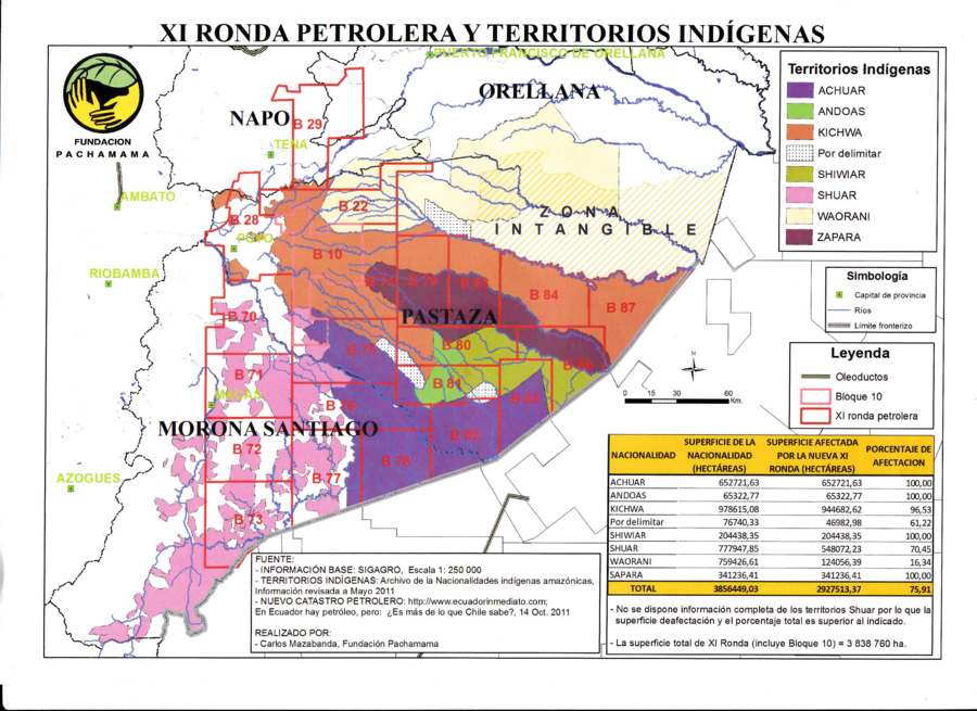
Dispossesions in the Americas

Dispossesions in the Americas

  • Lar
  • Explorar
  • Autores
  • Sobre
  • Arte
  • Corpos
  • Currículos
  • Patrimônio Cultural
  • Mapas
  • Territórios
Voltar à seção Explorar

Lendo em Inglês

Mapa 2011

XI RONDA PETROLERA Y TERRITORIOS INDIGENAS

  • CARLOS MAZABANDA - FUNDACIÓN PACHAMAMA

Publicado: 2011

  • Baixar Imagem
  • Baixar Imagem

Lendo em Espanhol

Mapa 2011

XI RONDA PETROLERA Y TERRITORIOS INDIGENAS

  • CARLOS MAZABANDA - FUNDACIÓN PACHAMAMA

Publicado: 2011

  • Baixar Imagem
  • Baixar Imagem
Mapa 2011

XI RONDA PETROLERA Y TERRITORIOS INDIGENAS

  • CARLOS MAZABANDA - FUNDACIÓN PACHAMAMA

Publicado: 2011

  • Baixar Imagem

Povos

  • ACHUAR
  • ANDOAS
  • KICHWA
  • SHIWIAR
  • SHUAR
  • WAORANI
  • ZAPARA

Citação

Mazabanda;Carlos. "Xi Ronda Petrolera y territorios indígenas." Map. Marcha por la Vida. March 2012. Accessed August 2;2021. https://marchaporlavida.files.wordpress.com/2012/03/mapa-11.jpg.

  • Baixar Imagem

Itens Relacionados

LOCALIZACION GEOGRAFICA DE LAS COMUNIDADES CIMARRONAS EN COLOMBIA DURANTE LOS SIGLOS XVI Y XVII

LOCALIZACION GEOGRAFICA DE LAS COMUNIDADES CIMARRONAS EN COLOMBIA DURANTE LOS SIGLOS XVI Y XVII

Mapa 1500 - 1699
Mosquitia or The Mosquito Shore with The Eastern Part of Yucatán as far as the 20th Degree of North Latitude

Mosquitia or The Mosquito Shore with The Eastern Part of Yucatán as far as the 20th Degree of North Latitude

Mapa 1787
Corredor del conflicto armado en territorios indígenas de la Costa

Corredor del conflicto armado en territorios indígenas de la Costa

Mapa 2020
Carte nouvelle de la France Equinoctiale faite et présentée à sa Majesté par le SieurLe Febure de la Barre son Lieutenant Généralen ces pays au mois de septembre 1665

Carte nouvelle de la France Equinoctiale faite et présentée à sa Majesté par le SieurLe Febure de la Barre son Lieutenant Généralen ces pays au mois de septembre 1665

Mapa 1665
Victoria regia [Vitória-régia]

Victoria regia [Vitória-régia]

Obra de arte
FAMILIAS LINGUISTICAS Y LENGUAS INDIGENAS - SEGUNDA REGION: SUR ANDINO

FAMILIAS LINGUISTICAS Y LENGUAS INDIGENAS - SEGUNDA REGION: SUR ANDINO

Mapa 1989
Linguistic Map of Southern Mexican Highlands and Adjacent Regions at Contact Period

Linguistic Map of Southern Mexican Highlands and Adjacent Regions at Contact Period

Mapa 1969
CARTE DU BRÉSIL

CARTE DU BRÉSIL

Mapa 1851

Despossessões nas Américas

Um projeto de

University of Pennsylvania

Copyright 2024

Com o apoio de

Mellon Foundation

Projeto e desenvolvimento do site

Element 84

Créditos da arte

Mazabanda;Carlos. “Xi Ronda Petrolera y territorios indígenas.” Map. Marcha por la Vida. March 2012. Accessed August 2;2021. https://marchaporlavida.files.wordpress.com/2012/03/mapa-11.jpg.

Páginas do site

  • Lar
  • Explorar
  • Autores
  • Sobre
  • Arte
  • Corpos
  • Currículos
  • Patrimônio Cultural
  • Mapas
  • Territórios