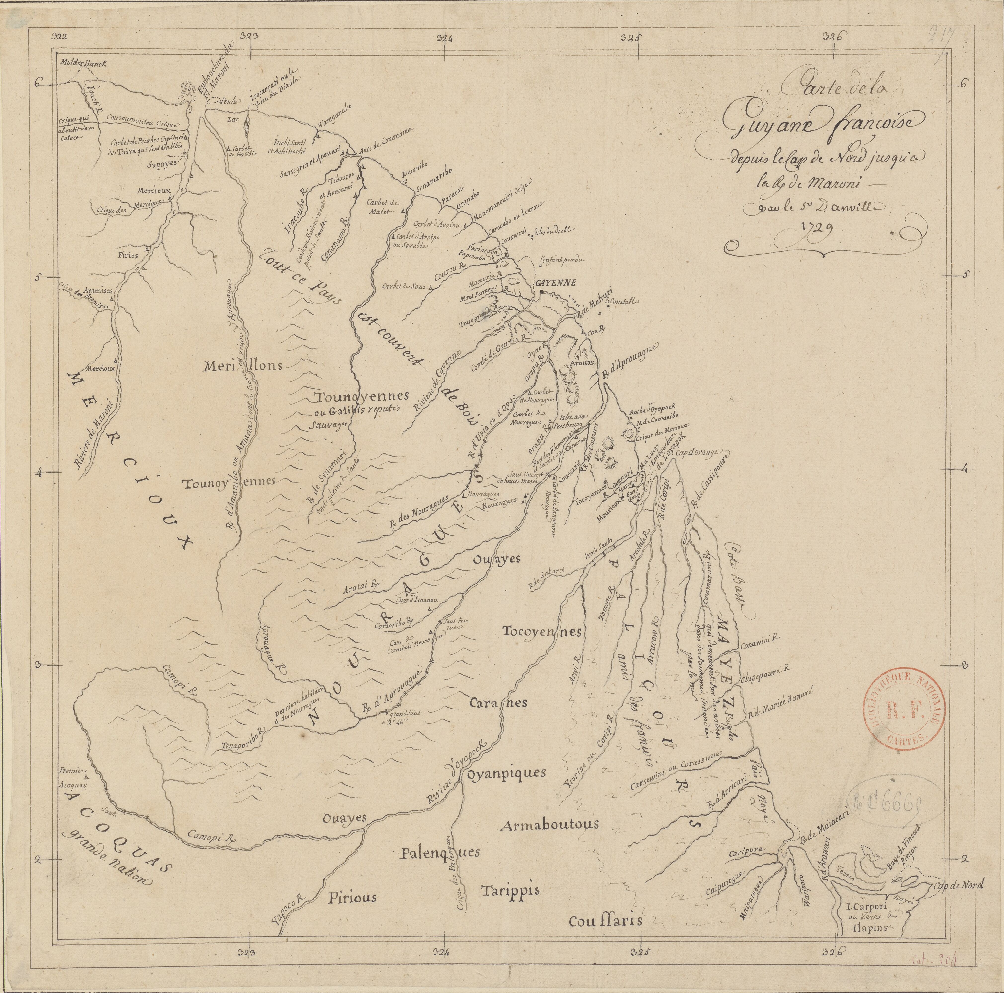
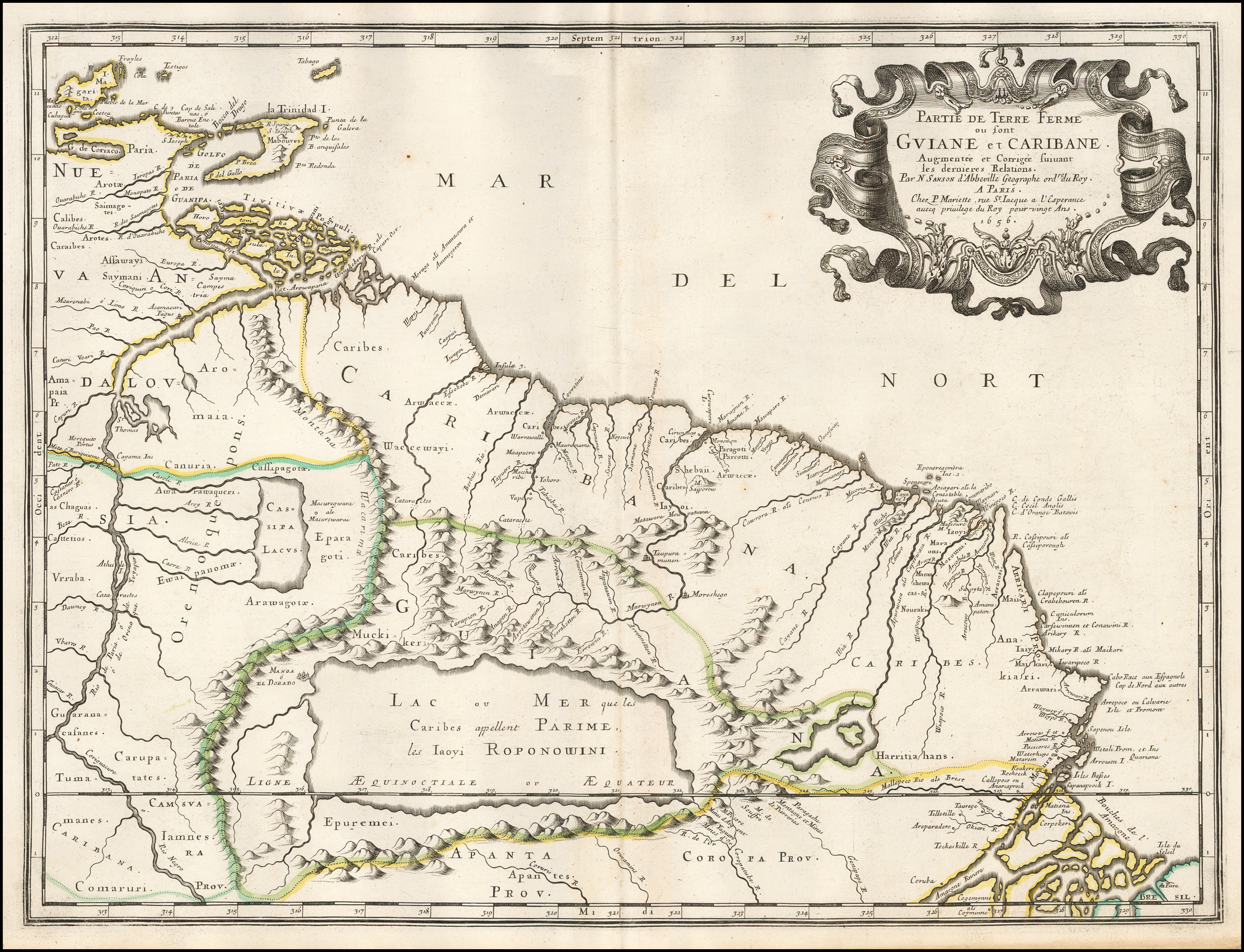
Dispossesions in the Americas

Dispossesions in the Americas

  • Lar
  • Explorar
  • Autores
  • Sobre
  • Arte
  • Corpos
  • Currículos
  • Patrimônio Cultural
  • Mapas
  • Territórios
Voltar à seção Explorar

Lendo em Inglês

Mapa 1594 - 1596

Partie de Terre Ferme ou sont Guiane et Caribane. Augmentée et Corrigée suivant les dernières Relations

  • SANSON;MICOLAS

Publicado: 1656

  • Baixar Imagem
  • Baixar Imagem

Lendo em Espanhol

Mapa 1594 - 1596

Partie de Terre Ferme ou sont Guiane et Caribane. Augmentée et Corrigée suivant les dernières Relations

  • SANSON;MICOLAS

Publicado: 1656

  • Baixar Imagem
  • Baixar Imagem
Mapa 1594 - 1596

Partie de Terre Ferme ou sont Guiane et Caribane. Augmentée et Corrigée suivant les dernières Relations

  • SANSON;MICOLAS

Publicado: 1656

  • Baixar Imagem

Povos

  • CALIBES
  • SAIMAGOTES
  • AROTES
  • KALINAGO
  • SAYMANI
  • CHAGUAS
  • KAKETIO
  • VRRABA
  • GUARANACAFANES
  • TUMAMANES
  • CARAUPATATES
  • CARIBANA
  • COMARURI
  • IAMNES
  • APANTES
  • EPUREMEI
  • CARIBES
  • ARWACCAE
  • WACCEWAYI
  • CANURIA
  • AWARAWAQUERI
  • EWAIPANOMA
  • EPARAGOTOS
  • AROWAGOTOS
  • MUCHIKERI
  • SHEBAII
  • IAYOI
  • HARRITIAHANS
  • ANAKIARI
  • CARUPATES

Citação

Sanson, Nicolas. Partie de Terre Ferme ou sont Guiane et Caribane. Augmentée et Corrigée suivant les dernières Relations. Map. Paris, 1656. Accessed August 26, 2022. https://www.raremaps.com/gallery/detail/50489/partie-de-terre-ferme-ou-sont-guiane-et-caribane-augmentee-sanson.

  • Baixar Imagem

Itens Relacionados

INTENDENCIA DE TABASCO

INTENDENCIA DE TABASCO

Mapa 1800
PLAN DE L'ENTREE DE LA RIVIERE DE CONNANI dans la coste des maÿée province de guiàne

PLAN DE L'ENTREE DE LA RIVIERE DE CONNANI dans la coste des maÿée province de guiàne

Mapa 1755
Sketch map of part of RÍO ORINOCO and RIO CUCHIVERO from a survey by MAJOR STANLEY PATERSON

Sketch map of part of RÍO ORINOCO and RIO CUCHIVERO from a survey by MAJOR STANLEY PATERSON

Mapa 1896
PUEBLO OTOMI

PUEBLO OTOMI

Mapa 2020
Carte de la Guyane françoise depuis le cap de Nord jusqu'à la R. de Maroni, par le S.r D anville

Carte de la Guyane françoise depuis le cap de Nord jusqu'à la R. de Maroni, par le S.r D anville

Mapa 1729
Origin of Mayans according to HLA genes and the uniqueness

Origin of Mayans according to HLA genes and the uniqueness

Mapa
PUEBLO TRIQUI

PUEBLO TRIQUI

Mapa 2020
Geographic Distribution of the Amuzgo

Geographic Distribution of the Amuzgo

Mapa 1969

Despossessões nas Américas

Um projeto de

University of Pennsylvania

Copyright 2024

Com o apoio de

Mellon Foundation

Projeto e desenvolvimento do site

Element 84

Créditos da arte

Sanson, Nicolas. Partie de Terre Ferme ou sont Guiane et Caribane. Augmentée et Corrigée suivant les dernières Relations. Map. Paris, 1656. Accessed August 26, 2022. https://www.raremaps.com/gallery/detail/50489/partie-de-terre-ferme-ou-sont-guiane-et-caribane-augmentee-sanson.

Páginas do site

  • Lar
  • Explorar
  • Autores
  • Sobre
  • Arte
  • Corpos
  • Currículos
  • Patrimônio Cultural
  • Mapas
  • Territórios