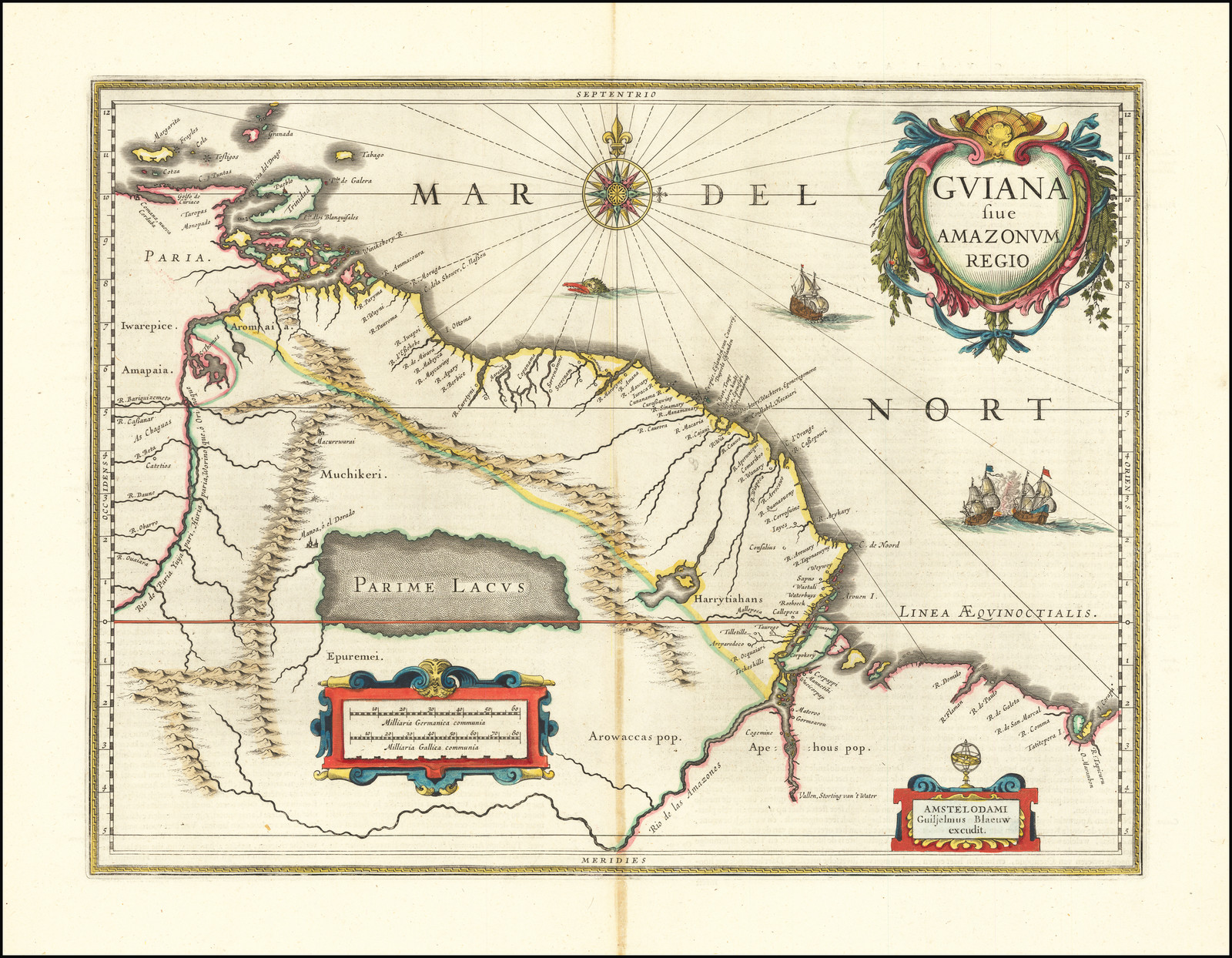
Dispossesions in the Americas

Dispossesions in the Americas

  • Lar
  • Explorar
  • Autores
  • Sobre
  • Arte
  • Corpos
  • Currículos
  • Patrimônio Cultural
  • Mapas
  • Territórios
Voltar à seção Explorar

Lendo em Inglês

Mapa 1600 - 1699

GUIANA sive AMAZONUM REGIO

  • BLAEU;WILLEM JANSZOON

Publicado: CIRCA 1640

  • Baixar Imagem
  • Baixar Imagem

Lendo em Espanhol

Mapa 1600 - 1699

GUIANA sive AMAZONUM REGIO

  • BLAEU;WILLEM JANSZOON

Publicado: CIRCA 1640

  • Baixar Imagem
  • Baixar Imagem
Mapa 1600 - 1699

GUIANA sive AMAZONUM REGIO

  • BLAEU;WILLEM JANSZOON

Publicado: CIRCA 1640

  • Baixar Imagem

Povos

  • APEHOUS
  • ARAWAK
  • EPUREMEI
  • HARRYTIAHANS
  • MUCHIKERI
  • IWAREPICE
  • AROMAIA

Citação

Blaeu, Willem Janszoon. Guiana Sive Amazonum Regio. Map. Amsterdam: Jan Jansson, 1640. Accessed August 23, 2022. https://www.raremaps.com/gallery/detail/66161/lake-parime-and-el-dorado-guiana-sive-amazonum-regio-blaeu.

  • Baixar Imagem

Itens Relacionados

A Map of the United and Independant Provinces of Venezuela and New Grenada.

A Map of the United and Independant Provinces of Venezuela and New Grenada.

Mapa 1800 - 1899
Descripçión de las prouinçias de los yndios cumanagotos y otras naciones de yndios que auitan dichas prouincias desde la ensenada de Santa Fee;corriendo la costa de leste a oeste al cauo de Quadera;término de la gouernación de Caracas;en cuya distançia abrá quarenta leguas de costa;y de la mar a los Llanos quinçe o diez y seis leguas de latitud

Descripçión de las prouinçias de los yndios cumanagotos y otras naciones de yndios que auitan dichas prouincias desde la ensenada de Santa Fee;corriendo la costa de leste a oeste al cauo de Quadera;término de la gouernación de Caracas;en cuya distançia abrá quarenta leguas de costa;y de la mar a los Llanos quinçe o diez y seis leguas de latitud

Mapa 1655
COLOMBIE;GUYANE;VENEZUELA;ÉQUATEUR

COLOMBIE;GUYANE;VENEZUELA;ÉQUATEUR

Mapa 1868
Entree de la Riviere d'Aprouak situee dans la Guyane

Entree de la Riviere d'Aprouak situee dans la Guyane

Mapa 1767
Map of Jamaica showing Maroon areas

Map of Jamaica showing Maroon areas

Mapa 1995
A Sequel of the Seat of War in the West Indies containing… Sub-map title: A large & accurate MAP of part of the Isthmus of Panama, taken from a Spanish drought exhibiting the Country adjacent to that City and Puerto Bello, with the Roads and Course of the River CHAGRE, by which the Treasure of the South Sea is conveyed a cross the Isthmus

A Sequel of the Seat of War in the West Indies containing… Sub-map title: A large & accurate MAP of part of the Isthmus of Panama, taken from a Spanish drought exhibiting the Country adjacent to that City and Puerto Bello, with the Roads and Course of the River CHAGRE, by which the Treasure of the South Sea is conveyed a cross the Isthmus

Mapa 1740
Bogando [Vogando]

Bogando [Vogando]

Obra de arte
TERRITORIO DEL PUEBLO SHUAR ATRUAM

TERRITORIO DEL PUEBLO SHUAR ATRUAM

Mapa 2017

Despossessões nas Américas

Um projeto de

University of Pennsylvania

Copyright 2024

Com o apoio de

Mellon Foundation

Projeto e desenvolvimento do site

Element 84

Créditos da arte

Blaeu, Willem Janszoon. Guiana Sive Amazonum Regio. Map. Amsterdam: Jan Jansson, 1640. Accessed August 23, 2022. https://www.raremaps.com/gallery/detail/66161/lake-parime-and-el-dorado-guiana-sive-amazonum-regio-blaeu.

Páginas do site

  • Lar
  • Explorar
  • Autores
  • Sobre
  • Arte
  • Corpos
  • Currículos
  • Patrimônio Cultural
  • Mapas
  • Territórios