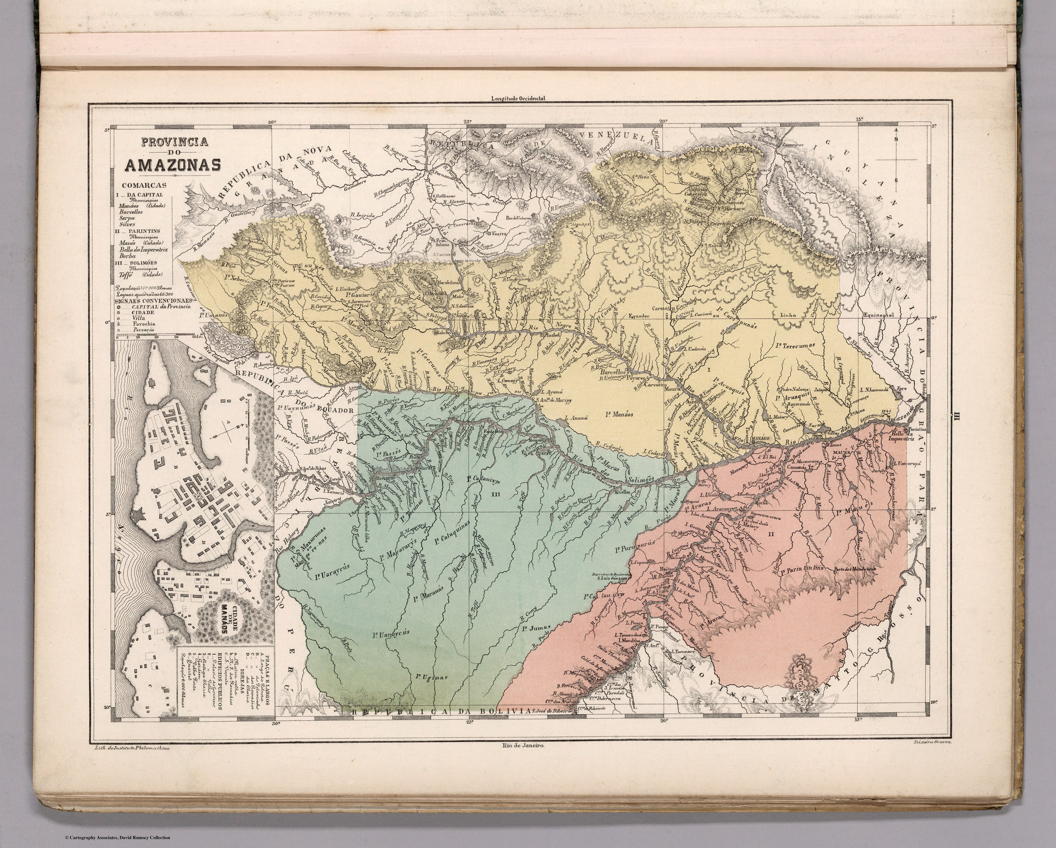
Dispossesions in the Americas

Dispossesions in the Americas

  • Lar
  • Explorar
  • Autores
  • Sobre
  • Arte
  • Corpos
  • Currículos
  • Patrimônio Cultural
  • Mapas
  • Territórios
Voltar à seção Explorar

Lendo em Inglês

Mapa 1800 - 1850

Provincia do AMAZONAS

  • MENDES, CANDIDO

Publicado: 1868

  • Baixar Imagem
  • Baixar Imagem

Lendo em Espanhol

Mapa 1800 - 1850

Provincia do AMAZONAS

  • MENDES, CANDIDO

Publicado: 1868

  • Baixar Imagem
  • Baixar Imagem
Mapa 1800 - 1850

Provincia do AMAZONAS

  • MENDES, CANDIDO

Publicado: 1868

  • Baixar Imagem

Povos

  • CARIPUNAS
  • CARAHYAHY
  • HIABAANAS
  • GAUIARIS
  • MACUS
  • UAUPEZ
  • SIROAS
  • YUCUNAS
  • XEBEROS
  • UMAUAS
  • JURY-TABOCAS
  • JURIS
  • COERUNAS
  • UAYNUMAS
  • PASSES
  • XUMANAS
  • TECUNAS
  • MANAOS
  • MURAS
  • CATAUIXYS
  • TERECUMAS
  • ARUAQUIS
  • ARARAS
  • MAUES
  • PARINTINTINS
  • ARRAIAS
  • PURUPURUS
  • JUMAS
  • CATUQUINAS
  • MACARARYS
  • UARAYCUS
  • MAXURUNAS
  • MARAUAS
  • UGINAS

Citação

Mendes, Candido. Provincia do Amazonas. Map. Rio de Janeiro: Lithographia do Instituto Philomathico, 1868. Accessed August 14, 2023. https://www.davidrumsey.com/ luna/servlet/detail/RUMSEY~8~1~305748~90076439.

  • Baixar Imagem

Itens Relacionados

Terra Indígena Guarani do Aguapeú

Terra Indígena Guarani do Aguapeú

Mapa 2012
Terra Indígena Vale do Javarí

Terra Indígena Vale do Javarí

Mapa 2000 - 2099
REPRESENTACIÓN EN FORMA DE TRÍPTICO DE LAS TIERRAS DE TEPAL;CUENCA;CORRESPONDE AL EXPEDIENTE PROMOVIDO POR POSESIÓN DE TIERRAS ENTRE LOS INDÍGENAS DE SANTA ANA DE PICHACAY CONTRA MARÍA Y FRANCISCA CAZAR

REPRESENTACIÓN EN FORMA DE TRÍPTICO DE LAS TIERRAS DE TEPAL;CUENCA;CORRESPONDE AL EXPEDIENTE PROMOVIDO POR POSESIÓN DE TIERRAS ENTRE LOS INDÍGENAS DE SANTA ANA DE PICHACAY CONTRA MARÍA Y FRANCISCA CAZAR

Mapa 1828
Partie de la Colombie et du Bresil. Amer. Merid. no. 9. (Dresse par Ph. Vandermaelen;lithographie par H. Ode. Cinquieme partie - Amer. merid. Bruxelles. 1827)

Partie de la Colombie et du Bresil. Amer. Merid. no. 9. (Dresse par Ph. Vandermaelen;lithographie par H. Ode. Cinquieme partie - Amer. merid. Bruxelles. 1827)

Mapa 1827
Map of the RIVER JURUÁ

Map of the RIVER JURUÁ

Mapa 1869
Ethnolinguistic territories of the Californias

Ethnolinguistic territories of the Californias

Mapa 2007
PUEBLO KAKATAIBO

PUEBLO KAKATAIBO

Mapa 2021
Plano de la nueba redución de Yndios Tobas
     nombrada San Bernardo de Vertiz

Plano de la nueba redución de Yndios Tobas nombrada San Bernardo de Vertiz

Mapa 1781

Despossessões nas Américas

Um projeto de

University of Pennsylvania

Copyright 2024

Com o apoio de

Mellon Foundation

Projeto e desenvolvimento do site

Element 84

Créditos da arte

Mendes, Candido. Provincia do Amazonas. Map. Rio de Janeiro: Lithographia do Instituto Philomathico, 1868. Accessed August 14, 2023. https://www.davidrumsey.com/ luna/servlet/detail/RUMSEY8130574890076439.

Páginas do site

  • Lar
  • Explorar
  • Autores
  • Sobre
  • Arte
  • Corpos
  • Currículos
  • Patrimônio Cultural
  • Mapas
  • Territórios