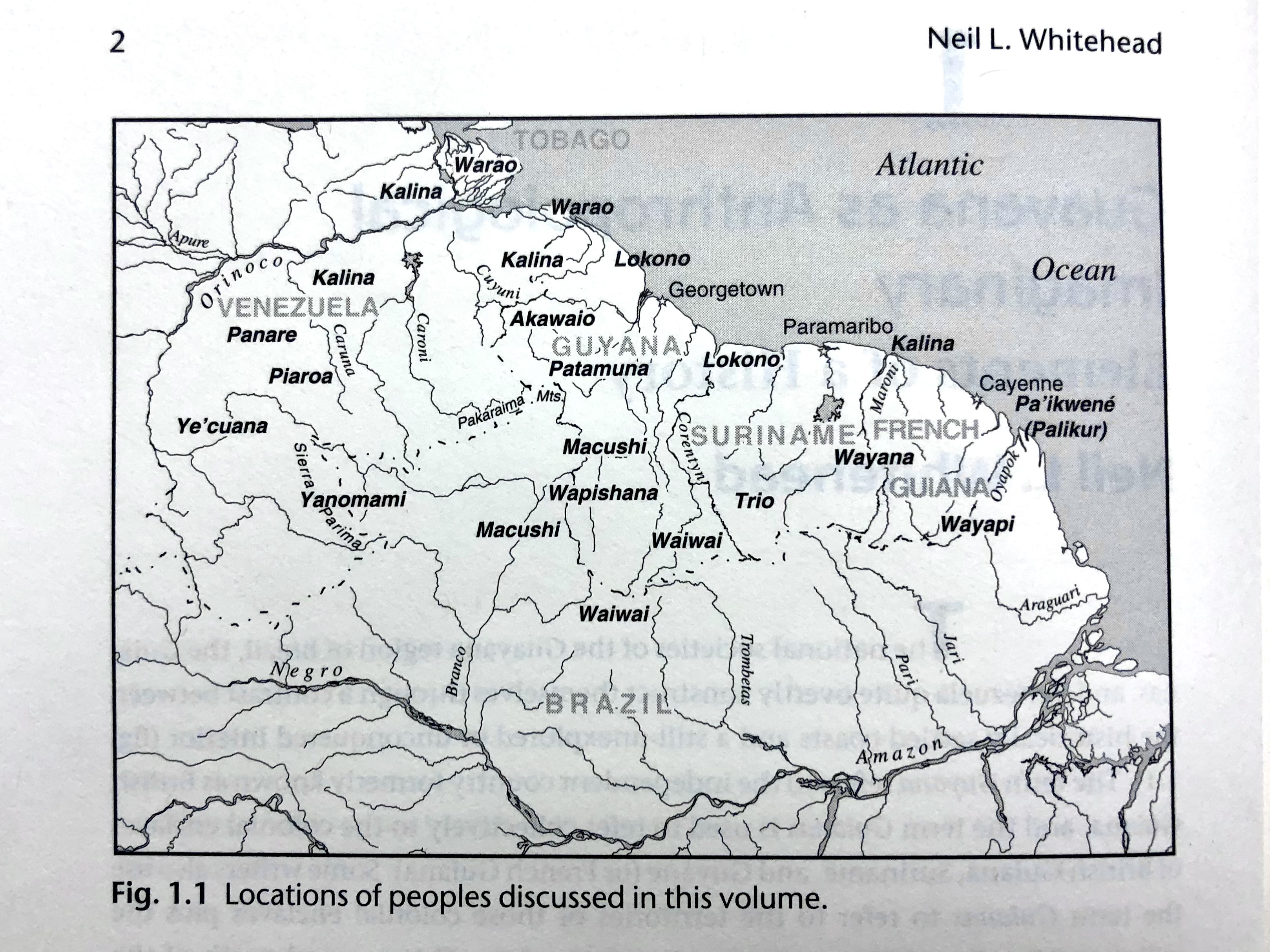
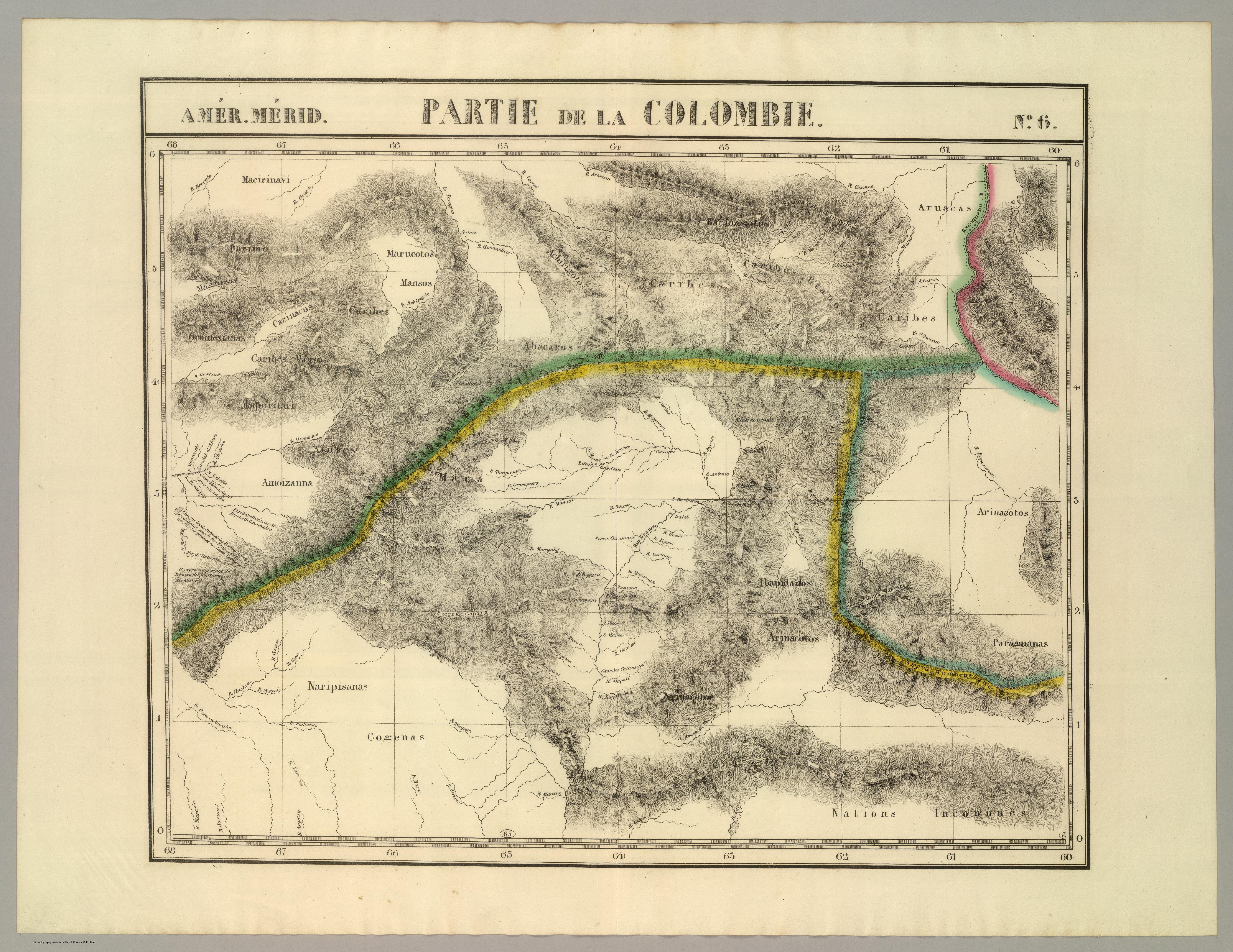
Dispossesions in the Americas

Dispossesions in the Americas

  • Inicio
  • Explorar
  • Autores
  • Sobre
  • Arte
  • Cuerpos
  • Planes de Estudio
  • Herencia Cultural
  • Mapas
  • Territorios
Volver a Explorar

Leyendo en Inglés

Mapa 1827

PARTIE DE LA COLOMBIE

  • VANDERMAELEN;PHILIPPE

Publicado: 1827

  • Descargar Imágen
  • Descargar Imágen
Mapa 1827

PARTIE DE LA COLOMBIE

  • VANDERMAELEN;PHILIPPE

Publicado: 1827

  • Descargar Imágen

Pueblos

  • PARIME
  • YEKUANA
  • MARUCOTOS
  • ACHIRIGOTO
  • PEMON
  • CARIBE
  • ARUACA
  • ABACARA
  • CARINACO
  • OCOMESIANA
  • MAGNISAS
  • ATURES
  • AMOIZANA
  • MACOS
  • ARNACOTO
  • IBAPIDANOS
  • MARIPISANAS
  • KAKETIO
  • COGENAS
  • INCONNUES

Citas

Vandermaelen;Philippe. Partie de la Colombie. Amer. Merid. no. 6. Map. Brussels: Ph. Vandermaelen;1827. Accessed December 28;2022. https://www.davidrumsey.com/luna/servlet/detail/RUMSEY~8~1~25245~5500105:Partie%2C-Colombie--Amer--Merid--6-?sort=pub_list_no_initialsort%2Cpub_date%2Cpub_list_no%2Cseries_no&qvq=w4s:/where%2FVenezuela;q:venezuela;sort:pub_list_no_initialsort%2Cpub_date%2Cpub_list_no%2Cseries_no;lc:RUMSEY~8~1&mi=170&trs=267#.

  • Descargar Imágen

Artículos Relacionados

Côte du Perou

Côte du Perou

Mapa 1707
Fig. 1.1 Locations of peoples discussed in this volume

Fig. 1.1 Locations of peoples discussed in this volume

Mapa 1900 - 1999
ARCHEOLOGICAL MAP OF MIDDLE AMERICA

ARCHEOLOGICAL MAP OF MIDDLE AMERICA

Mapa 1968
A Sequel of the Seat of War in the West Indies containing… Sub-map title: A large & accurate MAP of part of the Isthmus of Panama, taken from a Spanish drought exhibiting the Country adjacent to that City and Puerto Bello, with the Roads and Course of the River CHAGRE, by which the Treasure of the South Sea is conveyed a cross the Isthmus

A Sequel of the Seat of War in the West Indies containing… Sub-map title: A large & accurate MAP of part of the Isthmus of Panama, taken from a Spanish drought exhibiting the Country adjacent to that City and Puerto Bello, with the Roads and Course of the River CHAGRE, by which the Treasure of the South Sea is conveyed a cross the Isthmus

Mapa 1740
ANGAITÉ

ANGAITÉ

Mapa 2015
PROVINCIA DO ESPIRITO SANTO

PROVINCIA DO ESPIRITO SANTO

Mapa 1800 - 1850
MICHOACÁN

MICHOACÁN

Mapa 2015
Pueblos de Indios Diaguita Durante la Colonia.

Pueblos de Indios Diaguita Durante la Colonia.

Mapa 1500 - 1800

Despojos en las Américas

Un Proyecto de

University of Pennsylvania

Copyright 2024

Con el apoyo de

Mellon Foundation

Diseño y Desarrollo del Sitio

Element 84

Créditos Artísticos

Vandermaelen;Philippe. Partie de la Colombie. Amer. Merid. no. 6. Map. Brussels: Ph. Vandermaelen;1827. Accessed December 28;2022. https://www.davidrumsey.com/luna/servlet/detail/RUMSEY~8~1~25245~5500105:Partie%2C-Colombie--Amer--Merid--6-?sort=pub_list_no_initialsort%2Cpub_date%2Cpub_list_no%2Cseries_no&qvq=w4s:/where%2FVenezuela;q:venezuela;sort:pub_list_no_initialsort%2Cpub_date%2Cpub_list_no%2Cseries_no;lc:RUMSEY~8~1&mi=170&trs=267#.

Páginas del Sitio

  • Inicio
  • Explorar
  • Autores
  • Sobre
  • Arte
  • Cuerpos
  • Planes de Estudio
  • Herencia Cultural
  • Mapas
  • Territorios