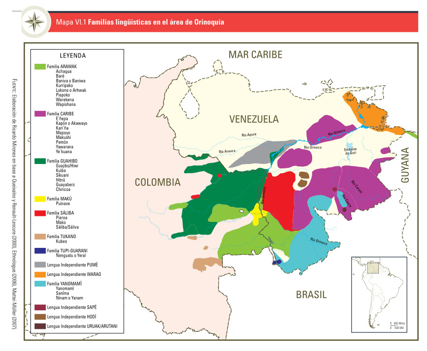
Dispossesions in the Americas

Dispossesions in the Americas

  • Inicio
  • Explorar
  • Autores
  • Sobre
  • Arte
  • Cuerpos
  • Planes de Estudio
  • Herencia Cultural
  • Mapas
  • Territorios
Volver a Explorar

Leyendo en Inglés

Mapa 2009

Mapa VI.1 Familias lingüísticas en el área de Orinoquía

  • UNICEF;FUNPROEIB ANDES

Publicado: 2009

  • Descargar Imágen
  • Descargar Imágen
Mapa 2009

Mapa VI.1 Familias lingüísticas en el área de Orinoquía

  • UNICEF;FUNPROEIB ANDES

Publicado: 2009

  • Descargar Imágen

Pueblos

  • ACHAGUA
  • BANIVA
  • BARE
  • CHIRICOA
  • ENEPA
  • GUAJIBO
  • GUAYABERO
  • HITNU
  • KAPON
  • KARINA
  • KUBEO
  • KUIBA
  • KURRIPAKO
  • LOKONO
  • MAKO
  • MAKUSHI
  • MAPOYO
  • PEMON
  • PIAPOKO
  • PIAROA
  • PUINAVE
  • PUME SALIBA
  • SIKUANI
  • WAPISHANA
  • WAREKENA
  • YAWARANA
  • YEKUANA
  • YERAL

Citas

Gobierno de España Ministerio de Asuntos Exteriores y de Cooperación. Atlas Sociolingü̈ístico de Pueblos Indígenas en América Latina. By UNICEF and FUNPROEIB Andes. Report no. 1. 2009. Accessed November 7;2021. https://www.unicef.org/lac/media/9796/file/Atlas%20sociolinguistico%20de%20pueblos%20ind%C3%ADgenas%20en%20ALC-Tomo%202.pdf.

  • Descargar Imágen

Artículos Relacionados

Costa Rica;Nicaragua;Guatemala y Honduras

Costa Rica;Nicaragua;Guatemala y Honduras

Mapa 1800 - 1801
Reproduction of a 4th century mural painted on the wall of a royal residence at La Sufricaya in the Peten region of Guatemala. Mural 6 North.

Reproduction of a 4th century mural painted on the wall of a royal residence at La Sufricaya in the Peten region of Guatemala. Mural 6 North.

Mapa 300 - 400
Mapa Grupos Indígenas

Mapa Grupos Indígenas

Mapa 2011
Distribución geográfica de las ramas mayores de los idiomas mayas en su origen histórico.

Distribución geográfica de las ramas mayores de los idiomas mayas en su origen histórico.

Mapa
INTENDENCIA DE DURANGO

INTENDENCIA DE DURANGO

Mapa 1800
The Marañon or Amazon River with the Mission of the Society of Jesus

The Marañon or Amazon River with the Mission of the Society of Jesus

Mapa 1686 - 1707
INTENDENCIA DE SAN LUIS POTOSÍ

INTENDENCIA DE SAN LUIS POTOSÍ

Mapa 1800
PUEBLO TEPEHUANO DEL NORTE

PUEBLO TEPEHUANO DEL NORTE

Mapa 2020

Despojos en las Américas

Un Proyecto de

University of Pennsylvania

Copyright 2024

Con el apoyo de

Mellon Foundation

Diseño y Desarrollo del Sitio

Element 84

Créditos Artísticos

Gobierno de España Ministerio de Asuntos Exteriores y de Cooperación. Atlas Sociolingü̈ístico de Pueblos Indígenas en América Latina. By UNICEF and FUNPROEIB Andes. Report no. 1. 2009. Accessed November 7;2021. https://www.unicef.org/lac/media/9796/file/Atlas%20sociolinguistico%20de%20pueblos%20ind%C3%ADgenas%20en%20ALC-Tomo%202.pdf.

Páginas del Sitio

  • Inicio
  • Explorar
  • Autores
  • Sobre
  • Arte
  • Cuerpos
  • Planes de Estudio
  • Herencia Cultural
  • Mapas
  • Territorios