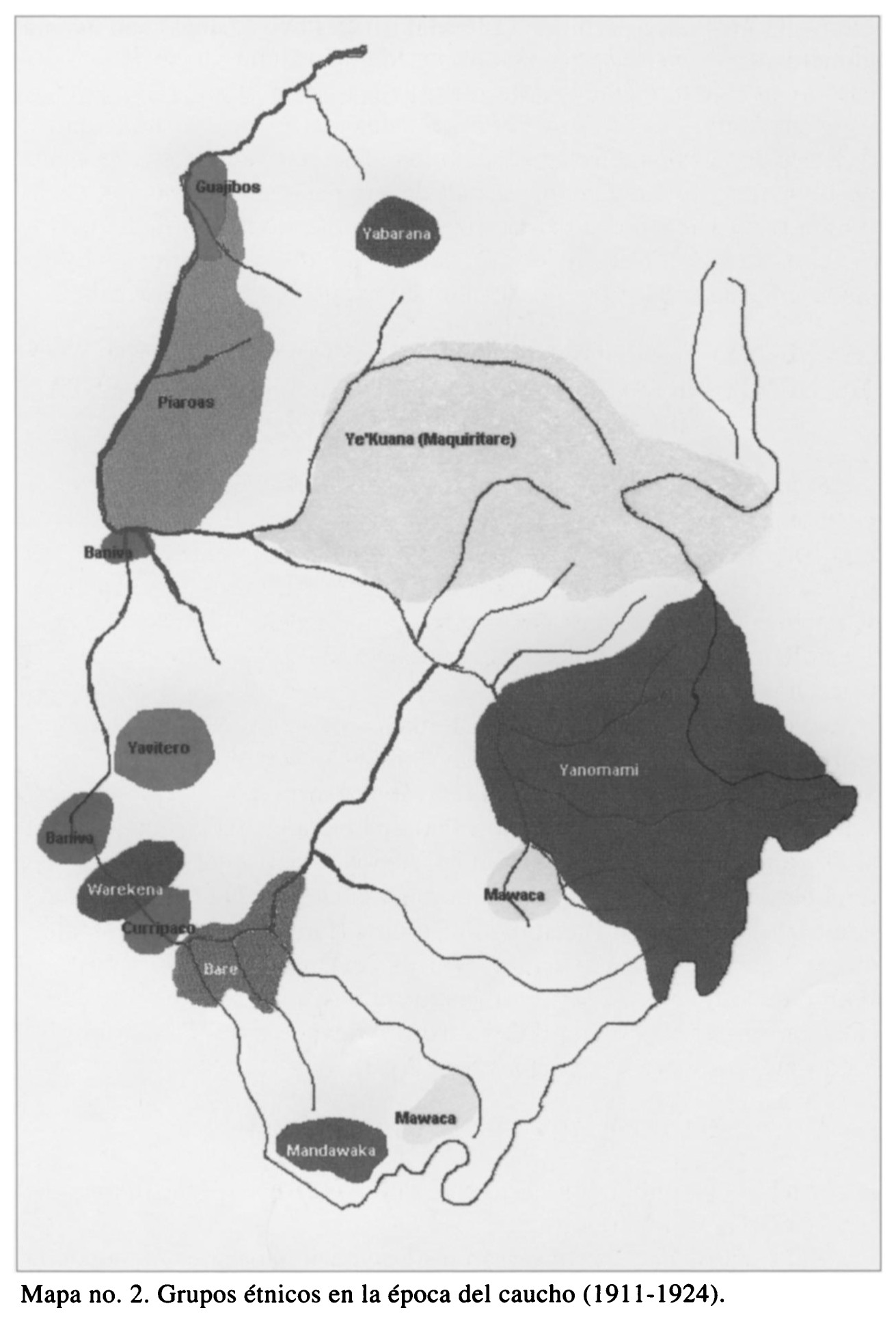
Dispossesions in the Americas

Dispossesions in the Americas

  • Inicio
  • Explorar
  • Autores
  • Sobre
  • Arte
  • Cuerpos
  • Planes de Estudio
  • Herencia Cultural
  • Mapas
  • Territorios
Volver a Explorar

Leyendo en Inglés

Mapa 1911 - 1924

Grupos étnicos en la época del caucho (1911-1924)

  • DEOGENES EDGILDO PALAU;GEOG.

Publicado: 1999

  • Descargar Imágen
  • Descargar Imágen
Mapa 1911 - 1924

Grupos étnicos en la época del caucho (1911-1924)

  • DEOGENES EDGILDO PALAU;GEOG.

Publicado: 1999

  • Descargar Imágen

Pueblos

  • GUAJIBOS
  • YABARANA
  • PIAROAS
  • BANIVA
  • YAVITERO
  • WAREKENA
  • CURRIPACO
  • BARE
  • MANDAWAKA
  • MAWACA
  • YANOMAMI
  • YEKUANA

Cita

Diógenes Edgilgo Palau;Geóg. "Los Pueblos Indigenas del Amazonas Venezolano desde Humboldt a Nuestros Dias: Preservacion del Ambiente Y Manejo Sostenible." Northeastern Naturalist 8;no. 1 (2001): 135-56. https://www-jstor-org.proxy.library.upenn.edu/stable/4130731?seq=1#metadata_info_tab_contents.

  • Descargar Imágen

Leyendo en Portugués

Mapa 1911 - 1924

Grupos étnicos en la época del caucho (1911-1924)

  • DEOGENES EDGILDO PALAU;GEOG.

Publicado: 1999

  • Descargar Imágen

Pueblos

  • GUAJIBOS
  • YABARANA
  • PIAROAS
  • BANIVA
  • YAVITERO
  • WAREKENA
  • CURRIPACO
  • BARE
  • MANDAWAKA
  • MAWACA
  • YANOMAMI
  • YEKUANA

Cita

Diógenes Edgilgo Palau;Geóg. "Los Pueblos Indigenas del Amazonas Venezolano desde Humboldt a Nuestros Dias: Preservacion del Ambiente Y Manejo Sostenible." Northeastern Naturalist 8;no. 1 (2001): 135-56. https://www-jstor-org.proxy.library.upenn.edu/stable/4130731?seq=1#metadata_info_tab_contents.

  • Descargar Imágen

Artículos Relacionados

AM, Brasil -  Vasija, sin fecha

AM, Brasil - Vasija, sin fecha

Obra de Arte
GUIANA AND VENEZUELA

GUIANA AND VENEZUELA

Mapa 1900 - 1999
TRENTA LEGHE (166 CHILOMETRI) DELL’ ITAMBE’ GUAZÙ

TRENTA LEGHE (166 CHILOMETRI) DELL’ ITAMBE’ GUAZÙ

Mapa 1884
[Mapa de América del Sur desde el Ecuador hasta el Estrecho de Magallanes.]

[Mapa de América del Sur desde el Ecuador hasta el Estrecho de Magallanes.]

Mapa 1600
Partie du Perou. Amer. Merid.

Partie du Perou. Amer. Merid.

Mapa 1827
Carte Croquis DU COURS DE L'ORÉNOQUE de Bolivar àu Rio Meta

Carte Croquis DU COURS DE L'ORÉNOQUE de Bolivar àu Rio Meta

Mapa 1884
Carte de la Guyane française indiquant les établissements pénitentiaires, par V. A. Malte-Brun

Carte de la Guyane française indiquant les établissements pénitentiaires, par V. A. Malte-Brun

Mapa 1874
MAPA DEL ANTIGUO REINO DE GUATEMALA EN LA EPOCA DE SU DESCUBRIMIENTO Y CONQUISTA

MAPA DEL ANTIGUO REINO DE GUATEMALA EN LA EPOCA DE SU DESCUBRIMIENTO Y CONQUISTA

Mapa 1900 - 1999

Despojos en las Américas

Un Proyecto de

University of Pennsylvania

Copyright 2024

Con el apoyo de

Mellon Foundation

Diseño y Desarrollo del Sitio

Element 84

Créditos Artísticos

Diógenes Edgilgo Palau;Geóg. “Los Pueblos Indigenas del Amazonas Venezolano desde Humboldt a Nuestros Dias: Preservacion del Ambiente Y Manejo Sostenible.” Northeastern Naturalist 8;no. 1 (2001): 135-56. https://www-jstor-org.proxy.library.upenn.edu/stable/4130731?seq=1#metadata_info_tab_contents.

Páginas del Sitio

  • Inicio
  • Explorar
  • Autores
  • Sobre
  • Arte
  • Cuerpos
  • Planes de Estudio
  • Herencia Cultural
  • Mapas
  • Territorios