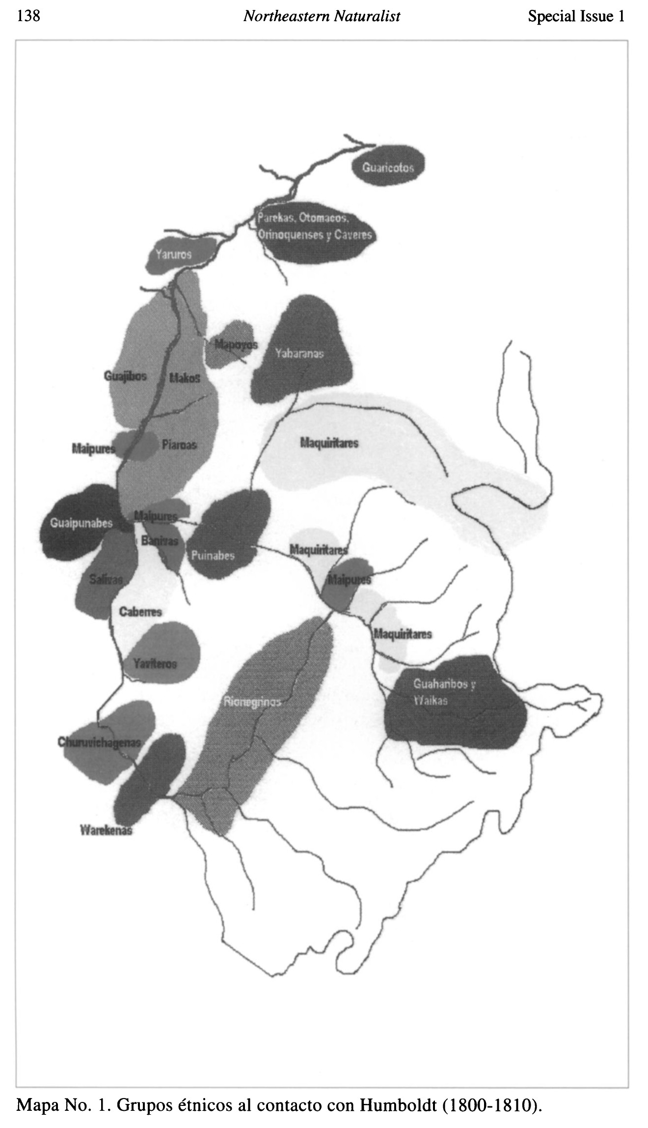
Dispossesions in the Americas

Dispossesions in the Americas

  • Inicio
  • Explorar
  • Autores
  • Sobre
  • Arte
  • Cuerpos
  • Planes de Estudio
  • Herencia Cultural
  • Mapas
  • Territorios
Volver a Explorar

Leyendo en Inglés

Mapa 1800 - 1810

Grupos étnicos al contacto con Humboldt (1800-1810)

  • DEOGENES EDGILDO PALAU;GEOG.

Publicado: 1999

  • Descargar Imágen
  • Descargar Imágen
Mapa 1800 - 1810

Grupos étnicos al contacto con Humboldt (1800-1810)

  • DEOGENES EDGILDO PALAU;GEOG.

Publicado: 1999

  • Descargar Imágen

Pueblos

  • GUARICOTOS
  • PAREKAS
  • OTOMACOS
  • ORINOQUENSES
  • CAVERES
  • YARUROS
  • MAPOYOS
  • YABARANAS
  • GUAJIBOS
  • MAKOS
  • MAIPURES
  • PIAROAS
  • MAQUIRITARES
  • GUAIPUNABES
  • BANIVAS
  • PUNIABES
  • SALIVAS
  • CABERRES YAVITEROS
  • CHURUVICHAGENAS
  • WAREKENAS
  • RIONEGRINAS
  • GUAHARIBOS
  • WAIKAS

Cita

Palau;Geóg. Diógenes Edgilgo. "Los Pueblos Indigenas del Amazonas Venezolano desde Humboldt a Nuestros Dias: Preservacion del Ambiente Y Manejo Sostenible." Northeastern Naturalist 8;no. 1 (2001): 135-56. https://www-jstor-org.proxy.library.upenn.edu/stable/4130731?seq=1#metadata_info_tab_contents.

  • Descargar Imágen

Leyendo en Portugués

Mapa 1800 - 1810

Grupos étnicos al contacto con Humboldt (1800-1810)

  • DEOGENES EDGILDO PALAU;GEOG.

Publicado: 1999

  • Descargar Imágen

Pueblos

  • GUARICOTOS
  • PAREKAS
  • OTOMACOS
  • ORINOQUENSES
  • CAVERES
  • YARUROS
  • MAPOYOS
  • YABARANAS
  • GUAJIBOS
  • MAKOS
  • MAIPURES
  • PIAROAS
  • MAQUIRITARES
  • GUAIPUNABES
  • BANIVAS
  • PUNIABES
  • SALIVAS
  • CABERRES YAVITEROS
  • CHURUVICHAGENAS
  • WAREKENAS
  • RIONEGRINAS
  • GUAHARIBOS
  • WAIKAS

Cita

Palau;Geóg. Diógenes Edgilgo. "Los Pueblos Indigenas del Amazonas Venezolano desde Humboldt a Nuestros Dias: Preservacion del Ambiente Y Manejo Sostenible." Northeastern Naturalist 8;no. 1 (2001): 135-56. https://www-jstor-org.proxy.library.upenn.edu/stable/4130731?seq=1#metadata_info_tab_contents.

  • Descargar Imágen

Artículos Relacionados

Map of the Inca Empire in western South America

Map of the Inca Empire in western South America

Mapa 1310 - 1525
RELACIÓN GEOGRÁFICA DE MEZTITLÁN

RELACIÓN GEOGRÁFICA DE MEZTITLÁN

Mapa 1500 - 1599
ALGUNOS ESTABLECIMIENTOS ESPANOLES Y PUELOS DE INDIOS "REBELDES" A FINALES DEL SIGLO XVII

ALGUNOS ESTABLECIMIENTOS ESPANOLES Y PUELOS DE INDIOS "REBELDES" A FINALES DEL SIGLO XVII

Mapa 1600 - 1699
Map of the Inca Empire

Map of the Inca Empire

Mapa 1490 - 1499
TERRITORIOS ANCESTRALES DE LOS CUATRO PUEBLOS INDIGENAS DE LA SSNM (MAPA APROXIMATIVO DE REFERENCIA)

TERRITORIOS ANCESTRALES DE LOS CUATRO PUEBLOS INDIGENAS DE LA SSNM (MAPA APROXIMATIVO DE REFERENCIA)

Mapa 2009
Blue Creek

Blue Creek

Mapa 1997
Santa Anna

Santa Anna

Mapa 1997
CARTA COROGRAFICA DE LA REPÚBLICA DEL ECUADOR / MANUEL VILLAVICENCIO ;LIT. E IMP. DE F. MAYER Y CA.

CARTA COROGRAFICA DE LA REPÚBLICA DEL ECUADOR / MANUEL VILLAVICENCIO ;LIT. E IMP. DE F. MAYER Y CA.

Mapa 1817

Despojos en las Américas

Un Proyecto de

University of Pennsylvania

Copyright 2024

Con el apoyo de

Mellon Foundation

Diseño y Desarrollo del Sitio

Element 84

Créditos Artísticos

Palau;Geóg. Diógenes Edgilgo. “Los Pueblos Indigenas del Amazonas Venezolano desde Humboldt a Nuestros Dias: Preservacion del Ambiente Y Manejo Sostenible.” Northeastern Naturalist 8;no. 1 (2001): 135-56. https://www-jstor-org.proxy.library.upenn.edu/stable/4130731?seq=1#metadata_info_tab_contents.

Páginas del Sitio

  • Inicio
  • Explorar
  • Autores
  • Sobre
  • Arte
  • Cuerpos
  • Planes de Estudio
  • Herencia Cultural
  • Mapas
  • Territorios