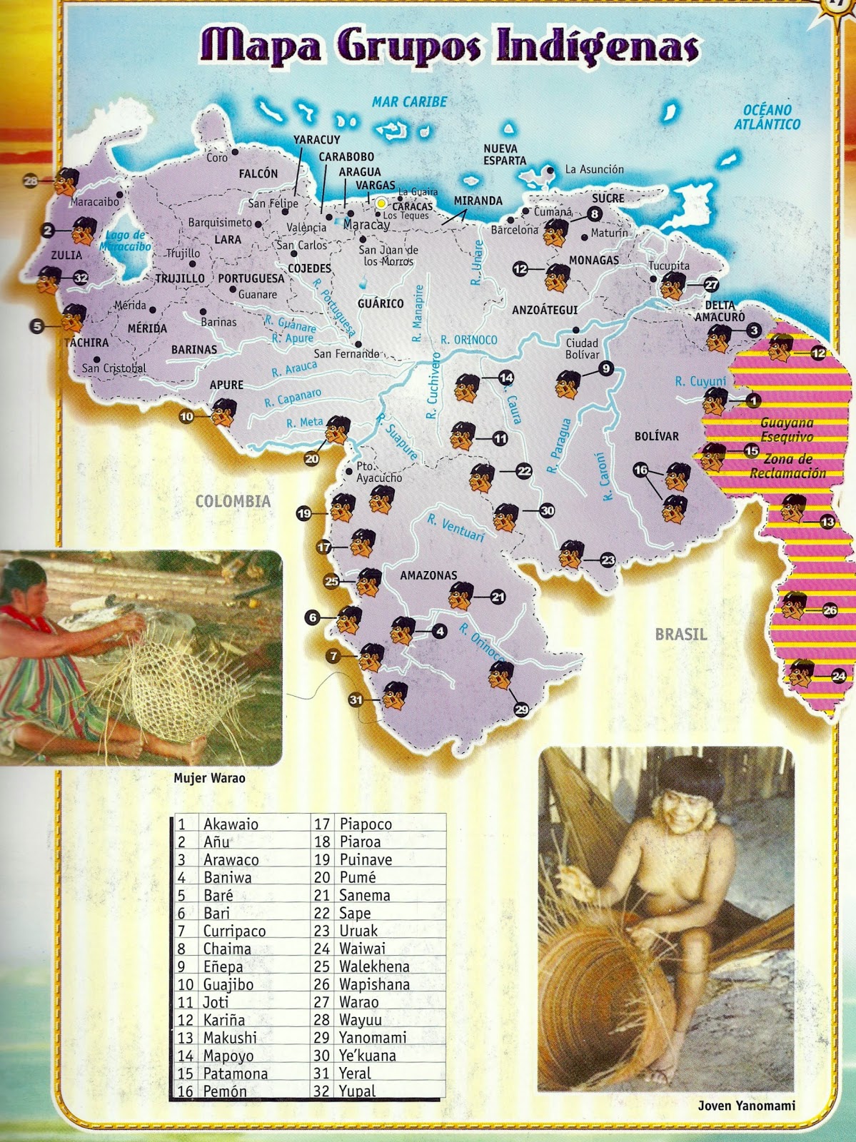
Dispossesions in the Americas

Dispossesions in the Americas

  • Inicio
  • Explorar
  • Autores
  • Sobre
  • Arte
  • Cuerpos
  • Planes de Estudio
  • Herencia Cultural
  • Mapas
  • Territorios
Volver a Explorar

Leyendo en Inglés

Mapa 2011

Mapa Grupos Indígenas

    Publicado: 2011

    • Descargar Imágen
    • Descargar Imágen
    Mapa 2011

    Mapa Grupos Indígenas

      Publicado: 2011

      • Descargar Imágen

      Pueblos

      • AKAWAIO
      • ANUU
      • ARAWAK
      • BARE
      • BARI
      • CHAIMA
      • ENEPA
      • HOTI
      • JIVI
      • KALINA
      • MAKUSHI
      • MAPOYO
      • PEMON
      • PIAROA
      • PUINAVE
      • SANEMA
      • SAPE
      • SOTO
      • TSASE
      • URUAK
      • WAKUENAI
      • WALIMANAI
      • WAPISHANA
      • WARAO
      • WAYUU
      • YANOMAMI
      • YARURO
      • YERAL
      • PATAMONA
      • WAIWAI
      • WALEKHENA
      • YUPAL

      Citas

      "Venezuela: los pueblos indígenas denuncian aún más obstáculos para el reconocimiento de sus derechos sobre la tierra." La Guayana Esequiba. Last modified April 21;2011. Accessed March 13;2022. http://laguayanaesequiba.blogspot.com/2011/04/venezuela-los-pueblos-indigenas.html.

      • Descargar Imágen

      Artículos Relacionados

      VENEZUELA

      VENEZUELA

      Mapa 1885
      El cuitlateco y las lenguas vecinas

      El cuitlateco y las lenguas vecinas

      Mapa 2019
      Grupos étnicos en la actualidad (1999)

      Grupos étnicos en la actualidad (1999)

      Mapa 1999
      Coste de Guayane autrement France equinoctiale en la Terre Ferme d'Amérique.

      Coste de Guayane autrement France equinoctiale en la Terre Ferme d'Amérique.

      Mapa 1677
      Mapa de la Republica de Guatemala

      Mapa de la Republica de Guatemala

      Mapa 1800
      Expedition Koch-Grunberg in Nordbrasilien und Venezuela in den Jahren 1911-1913

      Expedition Koch-Grunberg in Nordbrasilien und Venezuela in den Jahren 1911-1913

      Mapa 1911 - 1913
      PARAGUAY UND DER NÖRDLICHE THEIL DER ARGENTINISCHEN REPUBLIK

      PARAGUAY UND DER NÖRDLICHE THEIL DER ARGENTINISCHEN REPUBLIK

      Mapa 1853 - 56
      A Sequel of the Seat of War in the West Indies containing… Sub-map title: A large & accurate MAP of part of the Isthmus of Panama, taken from a Spanish drought exhibiting the Country adjacent to that City and Puerto Bello, with the Roads and Course of the River CHAGRE, by which the Treasure of the South Sea is conveyed a cross the Isthmus

      A Sequel of the Seat of War in the West Indies containing… Sub-map title: A large & accurate MAP of part of the Isthmus of Panama, taken from a Spanish drought exhibiting the Country adjacent to that City and Puerto Bello, with the Roads and Course of the River CHAGRE, by which the Treasure of the South Sea is conveyed a cross the Isthmus

      Mapa 1740

      Despojos en las Américas

      Un Proyecto de

      University of Pennsylvania

      Copyright 2024

      Con el apoyo de

      Mellon Foundation

      Diseño y Desarrollo del Sitio

      Element 84

      Créditos Artísticos

      “Venezuela: los pueblos indígenas denuncian aún más obstáculos para el reconocimiento de sus derechos sobre la tierra.” La Guayana Esequiba. Last modified April 21;2011. Accessed March 13;2022. http://laguayanaesequiba.blogspot.com/2011/04/venezuela-los-pueblos-indigenas.html.

      Páginas del Sitio

      • Inicio
      • Explorar
      • Autores
      • Sobre
      • Arte
      • Cuerpos
      • Planes de Estudio
      • Herencia Cultural
      • Mapas
      • Territorios