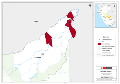
Dispossesions in the Americas

Dispossesions in the Americas

  • Inicio
  • Explorar
  • Autores
  • Sobre
  • Arte
  • Cuerpos
  • Planes de Estudio
  • Herencia Cultural
  • Mapas
  • Territorios
Volver a Explorar

Leyendo en Inglés

Mapa 1740

A Sequel of the Seat of War in the West Indies containing… Sub-map title: A large & accurate MAP of part of the Isthmus of Panama, taken from a Spanish drought exhibiting the Country adjacent to that City and Puerto Bello, with the Roads and Course of the River CHAGRE, by which the Treasure of the South Sea is conveyed a cross the Isthmus

  • BOWEN, EMANUEL

Publicado: 1740

  • Descargar Imágen
  • Descargar Imágen
Mapa 1740

A Sequel of the Seat of War in the West Indies containing… Sub-map title: A large & accurate MAP of part of the Isthmus of Panama, taken from a Spanish drought exhibiting the Country adjacent to that City and Puerto Bello, with the Roads and Course of the River CHAGRE, by which the Treasure of the South Sea is conveyed a cross the Isthmus

  • BOWEN, EMANUEL

Publicado: 1740

  • Descargar Imágen

Pueblos

  • PUEBLA DE INDIOS

Cita

Bowen, E. (1740). A large & accurate MAP of part of the Isthmus of Panama, taken from a Spanish drought exhibiting the Country adjacent to that City and Puerto Bello, with the Roads and Course of the River CHAGRE, by which the Treasure of the South Sea is conveyed a cross the Isthmus [Map]. Gallica. https://gallica.bnf.fr/ark:/12148/btv1b8493166k/f1.item.r=Panama.zoom

  • Descargar Imágen

Leyendo en Portugués

Mapa 1740

A Sequel of the Seat of War in the West Indies containing… Sub-map title: A large & accurate MAP of part of the Isthmus of Panama, taken from a Spanish drought exhibiting the Country adjacent to that City and Puerto Bello, with the Roads and Course of the River CHAGRE, by which the Treasure of the South Sea is conveyed a cross the Isthmus

  • BOWEN, EMANUEL

Publicado: 1740

  • Descargar Imágen

Pueblos

  • PUEBLA DE INDIOS

Cita

Bowen, E. (1740). A large & accurate MAP of part of the Isthmus of Panama, taken from a Spanish drought exhibiting the Country adjacent to that City and Puerto Bello, with the Roads and Course of the River CHAGRE, by which the Treasure of the South Sea is conveyed a cross the Isthmus [Map]. Gallica. https://gallica.bnf.fr/ark:/12148/btv1b8493166k/f1.item.r=Panama.zoom

  • Descargar Imágen

Artículos Relacionados

Area de  las Poblaciones Lipez en Ollague antes de la Reduccion de 1602.

Area de las Poblaciones Lipez en Ollague antes de la Reduccion de 1602.

Mapa 1601
Linguistic Groups in the Cape Region of California

Linguistic Groups in the Cape Region of California

Mapa 1730
Popoloca Towns

Popoloca Towns

Mapa 1950
"Territorio Indígena Matambú (Chorotega)"

"Territorio Indígena Matambú (Chorotega)"

Mapa 2010
TIERRA FIRME E ISLAS ADYACENTES

TIERRA FIRME E ISLAS ADYACENTES

Mapa 1817
CARTE DE LA TERRE FERME de la GUYANE et du Paus des Amazones

CARTE DE LA TERRE FERME de la GUYANE et du Paus des Amazones

Mapa 1785
PUEBLO MADIJA

PUEBLO MADIJA

Mapa 2021
Carta ó Mapa Geográfico de una gran parte del Reino de N. E. [Nueva España], comprendido entre los 19 y 42 grados de latitud Septentrional y entre 249 y 289 grados de longitud del Meridiano de Tenerife, formado de orden del Exc[elentísi]mo S[eño]r B[eilí]o Fr[ey] D[o]n Ant[oni]o Maria Bucarely y Vrsúa p[ar]a indicar la division del Virreinato de México y de las Provincias internas erigidas en Comandancia General en virtud de Reales Órdenes el año 1770

Carta ó Mapa Geográfico de una gran parte del Reino de N. E. [Nueva España], comprendido entre los 19 y 42 grados de latitud Septentrional y entre 249 y 289 grados de longitud del Meridiano de Tenerife, formado de orden del Exc[elentísi]mo S[eño]r B[eilí]o Fr[ey] D[o]n Ant[oni]o Maria Bucarely y Vrsúa p[ar]a indicar la division del Virreinato de México y de las Provincias internas erigidas en Comandancia General en virtud de Reales Órdenes el año 1770

Mapa 1770

Despojos en las Américas

Un Proyecto de

University of Pennsylvania

Copyright 2024

Con el apoyo de

Mellon Foundation

Diseño y Desarrollo del Sitio

Element 84

Créditos Artísticos

Bowen, E. (1740). A large & accurate MAP of part of the Isthmus of Panama, taken from a Spanish drought exhibiting the Country adjacent to that City and Puerto Bello, with the Roads and Course of the River CHAGRE, by which the Treasure of the South Sea is conveyed a cross the Isthmus [Map]. Gallica. https://gallica.bnf.fr/ark:/12148/btv1b8493166k/f1.item.r=Panama.zoom

Páginas del Sitio

  • Inicio
  • Explorar
  • Autores
  • Sobre
  • Arte
  • Cuerpos
  • Planes de Estudio
  • Herencia Cultural
  • Mapas
  • Territorios