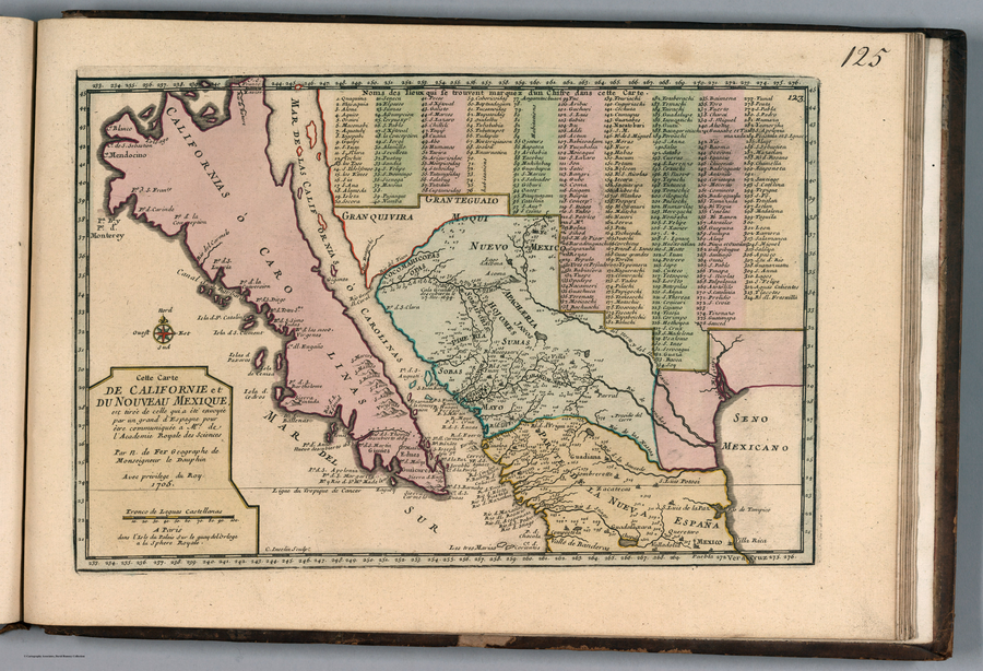
Dispossesions in the Americas

Dispossesions in the Americas

  • Inicio
  • Explorar
  • Autores
  • Sobre
  • Arte
  • Cuerpos
  • Planes de Estudio
  • Herencia Cultural
  • Mapas
  • Territorios
Volver a Explorar

Leyendo en Inglés

Mapa 1705

Cette Carte de Californie et du Nouveau Mexique

  • NICOLAS DE FER

Publicado: 1717

  • Descargar Imágen
  • Descargar Imágen
Mapa 1705

Cette Carte de Californie et du Nouveau Mexique

  • NICOLAS DE FER

Publicado: 1717

  • Descargar Imágen

Pueblos

  • GUAICURES
  • COCOMARICOPA
  • PIMAS
  • APACHE
  • HOJOMES
  • JANOS
  • SUMAS
  • SOBAIPORIS
  • SOBAS
  • YAQUIS
  • MAYO
  • TARAHUMARA
  • GUCAIOMAS

Cita

de Fer, Nicolas. Cette Carte de Californie et du Nouveau Mexique. Map. Paris: Chez l'Auteur, 1717. https://www.davidrumsey.com/luna/servlet/detail/RUMSEY~8~1~288874~90060406:Cette-Carte-de-Californie-et-du-Nou#.

  • Descargar Imágen

Leyendo en Portugués

Mapa 1705

Cette Carte de Californie et du Nouveau Mexique

  • NICOLAS DE FER

Publicado: 1717

  • Descargar Imágen

Pueblos

  • GUAICURES
  • COCOMARICOPA
  • PIMAS
  • APACHE
  • HOJOMES
  • JANOS
  • SUMAS
  • SOBAIPORIS
  • SOBAS
  • YAQUIS
  • MAYO
  • TARAHUMARA
  • GUCAIOMAS

Cita

de Fer, Nicolas. Cette Carte de Californie et du Nouveau Mexique. Map. Paris: Chez l'Auteur, 1717. https://www.davidrumsey.com/luna/servlet/detail/RUMSEY~8~1~288874~90060406:Cette-Carte-de-Californie-et-du-Nou#.

  • Descargar Imágen

Artículos Relacionados

PUEBLO NAHUA DE JALISCO

PUEBLO NAHUA DE JALISCO

Mapa 2020
Delimitación de la Gran Nación Wayuu

Delimitación de la Gran Nación Wayuu

Mapa 2015
Carte de la Neustrie dressé ainsi que la carte générale;d'aprés les cartes de Jn. Purdy;celles de Th Jefferys;corrigées;etc.;etc/

Carte de la Neustrie dressé ainsi que la carte générale;d'aprés les cartes de Jn. Purdy;celles de Th Jefferys;corrigées;etc.;etc/

Mapa 1830
LENGUAS INDIGENAS SIERRA

LENGUAS INDIGENAS SIERRA

Mapa 2008
Plan del Puerto de Bahiahonda, Provincia del Rio del Hacha, Auitado su terreno de varias naciones de Yndios Guagiros

Plan del Puerto de Bahiahonda, Provincia del Rio del Hacha, Auitado su terreno de varias naciones de Yndios Guagiros

Mapa 1761
Native languages of the Yuman region

Native languages of the Yuman region

Mapa 2015
PART OF A MAP OF SOUTH AMERICA BY JOHN ARROWSMITH;1840;BEING A REVISED EDITION OF A MAP FIRST PUBLISHED BY AARON ARROWSMITH

PART OF A MAP OF SOUTH AMERICA BY JOHN ARROWSMITH;1840;BEING A REVISED EDITION OF A MAP FIRST PUBLISHED BY AARON ARROWSMITH

Mapa 1840
Fig. 1 Map of the Guianas with schematic locations of the
indigenous groups relevant to our study, based on the linguistic
map of South America (http://www.muturzikin.com/cartesamerique/
7.htm). Carib-speaking groups are indicated in yellow, Arawak-speaking
groups in blue, Tupi-speaking Wayãpi in pink and the Warao-speaking
group in green

Fig. 1 Map of the Guianas with schematic locations of the indigenous groups relevant to our study, based on the linguistic map of South America (http://www.muturzikin.com/cartesamerique/ 7.htm). Carib-speaking groups are indicated in yellow, Arawak-speaking groups in blue, Tupi-speaking Wayãpi in pink and the Warao-speaking group in green

Mapa 2000 - 2024

Despojos en las Américas

Un Proyecto de

University of Pennsylvania

Copyright 2024

Con el apoyo de

Mellon Foundation

Diseño y Desarrollo del Sitio

Element 84

Créditos Artísticos

de Fer, Nicolas. Cette Carte de Californie et du Nouveau Mexique. Map. Paris: Chez l’Auteur, 1717. https://www.davidrumsey.com/luna/servlet/detail/RUMSEY~8~1~288874~90060406:Cette-Carte-de-Californie-et-du-Nou#.

Páginas del Sitio

  • Inicio
  • Explorar
  • Autores
  • Sobre
  • Arte
  • Cuerpos
  • Planes de Estudio
  • Herencia Cultural
  • Mapas
  • Territorios