Dispossesions in the Americas

Dispossesions in the Americas

  • Inicio
  • Explorar
  • Autores
  • Sobre
  • Arte
  • Cuerpos
  • Planes de Estudio
  • Herencia Cultural
  • Mapas
  • Territorios
Volver a Explorar

Leyendo en Inglés

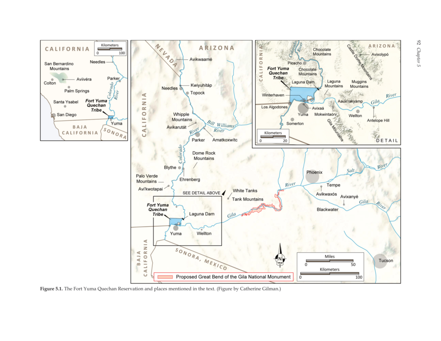
Mapa 2016

The Fort Yuma Reservation and Places Mentioned in the Text

  • AARON WRIGHT AND MAREN HOPKINS

Publicado: 2016

  • Descargar Imágen
  • Descargar Imágen
Mapa 2016

The Fort Yuma Reservation and Places Mentioned in the Text

  • AARON WRIGHT AND MAREN HOPKINS

Publicado: 2016

  • Descargar Imágen

Pueblos

  • QUECHAN

Citas

Wright, Aaron M., and Maren P. Hopkins. The Great Bend of the Gila: Contemporary Native American Connections to an Ancestral Landscape. August 2016. Accessed May 25, 2021. https://www.archaeologysouthwest.org/wp-content/uploads/2016/06/gb_ethno.pdf.
  • Descargar Imágen

Artículos Relacionados

Mapa de la America meridional, desde la equinoccial hasta
     la Tierra del Fuego

Mapa de la America meridional, desde la equinoccial hasta la Tierra del Fuego

Mapa 1596
Nieuwe Caerte van het wonderbaer ende goudrijcke landt Guiana, gelegen onder de Linie Aequinoctiael tusschen Brasilien ende Péru.

Nieuwe Caerte van het wonderbaer ende goudrijcke landt Guiana, gelegen onder de Linie Aequinoctiael tusschen Brasilien ende Péru.

Mapa 1500 - 1599
Provincia del Santo Evangelio de Mexico

Provincia del Santo Evangelio de Mexico

Mapa 1500 - 1599
Carte particulière du gouvernement de Venezuela / dressée sur ce que les Espagnols en ont écrit par le Sr D'Anville

Carte particulière du gouvernement de Venezuela / dressée sur ce que les Espagnols en ont écrit par le Sr D'Anville

Mapa 1730
QUINTANA ROO

QUINTANA ROO

Mapa 2015
PUEBLOS NACIONES ORIGINARIAS EN LA ACTUALIDAD

PUEBLOS NACIONES ORIGINARIAS EN LA ACTUALIDAD

Mapa 2011
Carte Réduite des Costed de la Guyane Despuis la Riviere d'Orenoque jusqu'au Cap de Nord à l'Entrée de la Riviere des Amazones.

Carte Réduite des Costed de la Guyane Despuis la Riviere d'Orenoque jusqu'au Cap de Nord à l'Entrée de la Riviere des Amazones.

Mapa 1760
LOCALIDADES CON 40% Y MAS DE POBLACION INDIGENA Y TIPO DE MUNICIPIOS, MÉXICO, 2000

LOCALIDADES CON 40% Y MAS DE POBLACION INDIGENA Y TIPO DE MUNICIPIOS, MÉXICO, 2000

Mapa 2000

Despojos en las Américas

Un Proyecto de

University of Pennsylvania

Copyright 2024

Con el apoyo de

Mellon Foundation

Diseño y Desarrollo del Sitio

Element 84

Créditos Artísticos

Wright, Aaron M., and Maren P. Hopkins. The Great Bend of the Gila: Contemporary Native American Connections to an Ancestral Landscape. August 2016. Accessed May 25, 2021. https://www.archaeologysouthwest.org/wp-content/uploads/2016/06/gb_ethno.pdf.
Páginas del Sitio

  • Inicio
  • Explorar
  • Autores
  • Sobre
  • Arte
  • Cuerpos
  • Planes de Estudio
  • Herencia Cultural
  • Mapas
  • Territorios