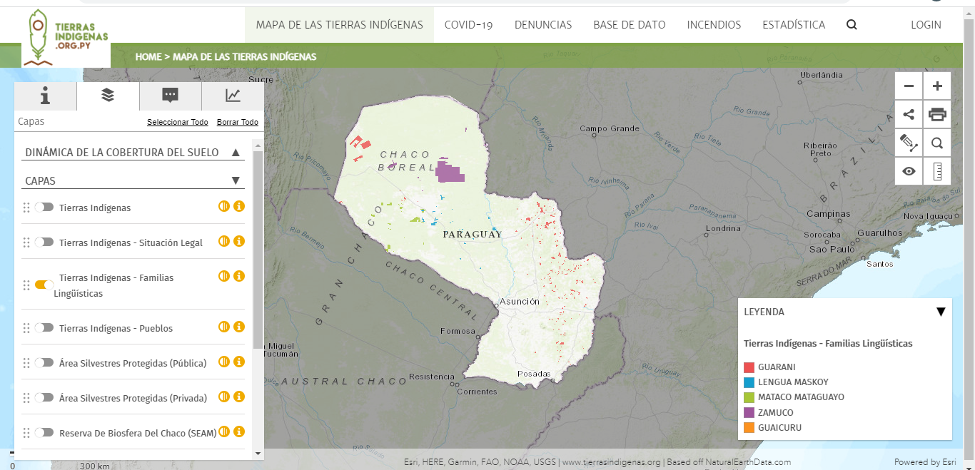
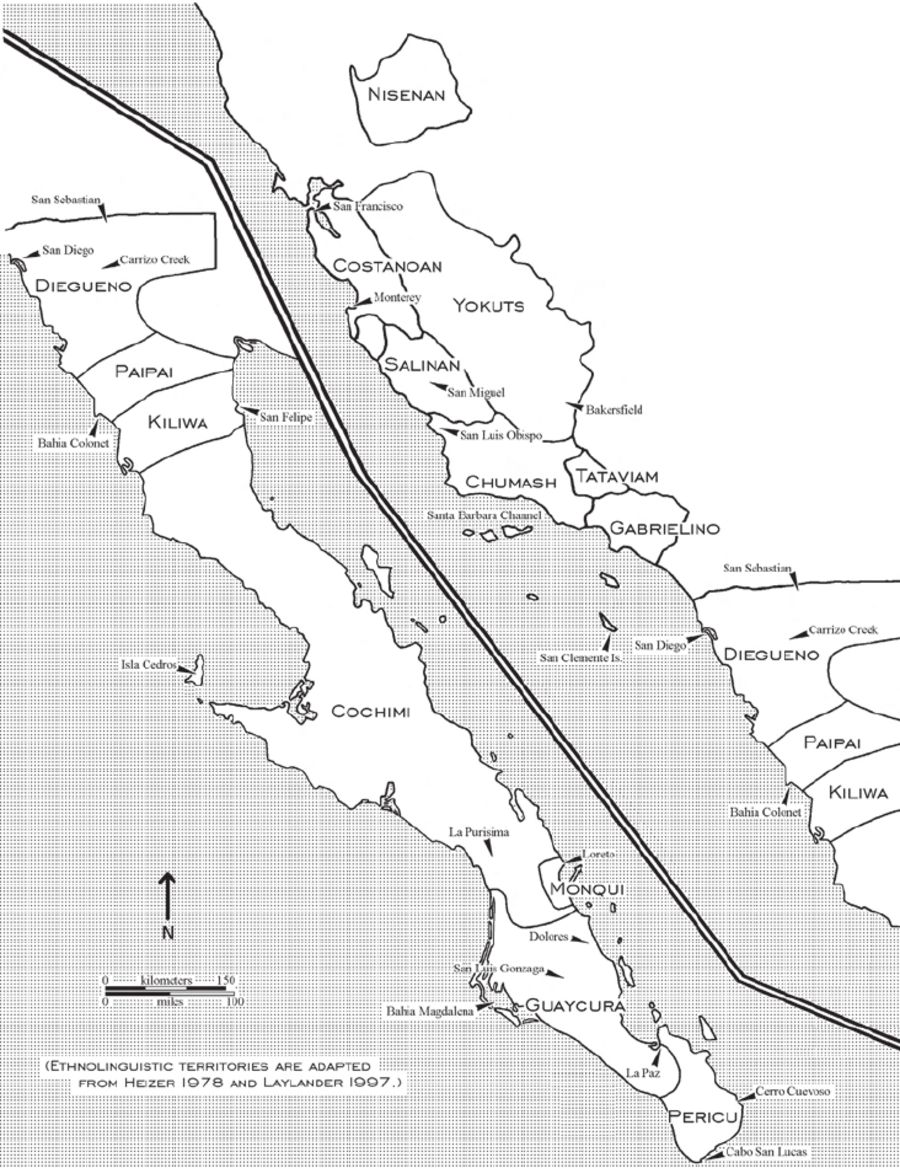
Dispossesions in the Americas

Dispossesions in the Americas

  • Inicio
  • Explorar
  • Autores
  • Sobre
  • Arte
  • Cuerpos
  • Planes de Estudio
  • Herencia Cultural
  • Mapas
  • Territorios
Volver a Explorar

Leyendo en Inglés

Mapa 2007

Ethnolinguistic territories of the Californias

  • DON LAYLANDER

Publicado: 2007

  • Descargar Imágen
  • Descargar Imágen
Mapa 2007

Ethnolinguistic territories of the Californias

  • DON LAYLANDER

Publicado: 2007

  • Descargar Imágen

Pueblos

  • PERICU
  • GUAYCURA
  • MONQUI
  • COCHIMI
  • KILIWA
  • PAIPAI
  • DIEGUENO
  • GABRIELINO
  • TATAVIAM
  • CHUMASH
  • YOKUTS
  • SALINAN
  • COSTANOAN
  • NISENAN

Citas

Laylander, Don. "Large Projectiles and the Cultural Distinction of Southern Baja California: A Reexamination." Pacific Coast Archaeological Society Quarterly 39, nos. 2 and 3 2007: 11-21. https://www.researchgate.net/publication/268024584_Large_Projectiles_and_the_Cultural_Distinction_of_Southern_Baja_California_A_Reexamination.

  • Descargar Imágen

Artículos Relacionados

Carte de la Guyane Francoise ou France Equinoxiale. Grand, beau et très fertile Pays de l'Amerique Meridionale, située entre la Riviere de Marauny et le Cap Nord

Carte de la Guyane Francoise ou France Equinoxiale. Grand, beau et très fertile Pays de l'Amerique Meridionale, située entre la Riviere de Marauny et le Cap Nord

Mapa 1763
La France. Amérique Française (Guyane). Afrique Française (Illes S.te Marie, Nossi-bé, Nossi-cumba, Nossi-fali &.).

La France. Amérique Française (Guyane). Afrique Française (Illes S.te Marie, Nossi-bé, Nossi-cumba, Nossi-fali &.).

Mapa 1869
Grupo aborigen Emberá

Grupo aborigen Emberá

Mapa
A TERRE FERME ET LE PEROU AVEC LE PAYS DES AMAZONES ET LE BRESIL

A TERRE FERME ET LE PEROU AVEC LE PAYS DES AMAZONES ET LE BRESIL

Mapa 1705
MAPA SACADO CON LA OCASION DE LA ENTRADA QUI HIZO Â SU COSTA Â LOS FERTILES Y DILATADOS PAISES DEL GRAN CHACO GUALAMBA

MAPA SACADO CON LA OCASION DE LA ENTRADA QUI HIZO Â SU COSTA Â LOS FERTILES Y DILATADOS PAISES DEL GRAN CHACO GUALAMBA

Mapa 1774
Indigenous Languages of Guatemala and British Honduras 1946

Indigenous Languages of Guatemala and British Honduras 1946

Mapa 1946
Embouchure de la Rivière des Amazones et partie de la coste de Guiane.

Embouchure de la Rivière des Amazones et partie de la coste de Guiane.

Mapa 1600 - 1699
Sketch of the country from reduction to Buenos Ayres, shewing the movements of B. Genl. Beresford, when he captured that place June 1806. Drawn from memorandums furnished by Capt: Donnelly

Sketch of the country from reduction to Buenos Ayres, shewing the movements of B. Genl. Beresford, when he captured that place June 1806. Drawn from memorandums furnished by Capt: Donnelly

Mapa 1806

Despojos en las Américas

Un Proyecto de

University of Pennsylvania

Copyright 2024

Con el apoyo de

Mellon Foundation

Diseño y Desarrollo del Sitio

Element 84

Créditos Artísticos

Laylander, Don. “Large Projectiles and the Cultural Distinction of Southern Baja California: A Reexamination.” Pacific Coast Archaeological Society Quarterly 39, nos. 2 and 3 2007: 11-21. https://www.researchgate.net/publication/268024584_Large_Projectiles_and_the_Cultural_Distinction_of_Southern_Baja_California_A_Reexamination.

Páginas del Sitio

  • Inicio
  • Explorar
  • Autores
  • Sobre
  • Arte
  • Cuerpos
  • Planes de Estudio
  • Herencia Cultural
  • Mapas
  • Territorios