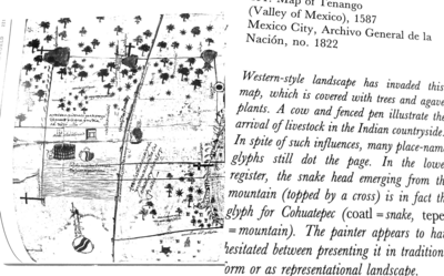
Dispossesions in the Americas

Dispossesions in the Americas

  • Inicio
  • Explorar
  • Autores
  • Sobre
  • Arte
  • Cuerpos
  • Planes de Estudio
  • Herencia Cultural
  • Mapas
  • Territorios
Volver a Explorar

Leyendo en Inglés

Mapa 1726

An exact draught of the river of Bellese as high as the Barcadares. A new draught of the bay of Honduras by Capt. Nathaniel Uring

  • URING, NATHANIEL

Publicado: 1726

  • Descargar Imágen
  • Descargar Imágen
Mapa 1726

An exact draught of the river of Bellese as high as the Barcadares. A new draught of the bay of Honduras by Capt. Nathaniel Uring

  • URING, NATHANIEL

Publicado: 1726

  • Descargar Imágen

Pueblos

  • MUSCHETO

Cita

Uring, Nathaniel. An exact draught of the river of Bellese as high as the Barcadares. A new draught of the bay of Honduras by Capt. Nathaniel Uring. Map. London, England: W. Wilkins, 1726. Accessed July 14, 2023. https://jcb.lunaimaging.com/luna/servlet/detail/JCBMAPS~1~1~4799~102886:An-exact-draught-of-the-river-of-Be?sort=normalized_date%2Cfile_name%2Csource_author%2Csource_title&qvq=q:an%20exact%20draught%20of%20the%20river;sort:normalized_date%2Cfile_name%2Csource_author%2Csource_title;lc:JCBMAPS~1~1&mi=1&trs=3.

  • Descargar Imágen

Leyendo en Portugués

Mapa 1726

An exact draught of the river of Bellese as high as the Barcadares. A new draught of the bay of Honduras by Capt. Nathaniel Uring

  • URING, NATHANIEL

Publicado: 1726

  • Descargar Imágen

Pueblos

  • MUSCHETO

Cita

Uring, Nathaniel. An exact draught of the river of Bellese as high as the Barcadares. A new draught of the bay of Honduras by Capt. Nathaniel Uring. Map. London, England: W. Wilkins, 1726. Accessed July 14, 2023. https://jcb.lunaimaging.com/luna/servlet/detail/JCBMAPS~1~1~4799~102886:An-exact-draught-of-the-river-of-Be?sort=normalized_date%2Cfile_name%2Csource_author%2Csource_title&qvq=q:an%20exact%20draught%20of%20the%20river;sort:normalized_date%2Cfile_name%2Csource_author%2Csource_title;lc:JCBMAPS~1~1&mi=1&trs=3.

  • Descargar Imágen

Artículos Relacionados

Carta ó Mapa Geográfico de una gran parte del Reino de N. E. [Nueva España], comprendido entre los 19 y 42 grados de latitud Septentrional y entre 249 y 289 grados de longitud del Meridiano de Tenerife, formado de orden del Exc[elentísi]mo S[eño]r B[eilí]o Fr[ey] D[o]n Ant[oni]o Maria Bucarely y Vrsúa p[ar]a indicar la division del Virreinato de México y de las Provincias internas erigidas en Comandancia General en virtud de Reales Órdenes el año 1770

Carta ó Mapa Geográfico de una gran parte del Reino de N. E. [Nueva España], comprendido entre los 19 y 42 grados de latitud Septentrional y entre 249 y 289 grados de longitud del Meridiano de Tenerife, formado de orden del Exc[elentísi]mo S[eño]r B[eilí]o Fr[ey] D[o]n Ant[oni]o Maria Bucarely y Vrsúa p[ar]a indicar la division del Virreinato de México y de las Provincias internas erigidas en Comandancia General en virtud de Reales Órdenes el año 1770

Mapa 1770
Map of Tenango (Valley of Mexico), 1587, Archivo General de la Nación, no. 1822

Map of Tenango (Valley of Mexico), 1587, Archivo General de la Nación, no. 1822

Mapa 1587
La Costa: el área cultural barbacoa.

La Costa: el área cultural barbacoa.

Mapa 1997
Croquis IV. La región litoral ecuatoriana (Moreno Yanez;1989;2)

Croquis IV. La región litoral ecuatoriana (Moreno Yanez;1989;2)

Mapa -500 - 1530
Missiones;quas Provincia Societatis Jesu Paraquarica excolit ad flumina Parana et Urugvay ex natione Guaranica accurate delineatice a quodam ejusdem Missionario Veterano;anno 1744

Missiones;quas Provincia Societatis Jesu Paraquarica excolit ad flumina Parana et Urugvay ex natione Guaranica accurate delineatice a quodam ejusdem Missionario Veterano;anno 1744

Mapa 1744
PUEBLO TLAHUICA

PUEBLO TLAHUICA

Mapa 2020
El mapa de los pueblos indígenas de Bolivia

El mapa de los pueblos indígenas de Bolivia

Mapa 2007
SOUTHERN BRAZIL

SOUTHERN BRAZIL

Mapa 2018

Despojos en las Américas

Un Proyecto de

University of Pennsylvania

Copyright 2024

Con el apoyo de

Mellon Foundation

Diseño y Desarrollo del Sitio

Element 84

Créditos Artísticos

Uring, Nathaniel. An exact draught of the river of Bellese as high as the Barcadares. A new draught of the bay of Honduras by Capt. Nathaniel Uring. Map. London, England: W. Wilkins, 1726. Accessed July 14, 2023. https://jcb.lunaimaging.com/luna/servlet/detail/JCBMAPS~1~1~4799~102886:An-exact-draught-of-the-river-of-Be?sort=normalized_date%2Cfile_name%2Csource_author%2Csource_title&qvq=q:an%20exact%20draught%20of%20the%20river;sort:normalized_date%2Cfile_name%2Csource_author%2Csource_title;lc:JCBMAPS~1~1&mi=1&trs=3.

Páginas del Sitio

  • Inicio
  • Explorar
  • Autores
  • Sobre
  • Arte
  • Cuerpos
  • Planes de Estudio
  • Herencia Cultural
  • Mapas
  • Territorios