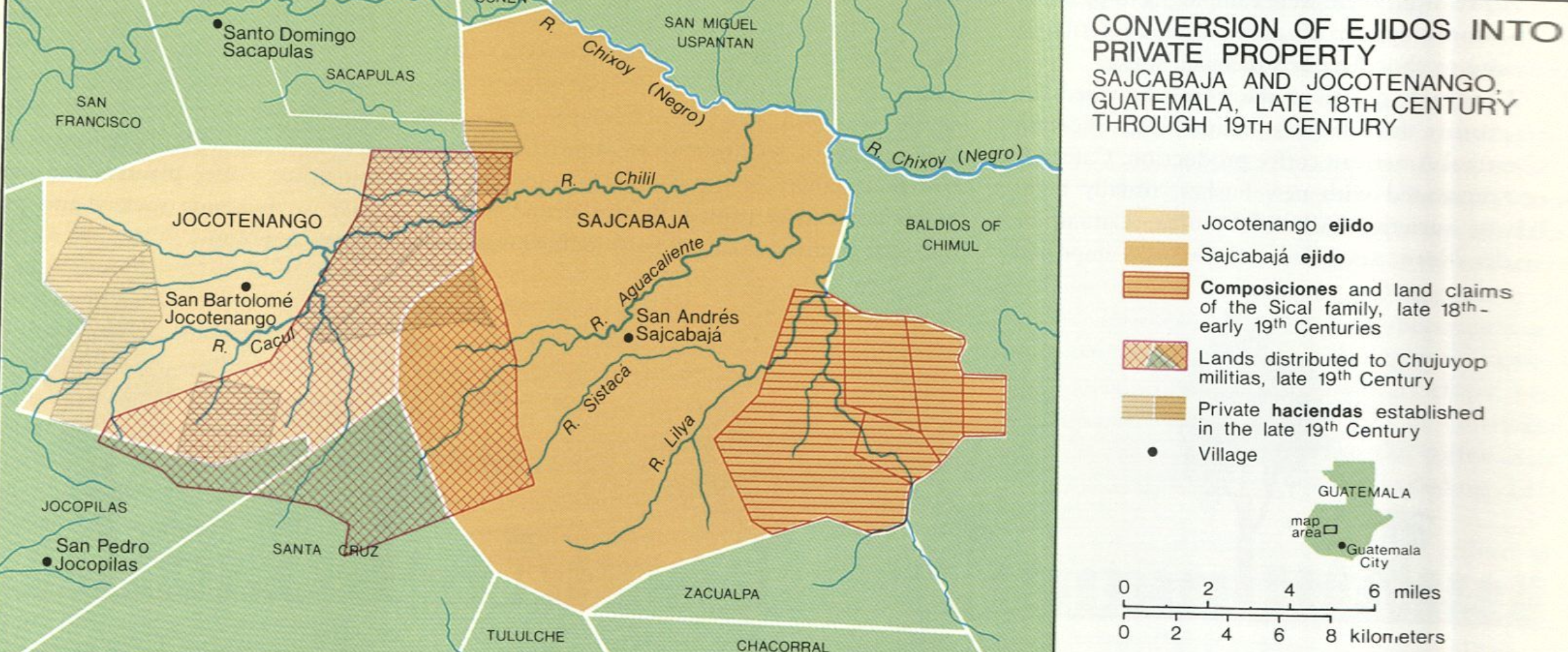
Dispossesions in the Americas

Dispossesions in the Americas

  • Inicio
  • Explorar
  • Autores
  • Sobre
  • Arte
  • Cuerpos
  • Planes de Estudio
  • Herencia Cultural
  • Mapas
  • Territorios
Volver a Explorar

Leyendo en Inglés

Mapa 1700 - 1800

Conversion of Ejidos into Private Property, Sajcabaja and Jocotenango, Guatemala, Late 18th Century through 19th Century

    Publicado: 2005

    • Descargar Imágen
    • Descargar Imágen
    Mapa 1700 - 1800

    Conversion of Ejidos into Private Property, Sajcabaja and Jocotenango, Guatemala, Late 18th Century through 19th Century

      Publicado: 2005

      • Descargar Imágen

      Cita

      "Conversion of Ejidos into Private Property, Sajcabaja and Jocotenango, Guatemala, Late 18th Century through 19th Century" IN Historical Atlas of Central America by Carolyn Hall and Héctor Pérez Brignoli. PG. 196. University of Oklhoma Press, 2005.

      • Descargar Imágen

      Leyendo en Portugués

      Mapa 1700 - 1800

      Conversion of Ejidos into Private Property, Sajcabaja and Jocotenango, Guatemala, Late 18th Century through 19th Century

        Publicado: 2005

        • Descargar Imágen

        Cita

        "Conversion of Ejidos into Private Property, Sajcabaja and Jocotenango, Guatemala, Late 18th Century through 19th Century" IN Historical Atlas of Central America by Carolyn Hall and Héctor Pérez Brignoli. PG. 196. University of Oklhoma Press, 2005.

        • Descargar Imágen

        Artículos Relacionados

        Location of the main settlements on the Lenca-Chortí-Nahua-Pipil frontier, 1530-1539. (Taken from Lara-Pinto 2009 with modifications.)

        Location of the main settlements on the Lenca-Chortí-Nahua-Pipil frontier, 1530-1539. (Taken from Lara-Pinto 2009 with modifications.)

        Mapa 1530 - 1539
        Indigenous Groups of the Caribbean

        Indigenous Groups of the Caribbean

        Mapa
        Mapa de costa comprendida entre Trujillo (Honduras) y la desembocadura del río de Matina.

        Mapa de costa comprendida entre Trujillo (Honduras) y la desembocadura del río de Matina.

        Mapa 1768
        Las etnias de Tierra del Fuego antes de su extinción

        Las etnias de Tierra del Fuego antes de su extinción

        Mapa 1800
        PUEBLO ZOQUE

        PUEBLO ZOQUE

        Mapa 2020
        Pueblos Indígenas en Paraguay

        Pueblos Indígenas en Paraguay

        Mapa 2009
        Terra Indígena Vale do Javarí

        Terra Indígena Vale do Javarí

        Mapa 2000 - 2099
        PUEBLO OCAINA

        PUEBLO OCAINA

        Mapa 2021

        Despojos en las Américas

        Un Proyecto de

        University of Pennsylvania

        Copyright 2024

        Con el apoyo de

        Mellon Foundation

        Diseño y Desarrollo del Sitio

        Element 84

        Créditos Artísticos

        “Conversion of Ejidos into Private Property, Sajcabaja and Jocotenango, Guatemala, Late 18th Century through 19th Century” IN Historical Atlas of Central America by Carolyn Hall and Héctor Pérez Brignoli. PG. 196. University of Oklhoma Press, 2005.

        Páginas del Sitio

        • Inicio
        • Explorar
        • Autores
        • Sobre
        • Arte
        • Cuerpos
        • Planes de Estudio
        • Herencia Cultural
        • Mapas
        • Territorios