Dispossesions in the Americas

Dispossesions in the Americas

  • Inicio
  • Explorar
  • Autores
  • Sobre
  • Arte
  • Cuerpos
  • Planes de Estudio
  • Herencia Cultural
  • Mapas
  • Territorios
Volver a Explorar

Leyendo en Inglés

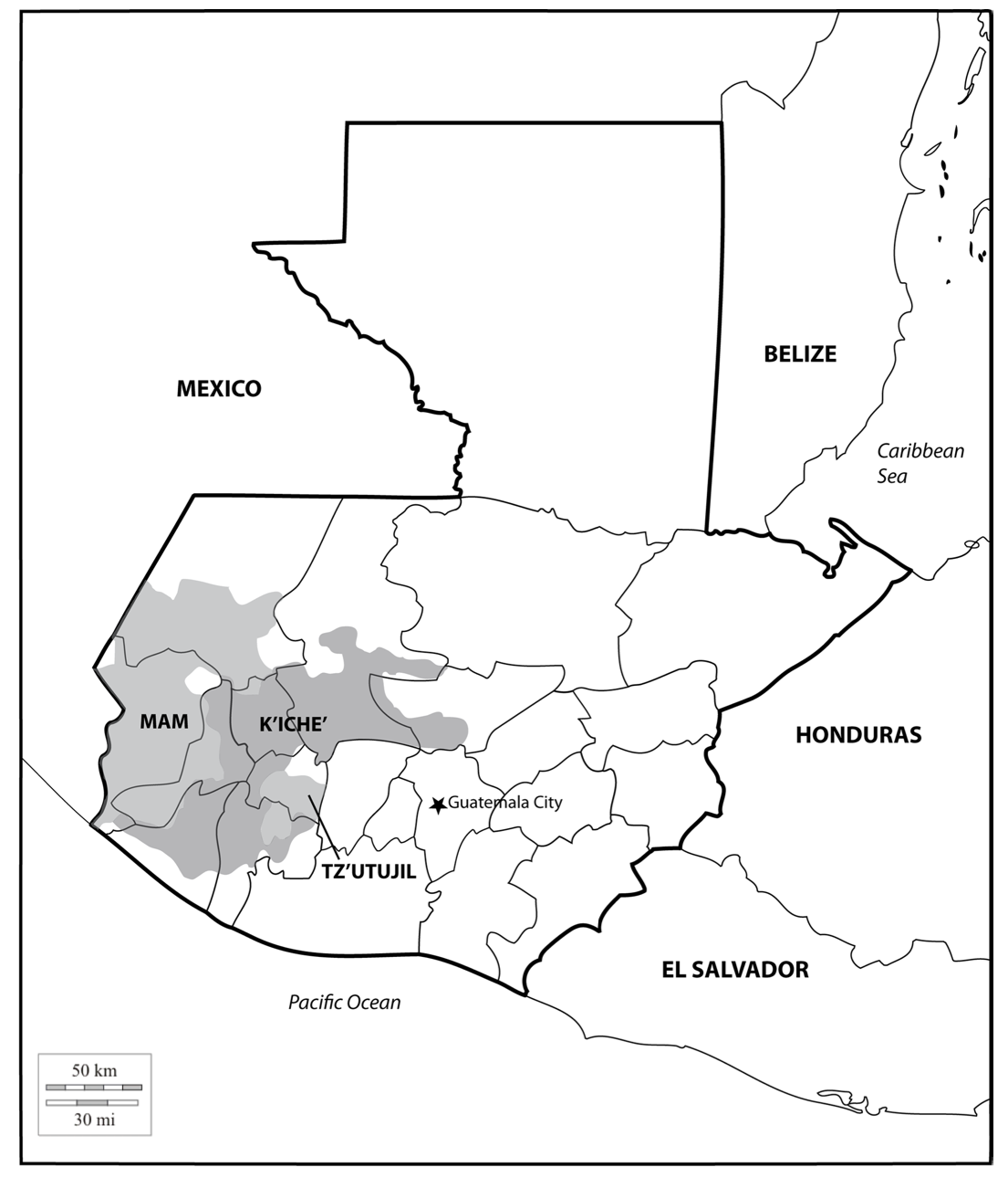
Mapa 2000

Location of three ethno-linguistic groups in the highlands of Guatemala in which joint InHerit-Riecken community-participant mapping took place. Adapted from http://d-maps. com/carte.php?num_car=1717&lang=en)

  • MCANANAY, ROWE;CHOLOTIO;MENCHU;QUIC

Publicado: 2015

  • Descargar Imágen
  • Descargar Imágen
Mapa 2000

Location of three ethno-linguistic groups in the highlands of Guatemala in which joint InHerit-Riecken community-participant mapping took place. Adapted from http://d-maps. com/carte.php?num_car=1717&lang=en)

  • MCANANAY, ROWE;CHOLOTIO;MENCHU;QUIC

Publicado: 2015

  • Descargar Imágen

Pueblos

  • MAM
  • K'ICHE'
  • TZ'UTUJIL

Citas

McAnany, P. A., Rowe, S. M., Cholotio, I. Q., Menchu, E. C., & Quic, J. M. (2015). Mapping indigenous self-determination in highland guatemala. International Journal of Applied Geospatial Research, 6(1), 1-23. doi: https://doi.org/10.4018/ijagr.2015010101
  • Descargar Imágen

Artículos Relacionados

RESGUARDOS Y TERRITORIOS INDIGENAS EN COLOMBIA

RESGUARDOS Y TERRITORIOS INDIGENAS EN COLOMBIA

Mapa 2015
Aché

Aché

Mapa 2001
MAPA 1. TERRITORIO WAORANI;GRUPOS TAGAERI;TAROMENANE Y BLOQUES PETROLEROS EN EL YASUNÍ

MAPA 1. TERRITORIO WAORANI;GRUPOS TAGAERI;TAROMENANE Y BLOQUES PETROLEROS EN EL YASUNÍ

Mapa 2013
PUEBLO RESÍGARO

PUEBLO RESÍGARO

Mapa 2021
PUEBLO NAHUA DE TLAXCALA

PUEBLO NAHUA DE TLAXCALA

Mapa 2020
Le Perou dans l'Amerique Meridionale Dresse sur les divers relations des filibustiers et nouveaux voyageurs

Le Perou dans l'Amerique Meridionale Dresse sur les divers relations des filibustiers et nouveaux voyageurs

Mapa 1719
CARTE DU PEROU DU FLEUVE DES AMAZONES ET DU BRESIL

CARTE DU PEROU DU FLEUVE DES AMAZONES ET DU BRESIL

Mapa 1700 - 1799
Mapa histórico-geográfico de Perú, Chile y Buenos Aires

Mapa histórico-geográfico de Perú, Chile y Buenos Aires

Mapa 1830

Despojos en las Américas

Un Proyecto de

University of Pennsylvania

Copyright 2024

Con el apoyo de

Mellon Foundation

Diseño y Desarrollo del Sitio

Element 84

Créditos Artísticos

McAnany, P. A., Rowe, S. M., Cholotio, I. Q., Menchu, E. C., & Quic, J. M. (2015). Mapping indigenous self-determination in highland guatemala. International Journal of Applied Geospatial Research, 6(1), 1-23. doi: https://doi.org/10.4018/ijagr.2015010101
Páginas del Sitio

  • Inicio
  • Explorar
  • Autores
  • Sobre
  • Arte
  • Cuerpos
  • Planes de Estudio
  • Herencia Cultural
  • Mapas
  • Territorios