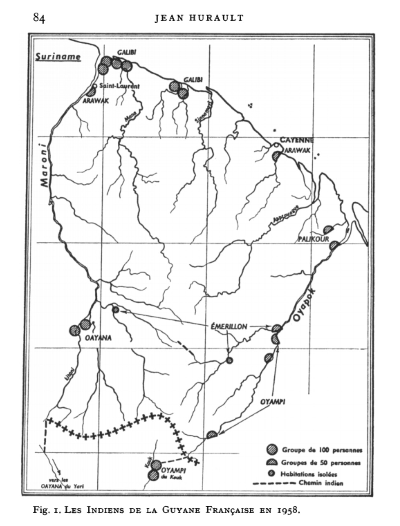
Dispossesions in the Americas

Dispossesions in the Americas

  • Inicio
  • Explorar
  • Autores
  • Sobre
  • Arte
  • Cuerpos
  • Planes de Estudio
  • Herencia Cultural
  • Mapas
  • Territorios
Volver a Explorar

Leyendo en Inglés

Mapa 1958

Fig. 1. Les Indiens de la Guyane Française en 1958

  • HURAULT, JEAN

Publicado: 1962

  • Descargar Imágen
  • Descargar Imágen
Mapa 1958

Fig. 1. Les Indiens de la Guyane Française en 1958

  • HURAULT, JEAN

Publicado: 1962

  • Descargar Imágen

Pueblos

  • ARAWAK
  • EMERILLON
  • GALIBI
  • OAYANA
  • OYAMPI
  • PALIKOUR

Cita

Hurault, Jean. “Les indiens de Guyane Française: Problèmes pratiques d'administration et de contacts de civilisation.” Nieuwe West-Indische Gids / New West Indian Guide 42 (1962): 81–186. http://www.jstor.org/stable/41849385.

  • Descargar Imágen

Leyendo en Portugués

Mapa 1958

Fig. 1. Les Indiens de la Guyane Française en 1958

  • HURAULT, JEAN

Publicado: 1962

  • Descargar Imágen

Pueblos

  • ARAWAK
  • EMERILLON
  • GALIBI
  • OAYANA
  • OYAMPI
  • PALIKOUR

Cita

Hurault, Jean. “Les indiens de Guyane Française: Problèmes pratiques d'administration et de contacts de civilisation.” Nieuwe West-Indische Gids / New West Indian Guide 42 (1962): 81–186. http://www.jstor.org/stable/41849385.

  • Descargar Imágen

Artículos Relacionados

Mapa del Corregimiento de Tecpanatitlan

Mapa del Corregimiento de Tecpanatitlan

Mapa 1690
PERÚ: COMUNIDADES NATIVAS CENSADAS POR PUEBLO INDÍGENA U ORIGINARIO A LOS QUE HAN DECLARADO PERTENECER, 2017

PERÚ: COMUNIDADES NATIVAS CENSADAS POR PUEBLO INDÍGENA U ORIGINARIO A LOS QUE HAN DECLARADO PERTENECER, 2017

Mapa 2017
Linguistic Map of Southern Mexican Highlands and Adjacent Regions at Contact Period

Linguistic Map of Southern Mexican Highlands and Adjacent Regions at Contact Period

Mapa 1969
A Description of the Plantations in the Valley of Paneca

A Description of the Plantations in the Valley of Paneca

Mapa
Map of the Republic of Guatemala

Map of the Republic of Guatemala

Mapa 1800
FRAGMENTO HUMBOLDT 2

FRAGMENTO HUMBOLDT 2

Mapa 1500 - 1599
Mapa Histórico - Étnico de los Indios Abipones

Mapa Histórico - Étnico de los Indios Abipones

Mapa 1600 - 1885
Map of Tenango (Valley of Mexico), 1587, Archivo General de la Nación, no. 1822

Map of Tenango (Valley of Mexico), 1587, Archivo General de la Nación, no. 1822

Mapa 1587

Despojos en las Américas

Un Proyecto de

University of Pennsylvania

Copyright 2024

Con el apoyo de

Mellon Foundation

Diseño y Desarrollo del Sitio

Element 84

Créditos Artísticos

Hurault, Jean. “Les indiens de Guyane Française: Problèmes pratiques d’administration et de contacts de civilisation.” Nieuwe West-Indische Gids / New West Indian Guide 42 (1962): 81–186. http://www.jstor.org/stable/41849385.

Páginas del Sitio

  • Inicio
  • Explorar
  • Autores
  • Sobre
  • Arte
  • Cuerpos
  • Planes de Estudio
  • Herencia Cultural
  • Mapas
  • Territorios