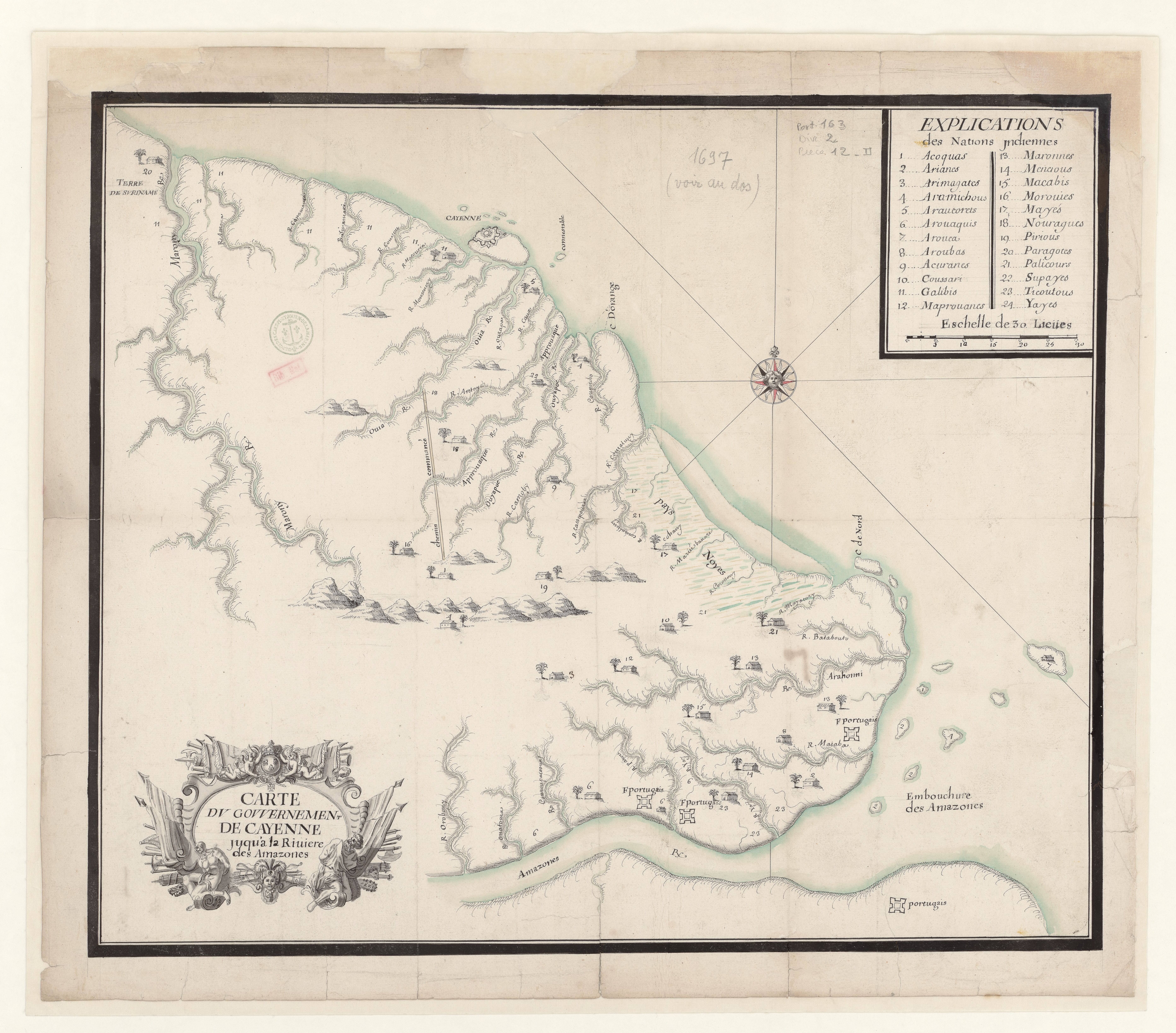
Dispossesions in the Americas

Dispossesions in the Americas

  • Inicio
  • Explorar
  • Autores
  • Sobre
  • Arte
  • Cuerpos
  • Planes de Estudio
  • Herencia Cultural
  • Mapas
  • Territorios
Volver a Explorar

Leyendo en Inglés

Mapa 1697

Carte du gouvernement de Cayenne jusqu'à la rivière des Amazones.

    Publicado: 1697

    • Descargar Imágen
    • Descargar Imágen
    Mapa 1697

    Carte du gouvernement de Cayenne jusqu'à la rivière des Amazones.

      Publicado: 1697

      • Descargar Imágen

      Pueblos

      • ACOQUAS
      • ARIANES
      • ARIMAGATES
      • ARAMICHOUS
      • ARAUCORETS
      • AROUAQUIS
      • AROUCA
      • AROUBAS
      • ACURANES
      • COUSSARI
      • GALIBIS
      • MAPROUANES
      • MARONNES
      • MENAOUS
      • MACABIS
      • MOROUIES
      • MAYES
      • NOURAGUES
      • PIRIOUS
      • PARAGOTES
      • PALICOURS
      • SUPAYES
      • TICOUTOUS
      • YAYES

      Citas

      Carte du gouvernement de Cayenne jusqu'à la rivière des Amazones. Gallica. Last modified: September 21, 2015. Accessed, July 8, 2023. https://gallica.bnf.fr/ark:/12148/btv1b53103830s

      • Descargar Imágen

      Artículos Relacionados

      HIDALGO

      HIDALGO

      Mapa 2015
      The modern departments of Ahuachapán, La Libertad, Santa Ana, and Sonsonate (highlighted in red) now contain the highest concentration of Indigenous communities in El Salvador.

      The modern departments of Ahuachapán, La Libertad, Santa Ana, and Sonsonate (highlighted in red) now contain the highest concentration of Indigenous communities in El Salvador.

      Mapa 2010
      Le Paraguay

      Le Paraguay

      Mapa 1733
      No Title

      No Title

      Mapa -2500 - 1520
      of Amerindians

      of Amerindians

      Mapa
      This is a description of the Isle of Pines and Golden Island / William Hacke

      This is a description of the Isle of Pines and Golden Island / William Hacke

      Mapa 1688
      Areas culturales de los pueblos indígenas del Ecuador

      Areas culturales de los pueblos indígenas del Ecuador

      Mapa 1997
      PERÚ: COMUNIDADES NATIVAS CENSADAS POR PUEBLO INDÍGENA U ORIGINARIO A LOS QUE HAN DECLARADO PERTENECER, 2017

      PERÚ: COMUNIDADES NATIVAS CENSADAS POR PUEBLO INDÍGENA U ORIGINARIO A LOS QUE HAN DECLARADO PERTENECER, 2017

      Mapa 2017

      Despojos en las Américas

      Un Proyecto de

      University of Pennsylvania

      Copyright 2024

      Con el apoyo de

      Mellon Foundation

      Diseño y Desarrollo del Sitio

      Element 84

      Créditos Artísticos

      Carte du gouvernement de Cayenne jusqu’à la rivière des Amazones. Gallica. Last modified: September 21, 2015. Accessed, July 8, 2023. https://gallica.bnf.fr/ark:/12148/btv1b53103830s

      Páginas del Sitio

      • Inicio
      • Explorar
      • Autores
      • Sobre
      • Arte
      • Cuerpos
      • Planes de Estudio
      • Herencia Cultural
      • Mapas
      • Territorios