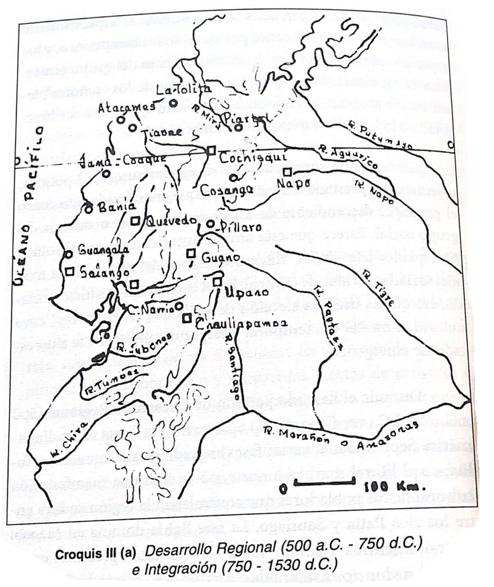
Dispossesions in the Americas

Dispossesions in the Americas

  • Inicio
  • Explorar
  • Autores
  • Sobre
  • Arte
  • Cuerpos
  • Planes de Estudio
  • Herencia Cultural
  • Mapas
  • Territorios
Volver a Explorar

Leyendo en Inglés

Mapa -500 - 1530

Croquis III. (a) Desarrollo Regional (500 a.C -750 d.C) e Integración (750-1530 a.C.)

  • SEGUNDO E. MORENO YANEZ

Publicado: 1989

  • Descargar Imágen
  • Descargar Imágen
Mapa -500 - 1530

Croquis III. (a) Desarrollo Regional (500 a.C -750 d.C) e Integración (750-1530 a.C.)

  • SEGUNDO E. MORENO YANEZ

Publicado: 1989

  • Descargar Imágen

Pueblos

  • LA TOLITA
  • ATACAMES
  • JAMA COAQUE
  • COCHISQUI
  • PILLARO
  • GUANGALA
  • NARRIO
  • UPANO
  • NAPO
  • SALANGO

Cita

Borchart de Moreno;Christiana Renate;and Segundo. Moreno Yáñez. Crónica indiana del Ecuador antiguo. Quito: Proyecto EBI-GTZ;1997. https://upenn.alma.exlibrisgroup.com/discovery/fulldisplay?vid=01UPENN_INST:Services&id=9923438013503681&inst=01UPENN_INST&context=L

  • Descargar Imágen

Leyendo en Portugués

Mapa -500 - 1530

Croquis III. (a) Desarrollo Regional (500 a.C -750 d.C) e Integración (750-1530 a.C.)

  • SEGUNDO E. MORENO YANEZ

Publicado: 1989

  • Descargar Imágen

Pueblos

  • LA TOLITA
  • ATACAMES
  • JAMA COAQUE
  • COCHISQUI
  • PILLARO
  • GUANGALA
  • NARRIO
  • UPANO
  • NAPO
  • SALANGO

Cita

Borchart de Moreno;Christiana Renate;and Segundo. Moreno Yáñez. Crónica indiana del Ecuador antiguo. Quito: Proyecto EBI-GTZ;1997. https://upenn.alma.exlibrisgroup.com/discovery/fulldisplay?vid=01UPENN_INST:Services&id=9923438013503681&inst=01UPENN_INST&context=L

  • Descargar Imágen

Artículos Relacionados

VENEZUELA

VENEZUELA

Mapa 1878
MULTI-ETHNIC TERRITORY under INCA DIRECT RULE: THE CENTRAL AND UPPER VALLEYS OF COCHABAMBA in the 1530s

MULTI-ETHNIC TERRITORY under INCA DIRECT RULE: THE CENTRAL AND UPPER VALLEYS OF COCHABAMBA in the 1530s

Mapa 1520
The Island and Colony of Cayenne subject to the French, on the Continent of South America.

The Island and Colony of Cayenne subject to the French, on the Continent of South America.

Mapa 1760
MAPA DE SIGUENZA/MAP OF SIGUENZA

MAPA DE SIGUENZA/MAP OF SIGUENZA

Mapa 1500 - 1599
RETAL IXIMULEW Mapa Lingüístico de Guatemala Idiomas mayas, xinka y garífuna

RETAL IXIMULEW Mapa Lingüístico de Guatemala Idiomas mayas, xinka y garífuna

Mapa 1994
PUEBLO QATO'K

PUEBLO QATO'K

Mapa 2020
Mosquitia or The Mosquito Shore with The Eastern Part of Yucatán as far as the 20th Degree of North Latitude

Mosquitia or The Mosquito Shore with The Eastern Part of Yucatán as far as the 20th Degree of North Latitude

Mapa 1787
AMERICA MERIDIONIALE

AMERICA MERIDIONIALE

Mapa 1770

Despojos en las Américas

Un Proyecto de

University of Pennsylvania

Copyright 2024

Con el apoyo de

Mellon Foundation

Diseño y Desarrollo del Sitio

Element 84

Créditos Artísticos

Borchart de Moreno;Christiana Renate;and Segundo. Moreno Yáñez. Crónica indiana del Ecuador antiguo. Quito: Proyecto EBI-GTZ;1997. https://upenn.alma.exlibrisgroup.com/discovery/fulldisplay?vid=01UPENN_INST:Services&id=9923438013503681&inst=01UPENN_INST&context=L

Páginas del Sitio

  • Inicio
  • Explorar
  • Autores
  • Sobre
  • Arte
  • Cuerpos
  • Planes de Estudio
  • Herencia Cultural
  • Mapas
  • Territorios