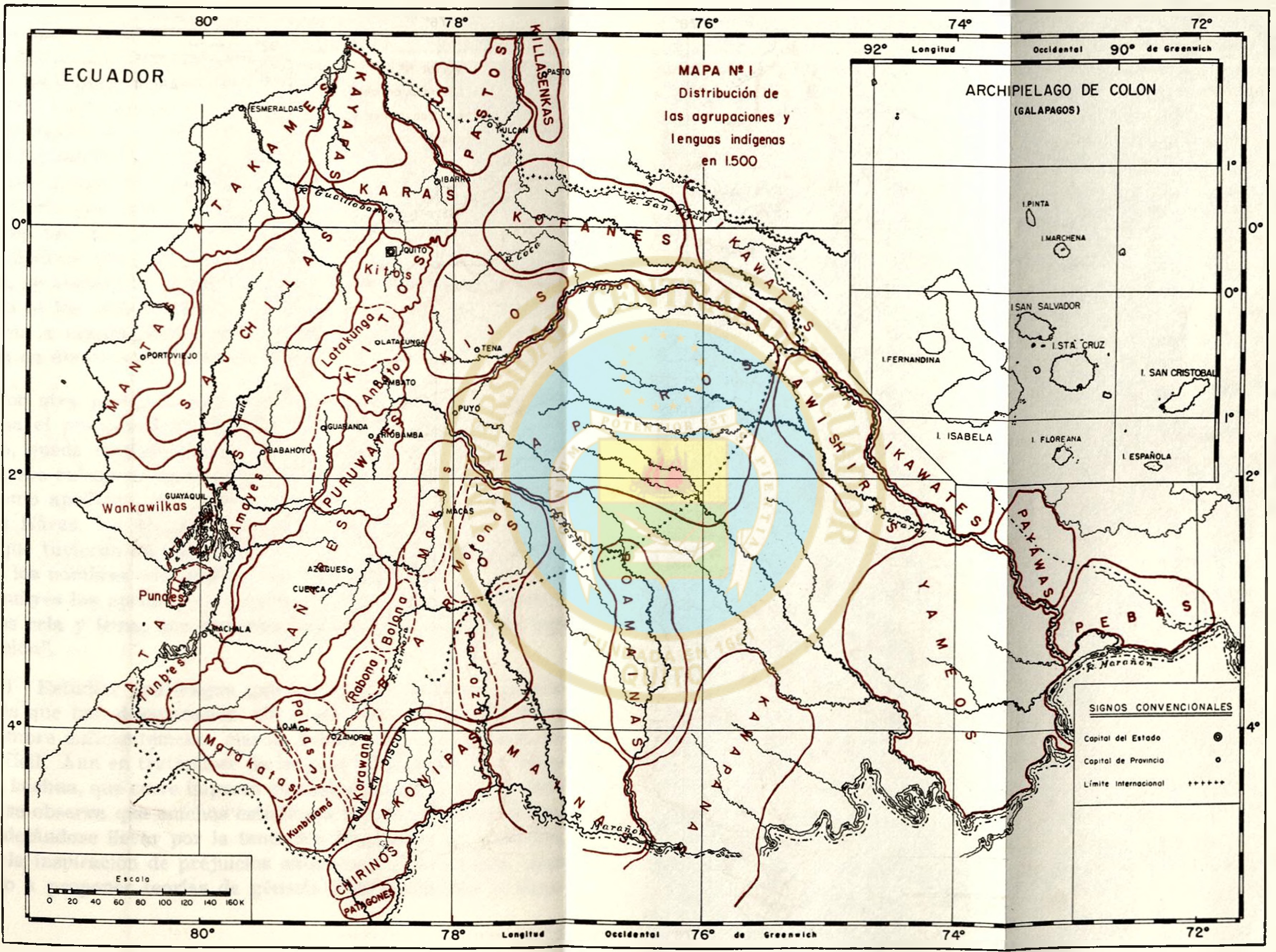
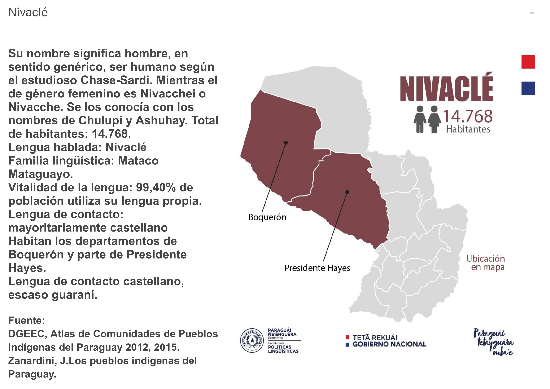
Dispossesions in the Americas

Dispossesions in the Americas

  • Inicio
  • Explorar
  • Autores
  • Sobre
  • Arte
  • Cuerpos
  • Planes de Estudio
  • Herencia Cultural
  • Mapas
  • Territorios
Volver a Explorar

Leyendo en Inglés

Mapa 1500

MAPA N. 1 DISTRIBUCIÓN DE LAS AGRUPACIONES Y LENGUAS INDÍGENAS EN 1500

  • LUIS PAZ Y MINO

Publicado: 1961

  • Descargar Imágen
  • Descargar Imágen
Mapa 1500

MAPA N. 1 DISTRIBUCIÓN DE LAS AGRUPACIONES Y LENGUAS INDÍGENAS EN 1500

  • LUIS PAZ Y MINO

Publicado: 1961

  • Descargar Imágen

Pueblos

  • ATAKAMES
  • KAYAPAS
  • KARAS
  • PASTO
  • KILLASENKA
  • COFAN
  • IKAWATE
  • KIJOS
  • KITU KARA
  • SAPARA
  • MANTA
  • TSACHILA
  • HUANCAVILCA
  • PURUWA
  • QUECHUA
  • KANARI
  • PUNA
  • PALTA
  • MAINA

Cita

Paz y Miño;Luis. “Estudios Sobre La Prehistoria Ecuatoriana.” Repositorio Digital: Estudios sobre la prehistoria ecuatoriana. Quito: Industrias Gráficas CYMA;January 1;1961. http://www.dspace.uce.edu.ec/handle/25000/17994.

  • Descargar Imágen

Leyendo en Portugués

Mapa 1500

MAPA N. 1 DISTRIBUCIÓN DE LAS AGRUPACIONES Y LENGUAS INDÍGENAS EN 1500

  • LUIS PAZ Y MINO

Publicado: 1961

  • Descargar Imágen

Pueblos

  • ATAKAMES
  • KAYAPAS
  • KARAS
  • PASTO
  • KILLASENKA
  • COFAN
  • IKAWATE
  • KIJOS
  • KITU KARA
  • SAPARA
  • MANTA
  • TSACHILA
  • HUANCAVILCA
  • PURUWA
  • QUECHUA
  • KANARI
  • PUNA
  • PALTA
  • MAINA

Cita

Paz y Miño;Luis. “Estudios Sobre La Prehistoria Ecuatoriana.” Repositorio Digital: Estudios sobre la prehistoria ecuatoriana. Quito: Industrias Gráficas CYMA;January 1;1961. http://www.dspace.uce.edu.ec/handle/25000/17994.

  • Descargar Imágen

Artículos Relacionados

PROVINCIA DO MARANHAO

PROVINCIA DO MARANHAO

Mapa 1800 - 1850
AMERICA MERIDIONIALE

AMERICA MERIDIONIALE

Mapa 1770
TERRITORIO DE YUKPA DE PERIJA

TERRITORIO DE YUKPA DE PERIJA

Mapa 2018
NIVACLÉ

NIVACLÉ

Mapa 2015
Le Paraguay

Le Paraguay

Mapa 1600 - 1700
Carta particolare dell'India Ocidentale;con la terra ferma dal' capo di Paria sin al' capo S. Romano

Carta particolare dell'India Ocidentale;con la terra ferma dal' capo di Paria sin al' capo S. Romano

Mapa 1661
Geographic Distribution of the Zapotec, Oaxaca

Geographic Distribution of the Zapotec, Oaxaca

Mapa 1969
K. GUIANA. I. DAS BRITISCHE, II. [DAS] NIEDERLAENDISCHE, III. [DAS FRANZÖSISCHE.]

K. GUIANA. I. DAS BRITISCHE, II. [DAS] NIEDERLAENDISCHE, III. [DAS FRANZÖSISCHE.]

Mapa 1800 - 1899

Despojos en las Américas

Un Proyecto de

University of Pennsylvania

Copyright 2024

Con el apoyo de

Mellon Foundation

Diseño y Desarrollo del Sitio

Element 84

Créditos Artísticos

Paz y Miño;Luis. “Estudios Sobre La Prehistoria Ecuatoriana.” Repositorio Digital: Estudios sobre la prehistoria ecuatoriana. Quito: Industrias Gráficas CYMA;January 1;1961. http://www.dspace.uce.edu.ec/handle/25000/17994.

Páginas del Sitio

  • Inicio
  • Explorar
  • Autores
  • Sobre
  • Arte
  • Cuerpos
  • Planes de Estudio
  • Herencia Cultural
  • Mapas
  • Territorios