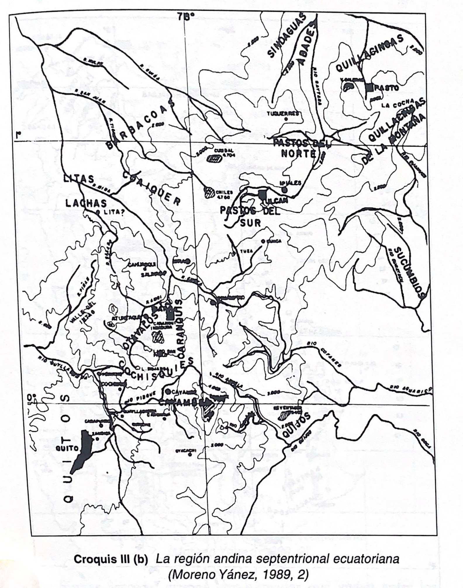
Dispossesions in the Americas

Dispossesions in the Americas

  • Inicio
  • Explorar
  • Autores
  • Sobre
  • Arte
  • Cuerpos
  • Planes de Estudio
  • Herencia Cultural
  • Mapas
  • Territorios
Volver a Explorar

Leyendo en Inglés

Mapa 1610

Mapa de la tierra donde habitan los indios, Piles Timbas y Barbacoas

    Publicado: 1610

    • Descargar Imágen
    • Descargar Imágen
    Mapa 1610

    Mapa de la tierra donde habitan los indios, Piles Timbas y Barbacoas

      Publicado: 1610

      • Descargar Imágen

      Pueblos

      • BARBACOAS
      • IUNDIGUA
      • MAPACAY
      • OMOCO
      • OROKUNAS
      • PARIPACOS
      • PILES
      • TIMBAS
      • YYAMA

      Cita

      Unauthored. Mapa de la tierra donde habitan los indios, Piles Timbas y Barbacoas. ES.41091.AGI//MP-PANAMA,30. Portal de Archivos Españoles - PARES. 1610, Accessed, October 27, 2023. http://pares.mcu.es/ParesBusquedas20/catalogo/show/22062

      • Descargar Imágen

      Leyendo en Portugués

      Mapa 1610

      Mapa de la tierra donde habitan los indios, Piles Timbas y Barbacoas

        Publicado: 1610

        • Descargar Imágen

        Pueblos

        • BARBACOAS
        • IUNDIGUA
        • MAPACAY
        • OMOCO
        • OROKUNAS
        • PARIPACOS
        • PILES
        • TIMBAS
        • YYAMA

        Cita

        Unauthored. Mapa de la tierra donde habitan los indios, Piles Timbas y Barbacoas. ES.41091.AGI//MP-PANAMA,30. Portal de Archivos Españoles - PARES. 1610, Accessed, October 27, 2023. http://pares.mcu.es/ParesBusquedas20/catalogo/show/22062

        • Descargar Imágen

        Artículos Relacionados

        A draught of the Bay of Honduras and part of the Musquetto Shore by George Robertson

        A draught of the Bay of Honduras and part of the Musquetto Shore by George Robertson

        Mapa 1766
        Costa Rica;Nicaragua;Guatemala y Honduras

        Costa Rica;Nicaragua;Guatemala y Honduras

        Mapa 1800 - 1801
        Outlines of the physical and political division of South America: Delineated by A. Arrowsmith partly from scarce and original documents, published before the year 1806 but principally from manuscript maps & surveys made between the years 1771 and 1806, corrected from accurate astronomical observations to 1810.

        Outlines of the physical and political division of South America: Delineated by A. Arrowsmith partly from scarce and original documents, published before the year 1806 but principally from manuscript maps & surveys made between the years 1771 and 1806, corrected from accurate astronomical observations to 1810.

        Mapa 1800 - 1899
        Croquis III. (b) La región andina septentrional ecuatoriana (Moreno Yanez;1989;2)

        Croquis III. (b) La región andina septentrional ecuatoriana (Moreno Yanez;1989;2)

        Mapa -500 - 1530
        IDIOMAS DE GUATEMALA Y BELICE

        IDIOMAS DE GUATEMALA Y BELICE

        Mapa
        PUEBLO Q'ANJOB'AL

        PUEBLO Q'ANJOB'AL

        Mapa 2020
        Ombre des Amazonies [Sombra de las Amazonías]

        Ombre des Amazonies [Sombra de las Amazonías]

        Obra de Arte
        Geographic Map of the Nicaragua with three plans and views.

        Geographic Map of the Nicaragua with three plans and views.

        Mapa 1855

        Despojos en las Américas

        Un Proyecto de

        University of Pennsylvania

        Copyright 2024

        Con el apoyo de

        Mellon Foundation

        Diseño y Desarrollo del Sitio

        Element 84

        Créditos Artísticos

        Unauthored. Mapa de la tierra donde habitan los indios, Piles Timbas y Barbacoas. ES.41091.AGI//MP-PANAMA,30. Portal de Archivos Españoles - PARES. 1610, Accessed, October 27, 2023. http://pares.mcu.es/ParesBusquedas20/catalogo/show/22062

        Páginas del Sitio

        • Inicio
        • Explorar
        • Autores
        • Sobre
        • Arte
        • Cuerpos
        • Planes de Estudio
        • Herencia Cultural
        • Mapas
        • Territorios