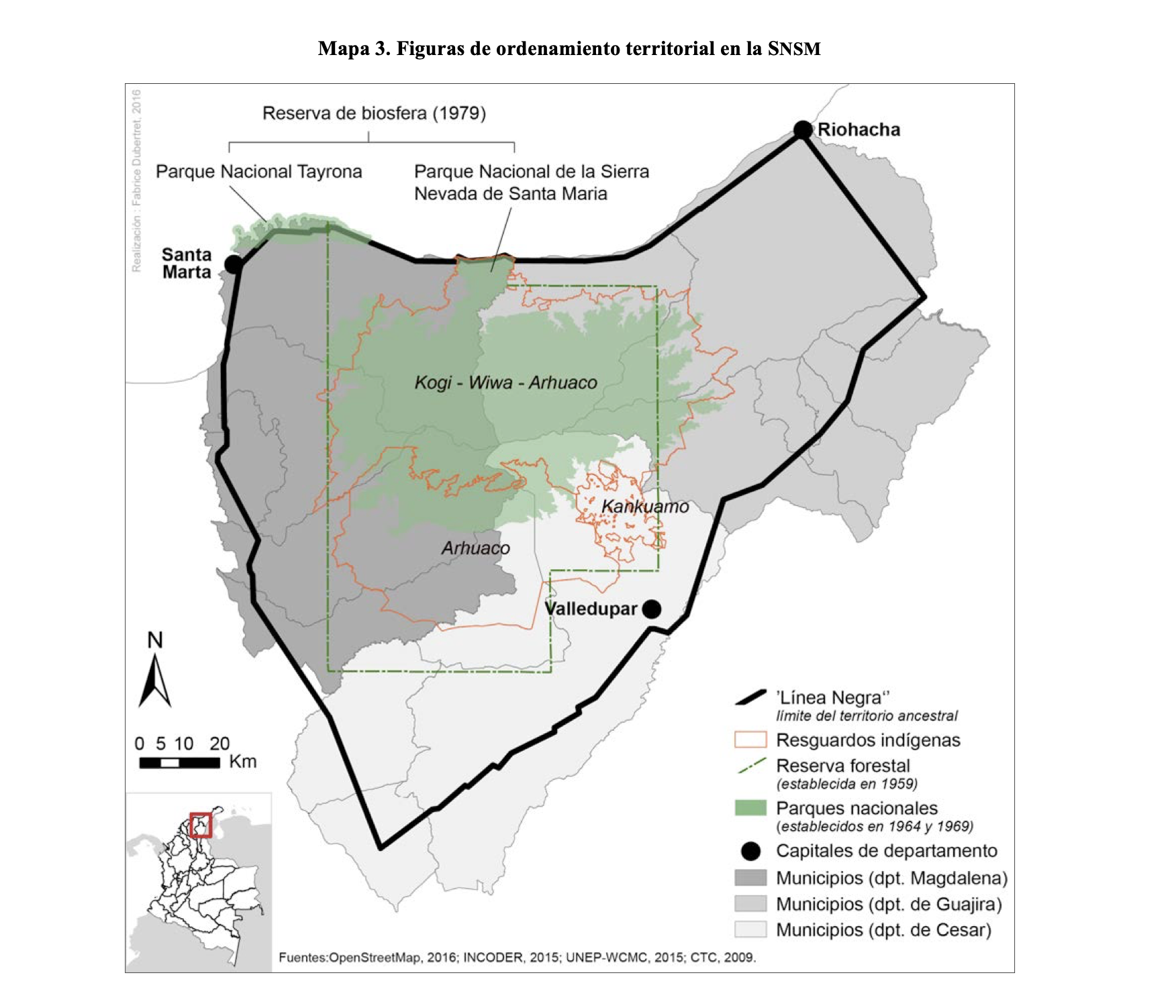
Dispossesions in the Americas

Dispossesions in the Americas

  • Inicio
  • Explorar
  • Autores
  • Sobre
  • Arte
  • Cuerpos
  • Planes de Estudio
  • Herencia Cultural
  • Mapas
  • Territorios
Volver a Explorar

Leyendo en Inglés

Mapa 1700 - 1799

The Caribee Islands and Guyana.

  • Delarochette, L.;Jefferys, Thomas

Publicado: 1769

  • Descargar Imágen
  • Descargar Imágen
Mapa 1700 - 1799

The Caribee Islands and Guyana.

  • Delarochette, L.;Jefferys, Thomas

Publicado: 1769

  • Descargar Imágen

Pueblos

  • ARUACAS
  • CARIVAS
  • GALIBIS
  • GUARAUNOS
  • GUAYANAS
  • MERCIOUX
  • NOURAGUES
  • OUAYES
  • PALICOURS
  • QUIRQUIRIPAS

Cita

Delarochette, L., Jefferys, Thomas. The Caribee Islands and Guyana. Library of Congress. Accessed, August 3, 2023. https://www.loc.gov/resource/g3300m.gar00003/?sp=102&r=0.186,-0.019,0.645,0.328,0

  • Descargar Imágen

Leyendo en Portugués

Mapa 1700 - 1799

The Caribee Islands and Guyana.

  • Delarochette, L.;Jefferys, Thomas

Publicado: 1769

  • Descargar Imágen

Pueblos

  • ARUACAS
  • CARIVAS
  • GALIBIS
  • GUARAUNOS
  • GUAYANAS
  • MERCIOUX
  • NOURAGUES
  • OUAYES
  • PALICOURS
  • QUIRQUIRIPAS

Cita

Delarochette, L., Jefferys, Thomas. The Caribee Islands and Guyana. Library of Congress. Accessed, August 3, 2023. https://www.loc.gov/resource/g3300m.gar00003/?sp=102&r=0.186,-0.019,0.645,0.328,0

  • Descargar Imágen

Artículos Relacionados

FIGURAS DE ORDENAMIENTO TERRITORIAL EN LA SNSM

FIGURAS DE ORDENAMIENTO TERRITORIAL EN LA SNSM

Mapa 2009
Terra Indígena Itariri (Serra do Itatins)

Terra Indígena Itariri (Serra do Itatins)

Mapa 2011
Territorios Indigenas en Guatemala 2,001

Territorios Indigenas en Guatemala 2,001

Mapa 2001
SPEZIALKARTE von SANTA CATHARINA, RIO GRANDE DO SUL UND URUGUAY

SPEZIALKARTE von SANTA CATHARINA, RIO GRANDE DO SUL UND URUGUAY

Mapa 1907
Honduran municipios with highest percentage of each ethnic group, 2001

Honduran municipios with highest percentage of each ethnic group, 2001

Mapa 2001
CHILI AND PARAGAY

CHILI AND PARAGAY

Mapa 1680
Village Groupings

Village Groupings

Mapa 1997
Mapa de Honduras,  with Mapa Físico y Etnográfico (insert)

Mapa de Honduras, with Mapa Físico y Etnográfico (insert)

Mapa 1929

Despojos en las Américas

Un Proyecto de

University of Pennsylvania

Copyright 2024

Con el apoyo de

Mellon Foundation

Diseño y Desarrollo del Sitio

Element 84

Créditos Artísticos

Delarochette, L., Jefferys, Thomas. The Caribee Islands and Guyana. Library of Congress. Accessed, August 3, 2023. https://www.loc.gov/resource/g3300m.gar00003/?sp=102&r=0.186,-0.019,0.645,0.328,0

Páginas del Sitio

  • Inicio
  • Explorar
  • Autores
  • Sobre
  • Arte
  • Cuerpos
  • Planes de Estudio
  • Herencia Cultural
  • Mapas
  • Territorios