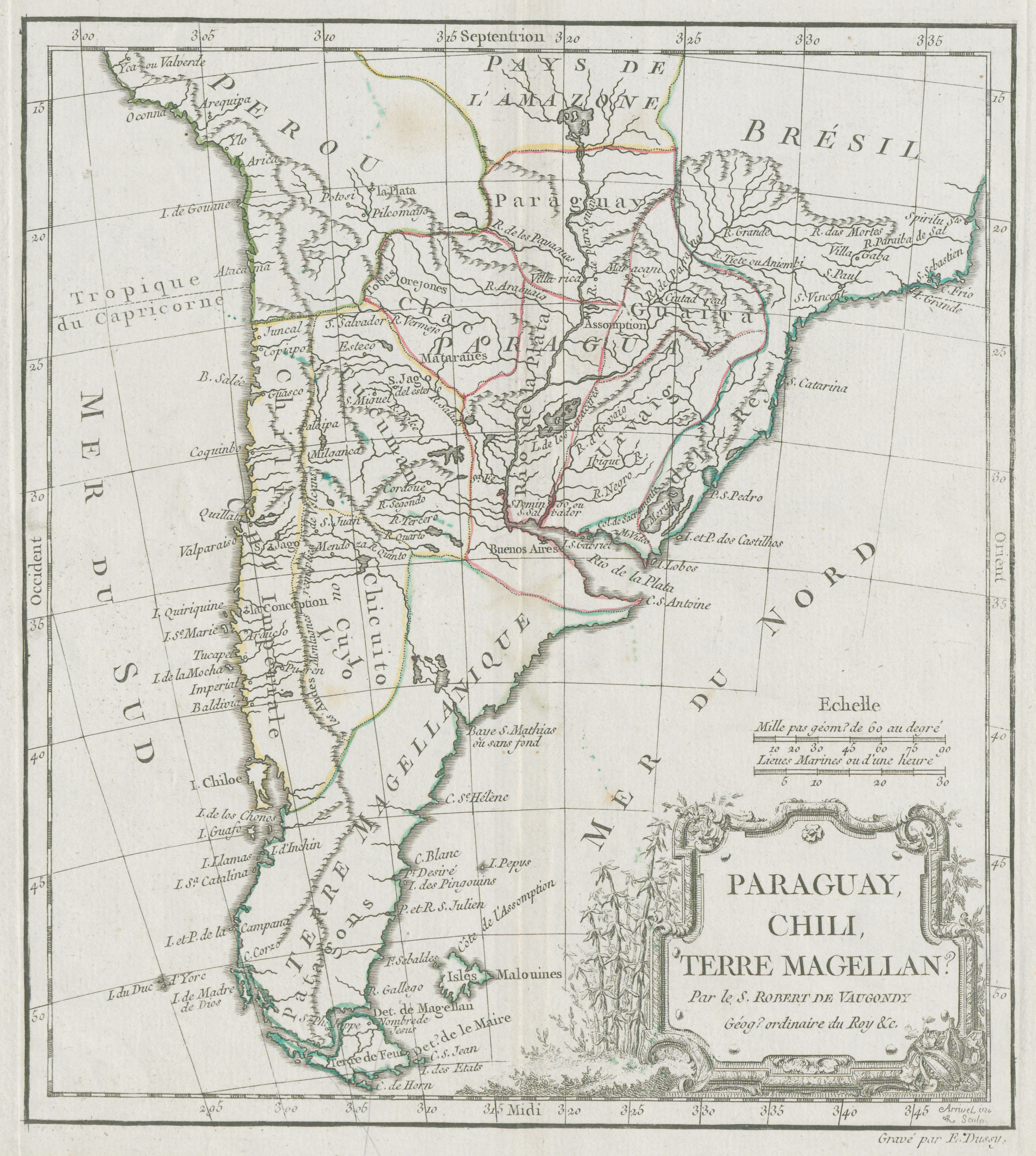
Dispossesions in the Americas

Dispossesions in the Americas

  • Inicio
  • Explorar
  • Autores
  • Sobre
  • Arte
  • Cuerpos
  • Planes de Estudio
  • Herencia Cultural
  • Mapas
  • Territorios
Volver a Explorar

Leyendo en Inglés

Mapa 1700 - 1800

Paraguay, Chili, Terre Magellan.

  • DE VAUGONDY;ROBERT

Publicado: 1770

  • Descargar Imágen
  • Descargar Imágen
Mapa 1700 - 1800

Paraguay, Chili, Terre Magellan.

  • DE VAUGONDY;ROBERT

Publicado: 1770

  • Descargar Imágen

Pueblos

  • PATAGONES
  • OREJONES
  • TOBAS
  • MATARAES

Citas

De Vaugondy, Robert. "Paraguay, Chili, Terre Magellan." Map. 1770. Accessed June 30, 2023. https://digital.iai.spk-berlin.de/viewer/image/630121583/1/LOG_0000/.

  • Descargar Imágen

Artículos Relacionados

LOCALIDADES CON 40% Y MAS DE POBLACION INDIGENA Y TIPO DE MUNICIPIOS, MÉXICO, 2000

LOCALIDADES CON 40% Y MAS DE POBLACION INDIGENA Y TIPO DE MUNICIPIOS, MÉXICO, 2000

Mapa 2000
PUEBLO CHUJ

PUEBLO CHUJ

Mapa 2020
PUEBLO K'ICHE

PUEBLO K'ICHE

Mapa 2020
Peru

Peru

Mapa 1671
GUIANA AND VENEZUELA

GUIANA AND VENEZUELA

Mapa 1900 - 1999
Property Ownership in 1900, Verapaz Guatemala

Property Ownership in 1900, Verapaz Guatemala

Mapa 1900
GUANÁ

GUANÁ

Mapa 2015
Carta para la inteligencia del informe sobre fronteras presentado al Excelentísimo Gobierno nacional por el General Don Wenceslao Paunero. Impreso

Carta para la inteligencia del informe sobre fronteras presentado al Excelentísimo Gobierno nacional por el General Don Wenceslao Paunero. Impreso

Mapa 1850 - 1880

Despojos en las Américas

Un Proyecto de

University of Pennsylvania

Copyright 2024

Con el apoyo de

Mellon Foundation

Diseño y Desarrollo del Sitio

Element 84

Créditos Artísticos

De Vaugondy, Robert. “Paraguay, Chili, Terre Magellan.” Map. 1770. Accessed June 30, 2023. https://digital.iai.spk-berlin.de/viewer/image/630121583/1/LOG_0000/.

Páginas del Sitio

  • Inicio
  • Explorar
  • Autores
  • Sobre
  • Arte
  • Cuerpos
  • Planes de Estudio
  • Herencia Cultural
  • Mapas
  • Territorios