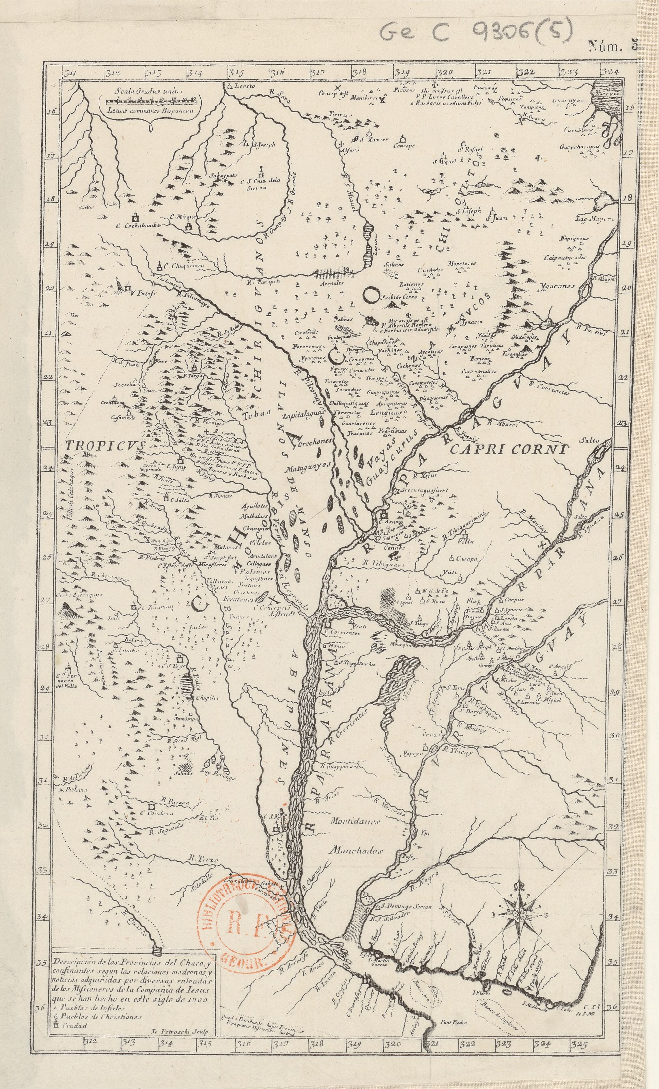
Dispossesions in the Americas

Dispossesions in the Americas

  • Inicio
  • Explorar
  • Autores
  • Sobre
  • Arte
  • Cuerpos
  • Planes de Estudio
  • Herencia Cultural
  • Mapas
  • Territorios
Volver a Explorar

Leyendo en Inglés

Mapa 1656

TERRE FERME ou sont les governations ou gouvernemens de Terre ferme;Cartagene Ste. Marthe;Rio de la Hache;Venezuela;nouvelle Andalusie Popayein;nouveau royme de Grenade;&c

  • SANSON;NICOLAS

Publicado: 1656

  • Descargar Imágen
  • Descargar Imágen
Mapa 1656

TERRE FERME ou sont les governations ou gouvernemens de Terre ferme;Cartagene Ste. Marthe;Rio de la Hache;Venezuela;nouvelle Andalusie Popayein;nouveau royme de Grenade;&c

  • SANSON;NICOLAS

Publicado: 1656

  • Descargar Imágen

Pueblos

  • INDIO DE PERITO
  • WIKIRI
  • AFFAWAYI
  • CANIBALES
  • SAYMA
  • ARORAS
  • CUACHARUCO
  • IWAREPICE
  • CASSIPAGOTAE
  • CARIBES
  • CANURIA
  • AWARAWAQUERI
  • EWAIPANOMA
  • AROWAGOTOS
  • EPARAGOTOS
  • VRRABA
  • CARUPATATES
  • TUMAMANES
  • CHAGUAS
  • TOCUYOS
  • KUIVA
  • COROMOCHOS
  • POCABUYES

Citas

Sanson, Nicolas. Terre ferme ou sont les governations ou gouvernemens de Terre ferme, Cartagene Ste. Marthe, Rio de la Hache, Venezuela, nouvelle Andalusie Popayein, nouveau royme de Grenade, &c. Map. Paris: Chez Pierre Mariette, 1656. Accessed August 28, 2022. https://www.raremaps.com/gallery/detail/65995/terre-ferme-ou-sont-les-governations-ou-gouvernemens-de-ter-sanson.

  • Descargar Imágen

Artículos Relacionados

PROVINCIA DE MATTO GROSSO

PROVINCIA DE MATTO GROSSO

Mapa 1800 - 1850
Plan topográfico de las Provincias de Chocó, Antioquia y Popayán

Plan topográfico de las Provincias de Chocó, Antioquia y Popayán

Mapa 1700
Government map of Nicaragua : from the latest surveys ordered by President Patricio Rivas and Genl. William Walker ;executed under the supervision of the Señor Fermín Ferrer;Governor of the Western Department;1856

Government map of Nicaragua : from the latest surveys ordered by President Patricio Rivas and Genl. William Walker ;executed under the supervision of the Señor Fermín Ferrer;Governor of the Western Department;1856

Mapa 1800 - 1856
EL TERRITORIO AYOREO EN EL MAPA DE PARAGUAY HOY

EL TERRITORIO AYOREO EN EL MAPA DE PARAGUAY HOY

Mapa 2010
VICEROYALTY OF NEW GRANADA AND GOVERNMENT OF CARACAS

VICEROYALTY OF NEW GRANADA AND GOVERNMENT OF CARACAS

Mapa 1813
Ramas de los Idiomas Mayas

Ramas de los Idiomas Mayas

Mapa 1970
Map 2.3 The multilingual context of French Guiana (from Renault-Lescure and Goury 2009: 10)

Map 2.3 The multilingual context of French Guiana (from Renault-Lescure and Goury 2009: 10)

Mapa 2012
"Territorio Indígena Altos de San Antonio (Ngöbes)"

"Territorio Indígena Altos de San Antonio (Ngöbes)"

Mapa 2010

Despojos en las Américas

Un Proyecto de

University of Pennsylvania

Copyright 2024

Con el apoyo de

Mellon Foundation

Diseño y Desarrollo del Sitio

Element 84

Créditos Artísticos

Sanson, Nicolas. Terre ferme ou sont les governations ou gouvernemens de Terre ferme, Cartagene Ste. Marthe, Rio de la Hache, Venezuela, nouvelle Andalusie Popayein, nouveau royme de Grenade, &c. Map. Paris: Chez Pierre Mariette, 1656. Accessed August 28, 2022. https://www.raremaps.com/gallery/detail/65995/terre-ferme-ou-sont-les-governations-ou-gouvernemens-de-ter-sanson.

Páginas del Sitio

  • Inicio
  • Explorar
  • Autores
  • Sobre
  • Arte
  • Cuerpos
  • Planes de Estudio
  • Herencia Cultural
  • Mapas
  • Territorios