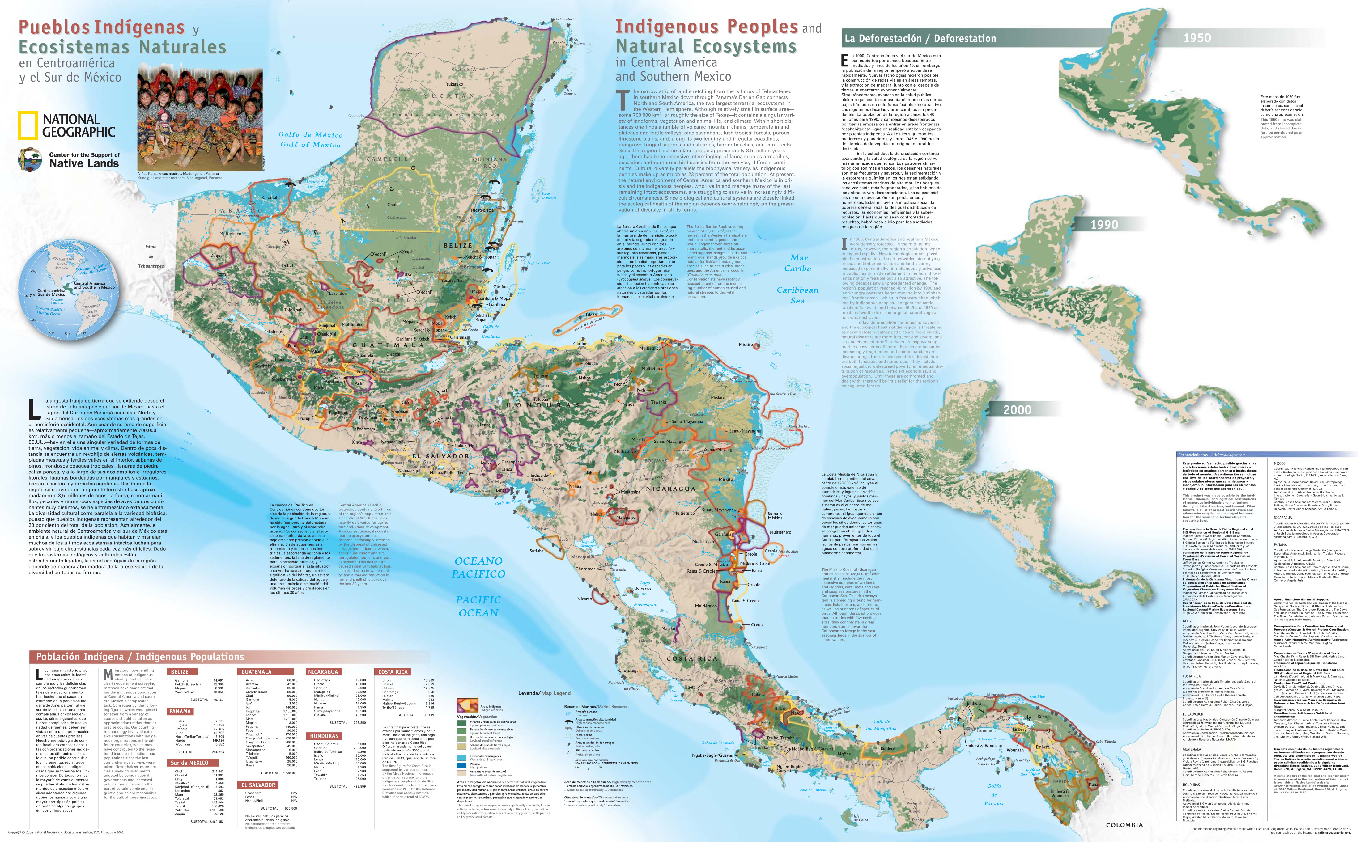
Dispossesions in the Americas

Dispossesions in the Americas

  • Inicio
  • Explorar
  • Autores
  • Sobre
  • Arte
  • Cuerpos
  • Planes de Estudio
  • Herencia Cultural
  • Mapas
  • Territorios
Volver a Explorar

Leyendo en Inglés

Mapa 2000 - 2024

Pueblos Indígenas y Ecosistemas Naturales en Centroamérica y el Sur de México

  • NATIONAL GEOGRAPHIC SOCIETY

Publicado: 2002

  • Descargar Imágen
  • Descargar Imágen
Mapa 2000 - 2024

Pueblos Indígenas y Ecosistemas Naturales en Centroamérica y el Sur de México

  • NATIONAL GEOGRAPHIC SOCIETY

Publicado: 2002

  • Descargar Imágen

Pueblos

  • QEQCHI
  • ITZA
  • MOPAN
  • CHORTI
  • POQOMAM
  • XINCA
  • KAQCHIQUEL
  • TZUTUJIL
  • SIPAKAPENSE
  • MAM
  • TEKTITEKO
  • KICHE
  • ACHI
  • AWAKATECO
  • SAKAPULTEKO
  • POQOMCHI
  • POPTI
  • AKATEKO
  • IXIL
  • QANJOBAL
  • USPANTEKO
  • CHUJ
  • GARIFUNA

Cita

National Geographic Society. "Pueblos Indígenas y Ecosistemas Naturales en Centroamérica y el Sur de México" [Indigenous Peoples and Natural Ecosystems in Central America and the South of Mexico]. ENVIRONMENTAL LAW INSTITUTE. Last modified June 2002. Accessed August 22, 2021. https://www.eli.org/sites/default/files/eli-pubs/3801.pdf.

  • Descargar Imágen

Leyendo en Portugués

Mapa 2000 - 2024

Pueblos Indígenas y Ecosistemas Naturales en Centroamérica y el Sur de México

  • NATIONAL GEOGRAPHIC SOCIETY

Publicado: 2002

  • Descargar Imágen

Pueblos

  • QEQCHI
  • ITZA
  • MOPAN
  • CHORTI
  • POQOMAM
  • XINCA
  • KAQCHIQUEL
  • TZUTUJIL
  • SIPAKAPENSE
  • MAM
  • TEKTITEKO
  • KICHE
  • ACHI
  • AWAKATECO
  • SAKAPULTEKO
  • POQOMCHI
  • POPTI
  • AKATEKO
  • IXIL
  • QANJOBAL
  • USPANTEKO
  • CHUJ
  • GARIFUNA

Cita

National Geographic Society. "Pueblos Indígenas y Ecosistemas Naturales en Centroamérica y el Sur de México" [Indigenous Peoples and Natural Ecosystems in Central America and the South of Mexico]. ENVIRONMENTAL LAW INSTITUTE. Last modified June 2002. Accessed August 22, 2021. https://www.eli.org/sites/default/files/eli-pubs/3801.pdf.

  • Descargar Imágen

Artículos Relacionados

Mapa de la Republica de Guatemala

Mapa de la Republica de Guatemala

Mapa 1800
The Bosawa Reserve and Indigenous Territories;Nicaragua.

The Bosawa Reserve and Indigenous Territories;Nicaragua.

Mapa 2000 - 2003
NLLE. GRENADE CARACAS ET GUYANES.

NLLE. GRENADE CARACAS ET GUYANES.

Mapa 1812
Outside Threats to Maya Lands

Outside Threats to Maya Lands

Mapa 1997
‘INDIAN ROYAL TOWNS’ (REDUCCIONES) IN THE PACAJES PROVINCE (CORREGIMIENTO) UNDER SPANISH COLONIAL RULE IN THE LATE 16TH CENTURY

‘INDIAN ROYAL TOWNS’ (REDUCCIONES) IN THE PACAJES PROVINCE (CORREGIMIENTO) UNDER SPANISH COLONIAL RULE IN THE LATE 16TH CENTURY

Mapa 1570 - 1630
REGIÓN HUASTECA

REGIÓN HUASTECA

Mapa 2000
Northern Mexico and a Portion of Texas 1600-1750 Showing the approximate Locations of Indian tribes

Northern Mexico and a Portion of Texas 1600-1750 Showing the approximate Locations of Indian tribes

Mapa 1600 - 1750
Plate 8. The 18 tribes reported by the Berbice Arawak

Plate 8. The 18 tribes reported by the Berbice Arawak

Mapa 1700 - 1799

Despojos en las Américas

Un Proyecto de

University of Pennsylvania

Copyright 2024

Con el apoyo de

Mellon Foundation

Diseño y Desarrollo del Sitio

Element 84

Créditos Artísticos

National Geographic Society. “Pueblos Indígenas y Ecosistemas Naturales en Centroamérica y el Sur de México” [Indigenous Peoples and Natural Ecosystems in Central America and the South of Mexico]. ENVIRONMENTAL LAW INSTITUTE. Last modified June 2002. Accessed August 22, 2021. https://www.eli.org/sites/default/files/eli-pubs/3801.pdf.

Páginas del Sitio

  • Inicio
  • Explorar
  • Autores
  • Sobre
  • Arte
  • Cuerpos
  • Planes de Estudio
  • Herencia Cultural
  • Mapas
  • Territorios