Dispossesions in the Americas

Dispossesions in the Americas

  • Inicio
  • Explorar
  • Autores
  • Sobre
  • Arte
  • Cuerpos
  • Planes de Estudio
  • Herencia Cultural
  • Mapas
  • Territorios
Volver a Explorar

Leyendo en Inglés

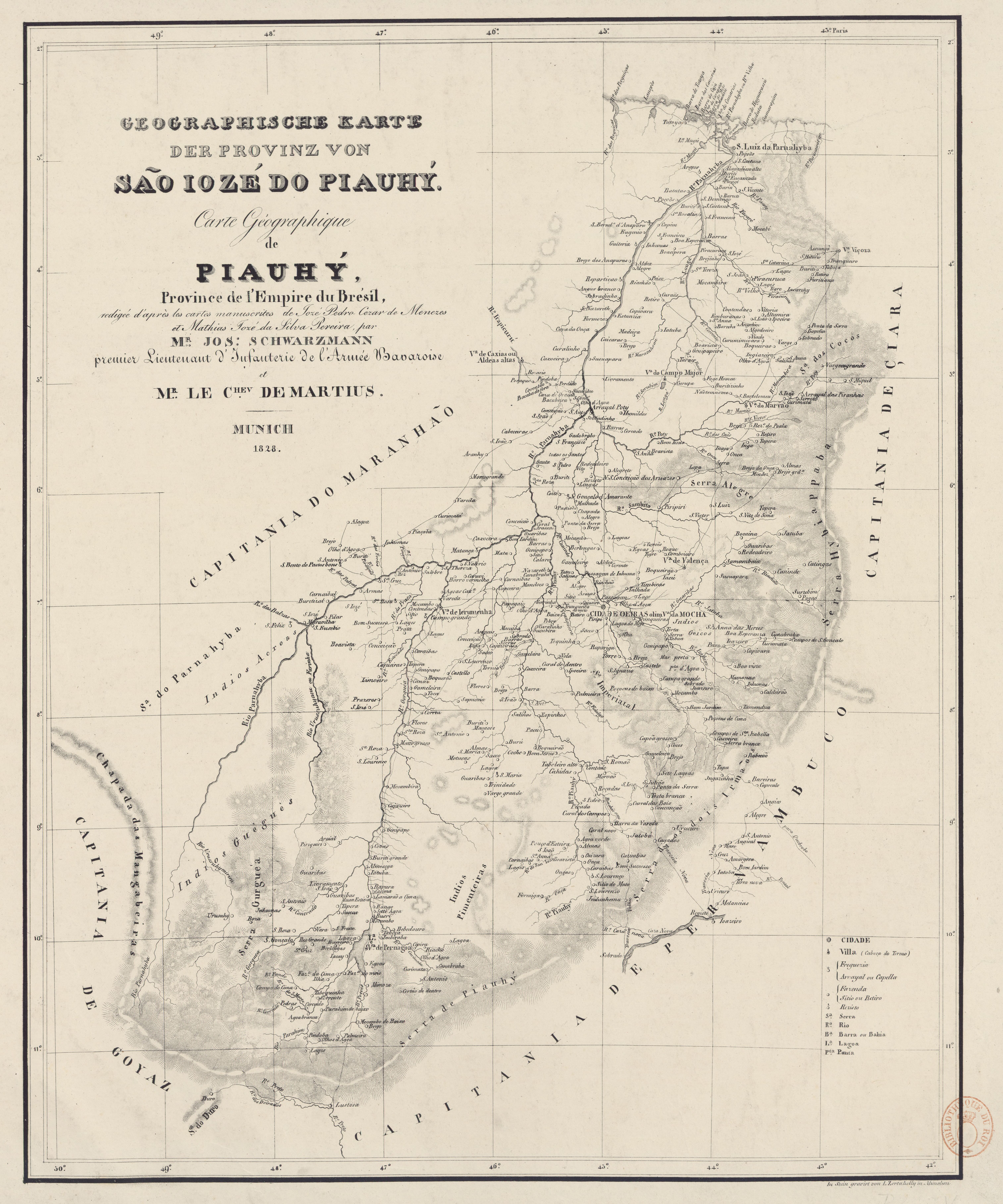
Mapa 1828

GEOGRAPHISCHE KARTE DER PROVINZ VON SÃO JOZÉ DO PIAUHY. Carte Géographique de PIAUHY, Province de l'Empire du Brésil

  • SCHWARZMANN, JOSEPH, ET AL.

Publicado: 1828

  • Descargar Imágen
  • Descargar Imágen
Mapa 1828

GEOGRAPHISCHE KARTE DER PROVINZ VON SÃO JOZÉ DO PIAUHY. Carte Géographique de PIAUHY, Province de l'Empire du Brésil

  • SCHWARZMANN, JOSEPH, ET AL.

Publicado: 1828

  • Descargar Imágen

Pueblos

  • ACROAS
  • GUEGUES
  • PIMENTEIRAS

Citas

Schwarzmann, Joseph, and Carl Friedrich Philipp von Martius. Geographische Karte der Provinz von São Jozé do Piauhy. Carte géographique de Piauhy, province de l'empire du Brésil. Map. Munich, 1828. Accessed August 2, 2023. https://gallica.bnf.fr/ark:/12148/btv1b8490734r/f1.item.
  • Descargar Imágen

Artículos Relacionados

LOS GRUPOS LOCALES AYOREO DENTRO DE SU TERRITORIO

LOS GRUPOS LOCALES AYOREO DENTRO DE SU TERRITORIO

Mapa 1490
South America from the latest discoveries, shewing the Spanish & Portuguese settlements according to Mr. D'Anville

South America from the latest discoveries, shewing the Spanish & Portuguese settlements according to Mr. D'Anville

Mapa 1771
A Sequel of the Seat of War in the West Indies containing… Sub-map title: A large & accurate MAP of part of the Isthmus of Panama, taken from a Spanish drought exhibiting the Country adjacent to that City and Puerto Bello, with the Roads and Course of the River CHAGRE, by which the Treasure of the South Sea is conveyed a cross the Isthmus

A Sequel of the Seat of War in the West Indies containing… Sub-map title: A large & accurate MAP of part of the Isthmus of Panama, taken from a Spanish drought exhibiting the Country adjacent to that City and Puerto Bello, with the Roads and Course of the River CHAGRE, by which the Treasure of the South Sea is conveyed a cross the Isthmus

Mapa 1740
Croquis de carte du Nicaragua aux XVe et XVIe siécles/ par Désiré Pector.

Croquis de carte du Nicaragua aux XVe et XVIe siécles/ par Désiré Pector.

Mapa 1880 - 1888
TERRITORIO DEL PUEBLO SHUAR ATRUAM

TERRITORIO DEL PUEBLO SHUAR ATRUAM

Mapa 2017
San Pedro Columbia

San Pedro Columbia

Mapa 1997
Grupos étnicos en la época del caucho (1911-1924)

Grupos étnicos en la época del caucho (1911-1924)

Mapa 1911 - 1924
Carte hist.;Prov. des Missions;etabl. Jesuites;Parana et l'Uruguay;1575- 1768

Carte hist.;Prov. des Missions;etabl. Jesuites;Parana et l'Uruguay;1575- 1768

Mapa 1575 - 1768

Despojos en las Américas

Un Proyecto de

University of Pennsylvania

Copyright 2024

Con el apoyo de

Mellon Foundation

Diseño y Desarrollo del Sitio

Element 84

Créditos Artísticos

Schwarzmann, Joseph, and Carl Friedrich Philipp von Martius. Geographische Karte der Provinz von São Jozé do Piauhy. Carte géographique de Piauhy, province de l’empire du Brésil. Map. Munich, 1828. Accessed August 2, 2023. https://gallica.bnf.fr/ark:/12148/btv1b8490734r/f1.item.
Páginas del Sitio

  • Inicio
  • Explorar
  • Autores
  • Sobre
  • Arte
  • Cuerpos
  • Planes de Estudio
  • Herencia Cultural
  • Mapas
  • Territorios