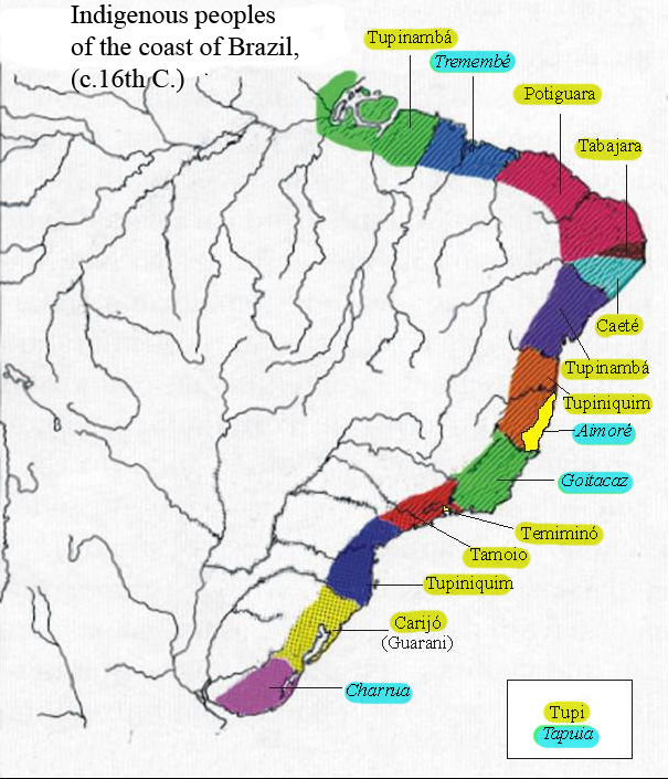
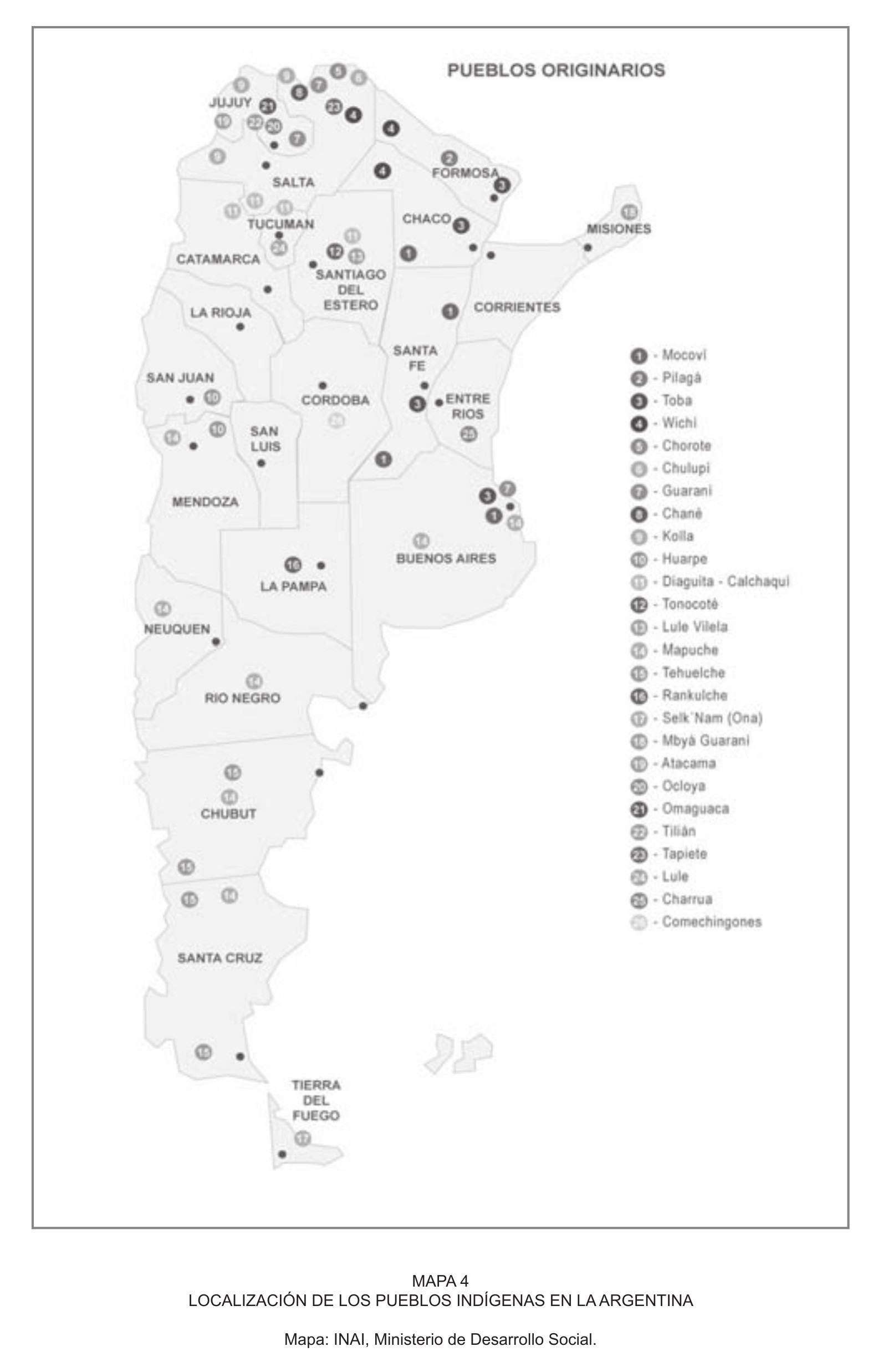
Dispossesions in the Americas

Dispossesions in the Americas

  • Inicio
  • Explorar
  • Autores
  • Sobre
  • Arte
  • Cuerpos
  • Planes de Estudio
  • Herencia Cultural
  • Mapas
  • Territorios
Volver a Explorar

Leyendo en Inglés

Mapa 1500 - 1599

Indigenous peoples of the coast of Brazil, (c. 16th C.)

    Publicado: 2011

    • Descargar Imágen
    • Descargar Imágen
    Mapa 1500 - 1599

    Indigenous peoples of the coast of Brazil, (c. 16th C.)

      Publicado: 2011

      • Descargar Imágen

      Pueblos

      • TUPINAMBA
      • TREMEMBE
      • POTIGUARA
      • TABAJARA
      • CAETE
      • TUPINIQUIM
      • AIMORE
      • GOITACAZ
      • TEMIMINO
      • TAMOIO
      • CARIJO
      • GUARANI
      • CHARRUA
      • TUPI
      • TAPUIA

      Cita

      "Indigenous peoples of the coast of Brazil, (c. 16th C.)." Map. Wikimedia Commons. June 26, 2011. https://commons.wikimedia.org/wiki/File:Map_of_indigenous_peoples_of_Brazil_(16th_C.).jpg.

      • Descargar Imágen

      Leyendo en Portugués

      Mapa 1500 - 1599

      Indigenous peoples of the coast of Brazil, (c. 16th C.)

        Publicado: 2011

        • Descargar Imágen

        Pueblos

        • TUPINAMBA
        • TREMEMBE
        • POTIGUARA
        • TABAJARA
        • CAETE
        • TUPINIQUIM
        • AIMORE
        • GOITACAZ
        • TEMIMINO
        • TAMOIO
        • CARIJO
        • GUARANI
        • CHARRUA
        • TUPI
        • TAPUIA

        Cita

        "Indigenous peoples of the coast of Brazil, (c. 16th C.)." Map. Wikimedia Commons. June 26, 2011. https://commons.wikimedia.org/wiki/File:Map_of_indigenous_peoples_of_Brazil_(16th_C.).jpg.

        • Descargar Imágen

        Artículos Relacionados

        Carte particulière de l'Isle et des environs de Cayenne colonie françoise À Paris Chez Desnos, Ingénieur pour les Globes et Sphères.

        Carte particulière de l'Isle et des environs de Cayenne colonie françoise À Paris Chez Desnos, Ingénieur pour les Globes et Sphères.

        Mapa 1700 - 1799
        Mapa del Río de la Plata y de sus afluentes

        Mapa del Río de la Plata y de sus afluentes

        Mapa 1600 - 1699
        LOS CACICAZGOS MUISCAS ALRDEDOR DE 1470

        LOS CACICAZGOS MUISCAS ALRDEDOR DE 1470

        Mapa 1470
        LOCALIZACIÓN DE LOS PUEBLOS INDÍGENAS EN LA ARGENTINA

        LOCALIZACIÓN DE LOS PUEBLOS INDÍGENAS EN LA ARGENTINA

        Mapa 2004
        Primary Maroon communities in Jamaica

        Primary Maroon communities in Jamaica

        Mapa 2015
        [Carte manuscrite de l'Isthme et la Baye de Panama et contrées adjacentes]

        [Carte manuscrite de l'Isthme et la Baye de Panama et contrées adjacentes]

        Mapa 1730 - 1760
        TAJO

        TAJO

        Obra de Arte
        Part of the Southwest 1600-1750 Showing Locations of "Unknown Athapaskans"

        Part of the Southwest 1600-1750 Showing Locations of "Unknown Athapaskans"

        Mapa 1600 - 1750

        Despojos en las Américas

        Un Proyecto de

        University of Pennsylvania

        Copyright 2024

        Con el apoyo de

        Mellon Foundation

        Diseño y Desarrollo del Sitio

        Element 84

        Créditos Artísticos

        “Indigenous peoples of the coast of Brazil, (c. 16th C.).” Map. Wikimedia Commons. June 26, 2011. https://commons.wikimedia.org/wiki/File:Map_of_indigenous_peoples_of_Brazil_(16th_C.).jpg.

        Páginas del Sitio

        • Inicio
        • Explorar
        • Autores
        • Sobre
        • Arte
        • Cuerpos
        • Planes de Estudio
        • Herencia Cultural
        • Mapas
        • Territorios