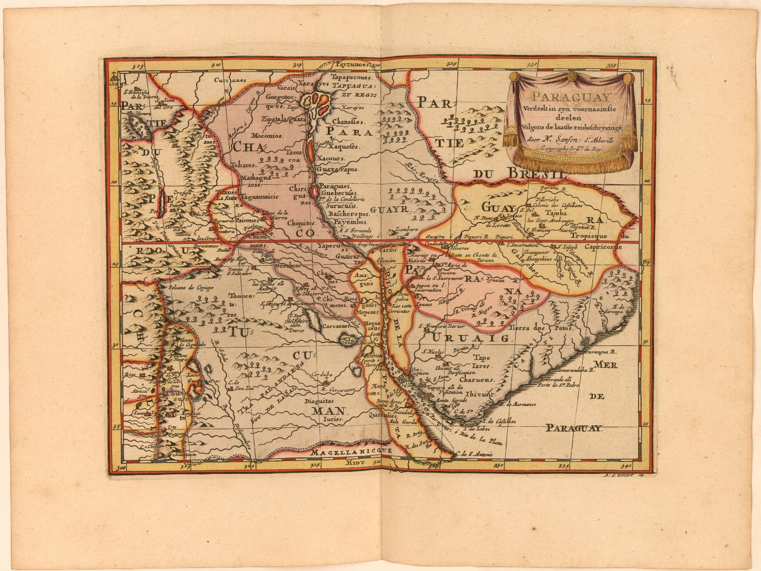
Dispossesions in the Americas

Dispossesions in the Americas

  • Inicio
  • Explorar
  • Autores
  • Sobre
  • Arte
  • Cuerpos
  • Planes de Estudio
  • Herencia Cultural
  • Mapas
  • Territorios
Volver a Explorar

Leyendo en Inglés

Mapa 1600 - 1667

Paraguay Verdeelt in zyn voornaamste deelen Volgens de laatste reisbeschryvinge door N. Sanson d.'Abbeville, Geographe ordre. du Ro

  • La Croix, Phérotée de

Publicado: 1705

  • Descargar Imágen
  • Descargar Imágen
Mapa 1600 - 1667

Paraguay Verdeelt in zyn voornaamste deelen Volgens de laatste reisbeschryvinge door N. Sanson d.'Abbeville, Geographe ordre. du Ro

  • La Croix, Phérotée de

Publicado: 1705

  • Descargar Imágen

Pueblos

  • DIAGUITAS
  • GUAYCURU
  • CHIRIGUANOS

Cita

La Croix, Phérotée de. "Paraguay Verdeelt in zyn voornaamste deelen Volgens de laatste reisbeschryvinge door N. Sanson d.'Abbeville, Geographe ordre. du Roy." Map. 1705. Accessed March 10, 2022. https://jcb.lunaimaging.com/luna/servlet/detail/JCBMAPS~1~1~6401~115902583:Paraguay-Verdeelt-in-zyn-voornaamst?sort=normalized_date%2Cfile_name%2Csource_author%2Csource_title#

  • Descargar Imágen

Leyendo en Portugués

Mapa 1600 - 1667

Paraguay Verdeelt in zyn voornaamste deelen Volgens de laatste reisbeschryvinge door N. Sanson d.'Abbeville, Geographe ordre. du Ro

  • La Croix, Phérotée de

Publicado: 1705

  • Descargar Imágen

Pueblos

  • DIAGUITAS
  • GUAYCURU
  • CHIRIGUANOS

Cita

La Croix, Phérotée de. "Paraguay Verdeelt in zyn voornaamste deelen Volgens de laatste reisbeschryvinge door N. Sanson d.'Abbeville, Geographe ordre. du Roy." Map. 1705. Accessed March 10, 2022. https://jcb.lunaimaging.com/luna/servlet/detail/JCBMAPS~1~1~6401~115902583:Paraguay-Verdeelt-in-zyn-voornaamst?sort=normalized_date%2Cfile_name%2Csource_author%2Csource_title#

  • Descargar Imágen

Artículos Relacionados

The Bosawa Reserve and Indigenous Territories;Nicaragua.

The Bosawa Reserve and Indigenous Territories;Nicaragua.

Mapa 2000 - 2003
A Map of part of Yucatan or of that Part of the Eastern Shore Within the Bay of Honduras Alloted to Great Britain for the Cutting of Logwood, in consequence of the Convention Signed with Spain on the 14th July 1786.

A Map of part of Yucatan or of that Part of the Eastern Shore Within the Bay of Honduras Alloted to Great Britain for the Cutting of Logwood, in consequence of the Convention Signed with Spain on the 14th July 1786.

Mapa 1700
Ilustración 2. Territorios de Pueblos y Nacionalidades en la Sierra Ecuador;2006

Ilustración 2. Territorios de Pueblos y Nacionalidades en la Sierra Ecuador;2006

Mapa 2006
GEOGRAPHISCHE KARTE DER PROVINZ VON SÃO JOZÉ DO PIAUHY. Carte Géographique de PIAUHY, Province de l'Empire du Brésil

GEOGRAPHISCHE KARTE DER PROVINZ VON SÃO JOZÉ DO PIAUHY. Carte Géographique de PIAUHY, Province de l'Empire du Brésil

Mapa 1828
ANGAITÉ

ANGAITÉ

Mapa 2015
INTENDENCIA DE ZACATECAS

INTENDENCIA DE ZACATECAS

Mapa 1800
Partie de Terre Ferme ou sont Guiane et Caribane. Augmentée et Corrigée suivant les dernières Relations

Partie de Terre Ferme ou sont Guiane et Caribane. Augmentée et Corrigée suivant les dernières Relations

Mapa 1594 - 1596
PUEBLO TARAHUMARA

PUEBLO TARAHUMARA

Mapa 2020

Despojos en las Américas

Un Proyecto de

University of Pennsylvania

Copyright 2024

Con el apoyo de

Mellon Foundation

Diseño y Desarrollo del Sitio

Element 84

Créditos Artísticos

La Croix, Phérotée de. “Paraguay Verdeelt in zyn voornaamste deelen Volgens de laatste reisbeschryvinge door N. Sanson d.‘Abbeville, Geographe ordre. du Roy.” Map. 1705. Accessed March 10, 2022. https://jcb.lunaimaging.com/luna/servlet/detail/JCBMAPS~1~1~6401~115902583:Paraguay-Verdeelt-in-zyn-voornaamst?sort=normalized_date%2Cfile_name%2Csource_author%2Csource_title#

Páginas del Sitio

  • Inicio
  • Explorar
  • Autores
  • Sobre
  • Arte
  • Cuerpos
  • Planes de Estudio
  • Herencia Cultural
  • Mapas
  • Territorios