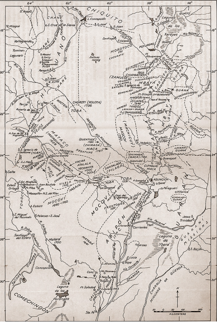
Dispossesions in the Americas

Dispossesions in the Americas

  • Inicio
  • Explorar
  • Autores
  • Sobre
  • Arte
  • Cuerpos
  • Planes de Estudio
  • Herencia Cultural
  • Mapas
  • Territorios
Volver a Explorar

Leyendo en Inglés

Mapa 1527 - 1790

Tribus del Gran Chaco

  • Haynes, Steward Julian

Publicado: 1946

  • Descargar Imágen
  • Descargar Imágen
Mapa 1527 - 1790

Tribus del Gran Chaco

  • Haynes, Steward Julian

Publicado: 1946

  • Descargar Imágen

Pueblos

  • CHOROTI
  • TOBA
  • CHANE
  • PAYAGUA
  • CADUVEO
  • GUAICURU
  • GUANA
  • MBAYA
  • MATACO
  • GUATO
  • CHAMACOCO
  • GUACHI
  • VILELA
  • PILAGA
  • MOCOVI
  • ABIPON
  • GUARANI
  • TONOCOTE
  • CHARRUA
  • CALCHAQUI
  • DIAGUITA
  • COMECHINGON
  • LULE
  • CHIRIGUANO

Cita

Steward Julian Haynes, Editor. Handbook of South American Indians. Washington, U.S. G.P.O. https://pueblosoriginarios.com/recursos/mapas/gran_chaco/tribus.html

  • Descargar Imágen

Leyendo en Portugués

Mapa 1527 - 1790

Tribus del Gran Chaco

  • Haynes, Steward Julian

Publicado: 1946

  • Descargar Imágen

Pueblos

  • CHOROTI
  • TOBA
  • CHANE
  • PAYAGUA
  • CADUVEO
  • GUAICURU
  • GUANA
  • MBAYA
  • MATACO
  • GUATO
  • CHAMACOCO
  • GUACHI
  • VILELA
  • PILAGA
  • MOCOVI
  • ABIPON
  • GUARANI
  • TONOCOTE
  • CHARRUA
  • CALCHAQUI
  • DIAGUITA
  • COMECHINGON
  • LULE
  • CHIRIGUANO

Cita

Steward Julian Haynes, Editor. Handbook of South American Indians. Washington, U.S. G.P.O. https://pueblosoriginarios.com/recursos/mapas/gran_chaco/tribus.html

  • Descargar Imágen

Artículos Relacionados

Colombia Prima or South America drawn from the large map in eight sheets by Louis Stanislas D'Arcy Delarochette

Colombia Prima or South America drawn from the large map in eight sheets by Louis Stanislas D'Arcy Delarochette

Mapa 1811
CARTE DE LA COSTE DEPUIS LA RIVIERE DES AMAZONES JUSQUES A L'ISLE DE CAYENNE

CARTE DE LA COSTE DEPUIS LA RIVIERE DES AMAZONES JUSQUES A L'ISLE DE CAYENNE

Mapa 1701
CÓDICE VINDOBONENSIS MEXICANUS 1, P.3

CÓDICE VINDOBONENSIS MEXICANUS 1, P.3

Mapa 1500 - 1599
Veta Negra

Veta Negra

Obra de Arte
La sirena del Ucayali

La sirena del Ucayali

Obra de Arte
Mosquitia or The Mosquito Shore with The Eastern Part of Yucatán as far as the 20th Degree of North Latitude

Mosquitia or The Mosquito Shore with The Eastern Part of Yucatán as far as the 20th Degree of North Latitude

Mapa 1787
Mapa de Idiomas Nacionales, República de Guatemala B'o'oylu'um Xokt'an ti a' Nojlu'umil ti Paxi (Itza')

Mapa de Idiomas Nacionales, República de Guatemala B'o'oylu'um Xokt'an ti a' Nojlu'umil ti Paxi (Itza')

Mapa 2016
Provinces depéndant de la triple alliance

Provinces depéndant de la triple alliance

Mapa

Despojos en las Américas

Un Proyecto de

University of Pennsylvania

Copyright 2024

Con el apoyo de

Mellon Foundation

Diseño y Desarrollo del Sitio

Element 84

Créditos Artísticos

Steward Julian Haynes, Editor. Handbook of South American Indians. Washington, U.S. G.P.O. https://pueblosoriginarios.com/recursos/mapas/gran_chaco/tribus.html

Páginas del Sitio

  • Inicio
  • Explorar
  • Autores
  • Sobre
  • Arte
  • Cuerpos
  • Planes de Estudio
  • Herencia Cultural
  • Mapas
  • Territorios