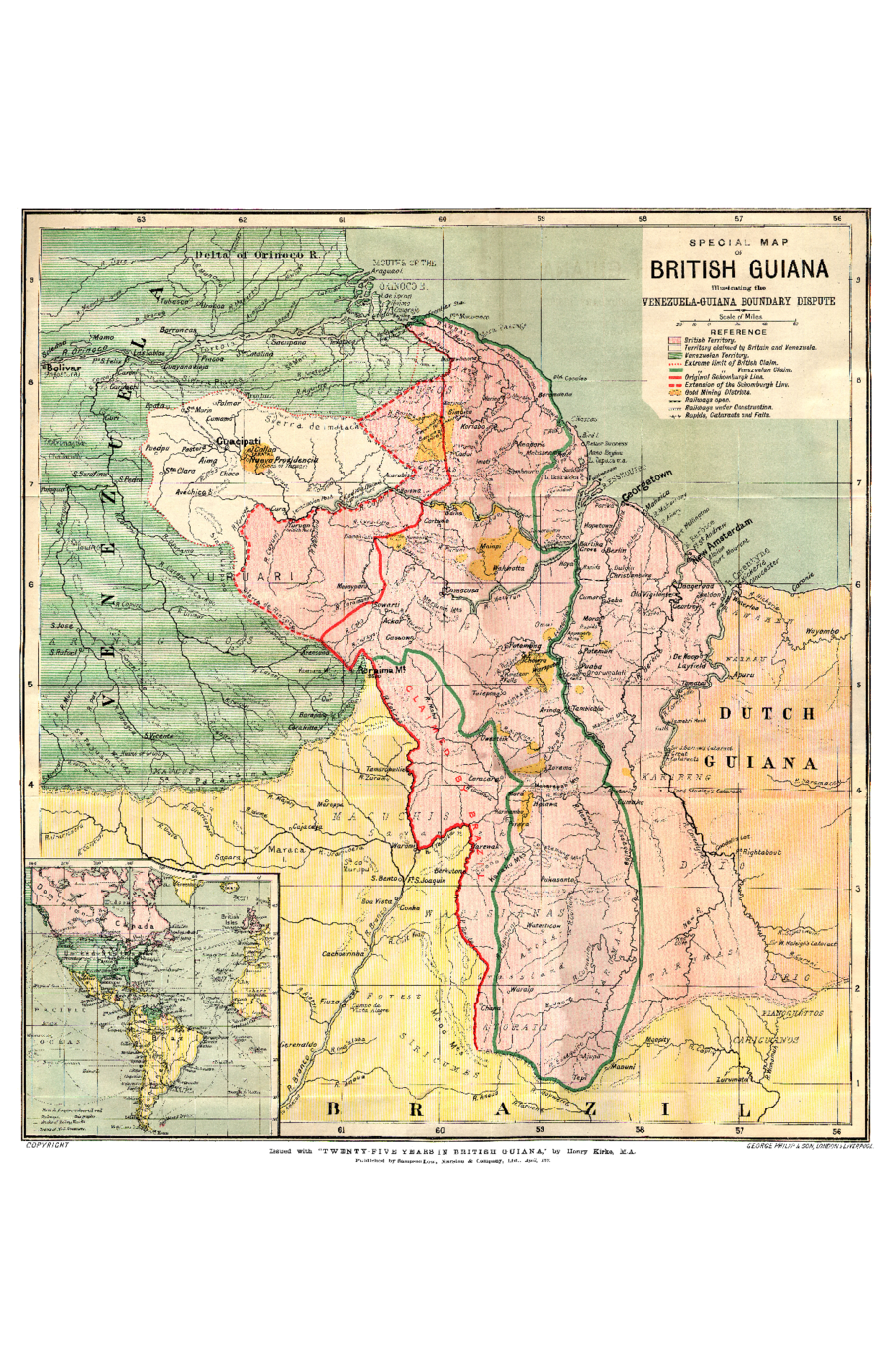
Dispossesions in the Americas

Dispossesions in the Americas

  • Home
  • Explore
  • About
  • Authors
  • Art
  • Bodies
  • Curricula
  • Cultural Heritage
  • Maps
  • Territories
Back to Explore
Map 1898

SPECIAL MAP OF BRITISH GUIANA Illustrating the VENEZUELA-GUIANA BOUNDARY DISPUTE

    Published: 1898

    • Download Image

    Peoples

    • ARAWAK
    • GUARUANA
    • GUAICAS
    • WARAO
    • ARNACOTO
    • MAKU
    • WAIKAS
    • MUCUCHIES
    • WAPISHANA
    • ARAWAKEN
    • KARIBENG
    • DRIO
    • ATORAI
    • TARUMAS
    • PIANOGHOTTOS
    • CARIGUANOS
    • SIRICUMES

    Citation

    Special Map of British Guiana Illustrating the Venezuela-Guiana Boundary Dispute. Map. London & Liverpool: George Philip & Son;1898. Accessed March 4;2023. https://www.elibron.com/wp-content/uploads/745/map_1.pdf.

    • Download Image

    Reading in Spanish

    Map 1898

    SPECIAL MAP OF BRITISH GUIANA Illustrating the VENEZUELA-GUIANA BOUNDARY DISPUTE

      Published: 1898

      • Download Image
      • Download Image

      Related Content

      Mobilizações étnicas e transformações sociais no Rio Negro

      Mobilizações étnicas e transformações sociais no Rio Negro

      Map 2007 - 2012
      REPÚBLICA DEL PARAGUAY INSTITUTO PARAGUAYO DEL INDÍGENA (I.N.D.I.) PARCIALIDADES INDÍGENAS ACTUALES

      REPÚBLICA DEL PARAGUAY INSTITUTO PARAGUAYO DEL INDÍGENA (I.N.D.I.) PARCIALIDADES INDÍGENAS ACTUALES

      Map
      THE KARANQAS AYMARA POLITY UNDER SPANISH COLONIAL RULE IN THE 18TH CENTURY

      THE KARANQAS AYMARA POLITY UNDER SPANISH COLONIAL RULE IN THE 18TH CENTURY

      Map 1750 - 1804
      PUEBLO CORA

      PUEBLO CORA

      Map 2020
      ETATS-UNIS DU BRÉSIL: Carte politique

      ETATS-UNIS DU BRÉSIL: Carte politique

      Map 1908
      OAXACA

      OAXACA

      Map 2015
      Mapa de América del Sur con indicación de tierras
     habitadas por extranjeros

      Mapa de América del Sur con indicación de tierras habitadas por extranjeros

      Map 1682
      [Mapa de América del Sur desde el Ecuador hasta el Estrecho de Magallanes.]

      [Mapa de América del Sur desde el Ecuador hasta el Estrecho de Magallanes.]

      Map 1600

      Dispossessions in the Americas

      A project by

      University of Pennsylvania

      Copyright 2024

      With support from

      Mellon Foundation

      Site design & development

      Element 84

      Art Credits

      Special Map of British Guiana Illustrating the Venezuela-Guiana Boundary Dispute. Map. London & Liverpool: George Philip & Son;1898. Accessed March 4;2023. https://www.elibron.com/wp-content/uploads/745/map_1.pdf.

      Site Pages

      • Home
      • Explore
      • About
      • Authors
      • Art
      • Bodies
      • Curricula
      • Cultural Heritage
      • Maps
      • Territories