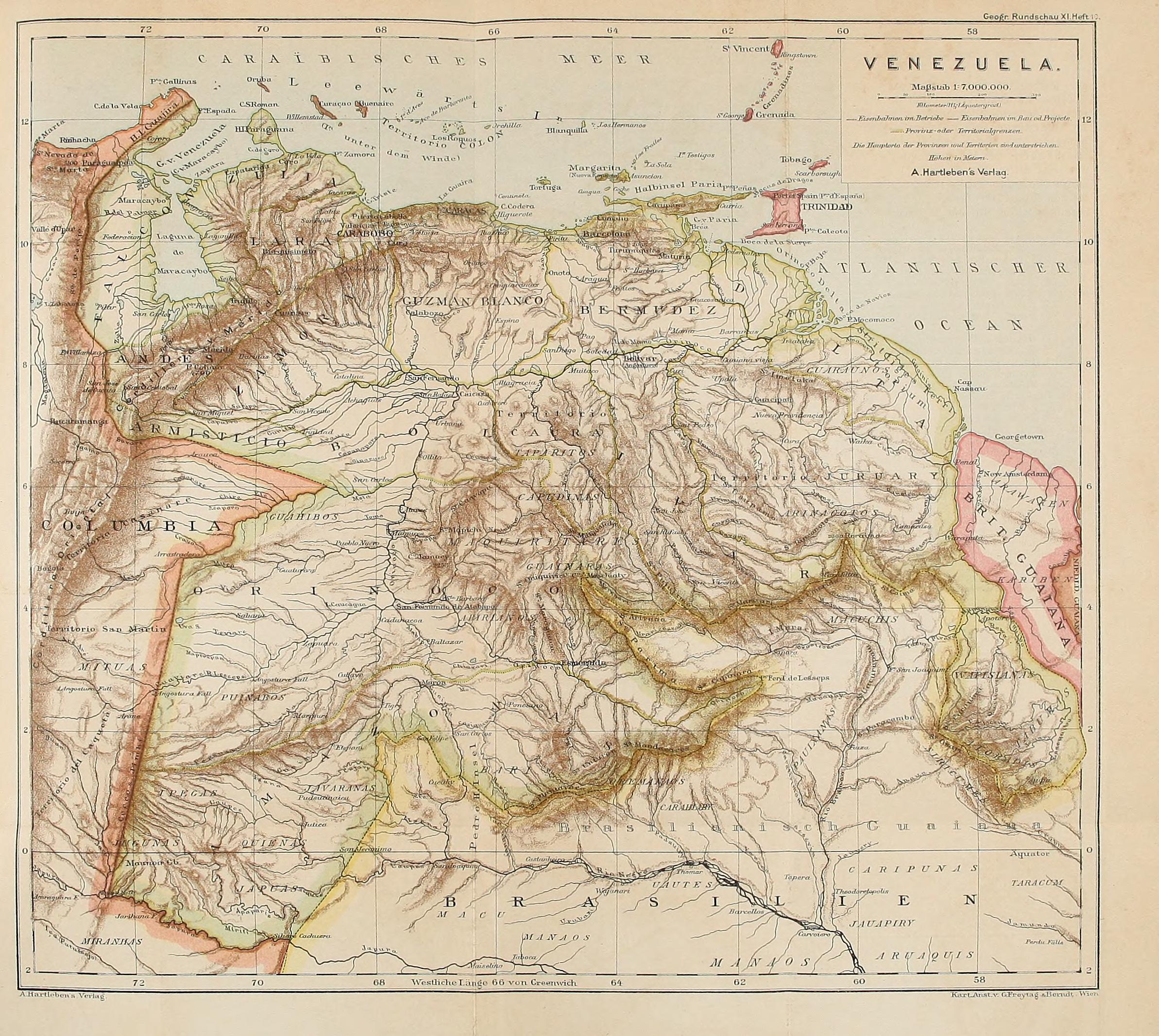
Dispossesions in the Americas

Dispossesions in the Americas

  • Home
  • Explore
  • About
  • Authors
  • Art
  • Bodies
  • Curricula
  • Cultural Heritage
  • Maps
  • Territories
Back to Explore
Map 1878

VENEZUELA

    Published: 1878

    • Download Image

    Peoples

    • GUARUANA
    • TAPARITAS
    • JIVI
    • CADUPINAPOS
    • YEKUANA
    • GUAINARES
    • ARNACOTO
    • ARAWAK
    • CARIBE
    • WAPISHANA
    • MUCUCHIES
    • ABERIANA
    • PUINAVE
    • JAVARANAS
    • BARI
    • MAKU
    • JAPUAS
    • JUGUNAS
    • YPECAS
    • QUIENAS
    • MAJANAO
    • PAUICANAS
    • CARAHIABY
    • OREMANAOS
    • JAUAPIRY
    • MITUAS
    • TABURAS
    • SIRIEUMES
    • ATORADIS
    • TABUMAS
    • TARACUM
    • CARIPUNAS
    • UAUTES
    • MIRANHAS

    Citation

    "Venezuela." Map. In Deutsche Rundschau für Geographie;edited by Friedrich Umlauft;459. Vol. 11. Wien A. Hartleben;1878. Accessed February 11;2023. https://archive.org/details/deutscherundscha11wien/page/458/mode/2up.

    • Download Image

    Reading in Spanish

    Map 1878

    VENEZUELA

      Published: 1878

      • Download Image
      • Download Image

      Related Content

      Amerique Meridionale. Dressee par C.V. Monin. Paris. Armand Aubree;Editeur. Rue Taranne;14. Grave sur Acier par L. Grenier;Rue des Noyers;No. 33. La Letttre gravee par Mardelet. (1837)

      Amerique Meridionale. Dressee par C.V. Monin. Paris. Armand Aubree;Editeur. Rue Taranne;14. Grave sur Acier par L. Grenier;Rue des Noyers;No. 33. La Letttre gravee par Mardelet. (1837)

      Map 1837
      Reproduction of a 4th century mural painted on the wall of a royal residence at La Sufricaya in the Peten region of Guatemala. Mural 6 North.

      Reproduction of a 4th century mural painted on the wall of a royal residence at La Sufricaya in the Peten region of Guatemala. Mural 6 North.

      Map 300 - 400
      Map of Nicaragua showing departmental divisionsand projected routes of interoceanic communication.

      Map of Nicaragua showing departmental divisionsand projected routes of interoceanic communication.

      Map 1851
      "Pueblos Indígenas 1940 y Cacicazgos del Siglo XVI de Costa Rica"

      "Pueblos Indígenas 1940 y Cacicazgos del Siglo XVI de Costa Rica"

      Map 1500 - 1899
      Mapa del Gran Chaco y Provincias Adyacentes.

      Mapa del Gran Chaco y Provincias Adyacentes.

      Map 1885
      Argentina, Paraguay and Uruguay 1648 CE

      Argentina, Paraguay and Uruguay 1648 CE

      Map 1648
      CARTE DU GRAND CHACO (TERRITOIRE INDIEN DU NORD) et DES CONTRÉES VOISINES

      CARTE DU GRAND CHACO (TERRITOIRE INDIEN DU NORD) et DES CONTRÉES VOISINES

      Map 1520
      Brésil et Pays des Amazones, avec le Gouvernement de Buenos-Ayres

      Brésil et Pays des Amazones, avec le Gouvernement de Buenos-Ayres

      Map 1788

      Dispossessions in the Americas

      A project by

      University of Pennsylvania

      Copyright 2024

      With support from

      Mellon Foundation

      Site design & development

      Element 84

      Art Credits

      “Venezuela.” Map. In Deutsche Rundschau für Geographie;edited by Friedrich Umlauft;459. Vol. 11. Wien A. Hartleben;1878. Accessed February 11;2023. https://archive.org/details/deutscherundscha11wien/page/458/mode/2up.

      Site Pages

      • Home
      • Explore
      • About
      • Authors
      • Art
      • Bodies
      • Curricula
      • Cultural Heritage
      • Maps
      • Territories