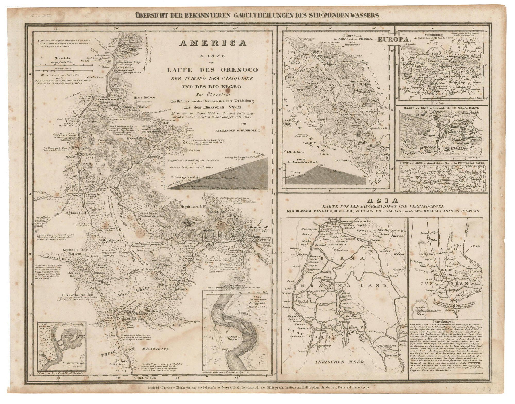
Dispossesions in the Americas

Dispossesions in the Americas

  • Home
  • Explore
  • About
  • Authors
  • Art
  • Bodies
  • Curricula
  • Cultural Heritage
  • Maps
  • Territories
Back to Explore
Map 1850

AMERICA KARATE VON LAUFE DES ORENOCO DES ATABAPO DES CASIQUIARE UND DES RIO NEGRO

  • HUMBOLT;ALEXANDER VON

Published: 1800

  • Download Image

Peoples

  • PIAROA
  • MACOS
  • PUINAVE
  • EQUINABIS
  • MANIVAS
  • CHURUVICHAGENA
  • YAVARANA
  • CURACHICANAS
  • YEKUANA
  • ABERIANA
  • GUAINARES
  • GUAICAS

Citation

Humbolt;Alexander von. America Karate von Laufe des Orenoco des Atabapo de Casiquiare und des Rio Negro. Map. Amsterdam: Instituts zu Hildburghsn;1850. Accessed January 25;2023. https://babel.banrepcultural.org/digital/collection/p17054coll13/id/520/rec/66.

  • Download Image

Reading in Spanish

Map 1850

AMERICA KARATE VON LAUFE DES ORENOCO DES ATABAPO DES CASIQUIARE UND DES RIO NEGRO

  • HUMBOLT;ALEXANDER VON

Published: 1800

  • Download Image
  • Download Image

Related Content

MAPPA CHOROGRAPHICA da Provincia DE STA CATHARINA, PARTE DA PA. DE S. PAULO E DA PA. DE RIO GRANDE DO SUL E PARTE DA REPUBLICA DO PARAGUAY

MAPPA CHOROGRAPHICA da Provincia DE STA CATHARINA, PARTE DA PA. DE S. PAULO E DA PA. DE RIO GRANDE DO SUL E PARTE DA REPUBLICA DO PARAGUAY

Map 1774 - 1842
Modern Distribution and Location of Tzetzal and Tzotzil Communities

Modern Distribution and Location of Tzetzal and Tzotzil Communities

Map 1959
Mapa que muestra la zona al este y al sur del río Paraná, desde los 27°00' S. a 37°00' S. y Uruguay

Mapa que muestra la zona al este y al sur del río Paraná, desde los 27°00' S. a 37°00' S. y Uruguay

Map 1750
KARTE des OBER-ORINOCO;ATABAPO U GUAINÍA

KARTE des OBER-ORINOCO;ATABAPO U GUAINÍA

Map 1909
ANAHUAC Comprenant les Royaumes de Mexico, d'Acolhuacan, de Mechoacan, et les Republiques de Tlascala, de Cholula, de Huexotxinco & Tels qu 'ils etaient das l'annee 1521

ANAHUAC Comprenant les Royaumes de Mexico, d'Acolhuacan, de Mechoacan, et les Republiques de Tlascala, de Cholula, de Huexotxinco & Tels qu 'ils etaient das l'annee 1521

Map 1843
ENLHET Lengua del Norte

ENLHET Lengua del Norte

Map 2015
EL SEÑORÍO  AYMARA DE LOS SURAS: COLONIAS DE SURA BAJO EL DOMINIO INCA EN EL SIGLO XVI

EL SEÑORÍO AYMARA DE LOS SURAS: COLONIAS DE SURA BAJO EL DOMINIO INCA EN EL SIGLO XVI

Map 1500 - 599
Discrepçion y mapa del territorio que ocupan los indios pijaos

Discrepçion y mapa del territorio que ocupan los indios pijaos

Map 1608

Dispossessions in the Americas

A project by

University of Pennsylvania

Copyright 2024

With support from

Mellon Foundation

Site design & development

Element 84

Art Credits

Humbolt;Alexander von. America Karate von Laufe des Orenoco des Atabapo de Casiquiare und des Rio Negro. Map. Amsterdam: Instituts zu Hildburghsn;1850. Accessed January 25;2023. https://babel.banrepcultural.org/digital/collection/p17054coll13/id/520/rec/66.

Site Pages

  • Home
  • Explore
  • About
  • Authors
  • Art
  • Bodies
  • Curricula
  • Cultural Heritage
  • Maps
  • Territories