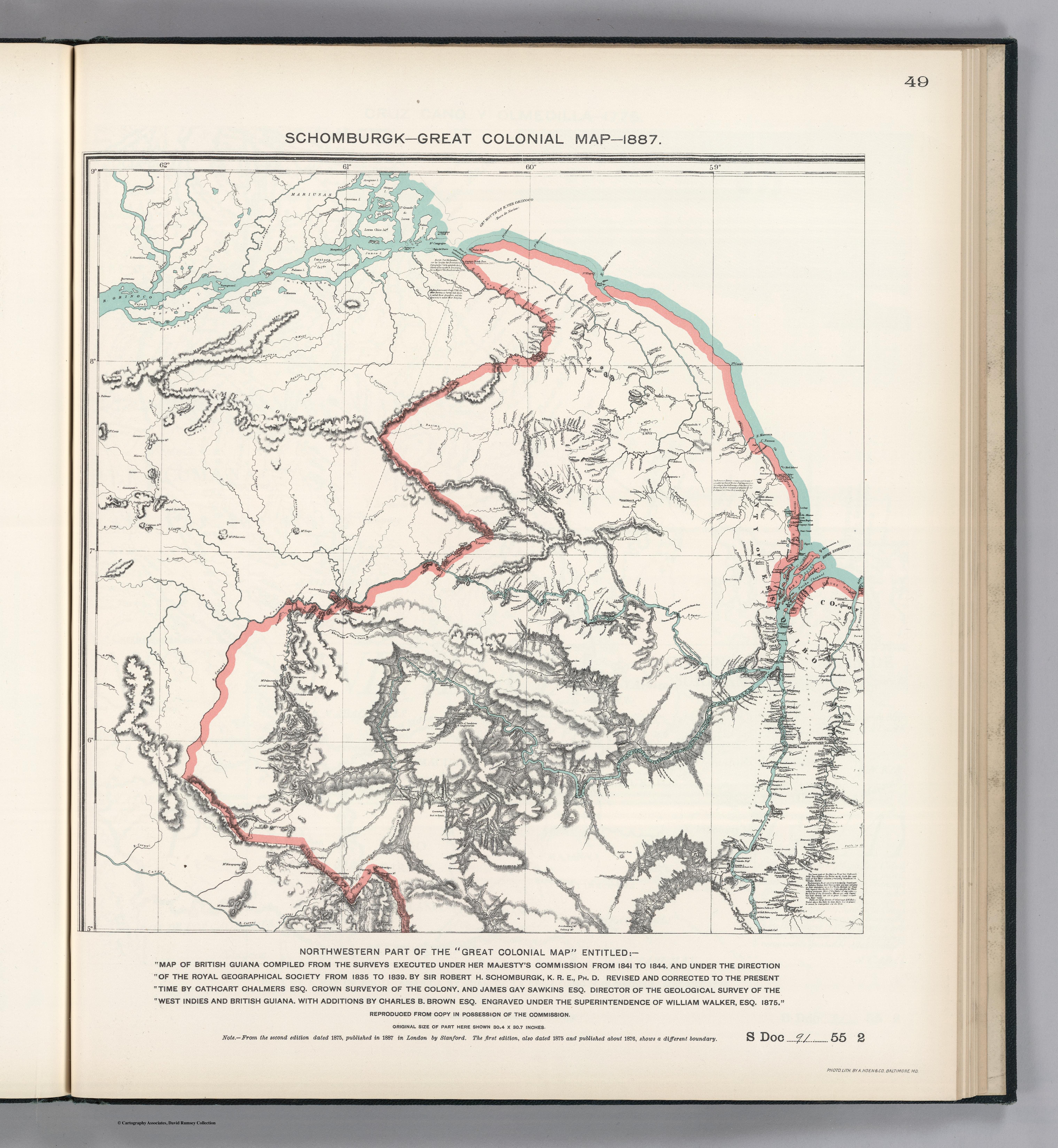
Dispossesions in the Americas

Dispossesions in the Americas

  • Home
  • Explore
  • About
  • Authors
  • Art
  • Bodies
  • Curricula
  • Cultural Heritage
  • Maps
  • Territories
Back to Explore
Map 1875

NORTHWEST PART OF THE "GREAT COLONIAL MAP"

  • SCHOMBURGK;K.R.E.;ET AL.

Published: 1875

  • Download Image

Peoples

  • MARIUSA

Citation

Schomburgk;Robert H.;James Gay Sawkins;and Charles B. Brown. Part of the Great Colonial Map. Map. Washington D.C.: United States of America;1875. Accessed October 23;2022. https://www.davidrumsey.com/luna/servlet/detail/RUMSEY~8~1~204023~3001768:Facsimile--Part-of-the-Great-Coloni?sort=pub_list_no_initialsort%2Cpub_date%2Cpub_list_no%2Cseries_no#.

  • Download Image

Reading in Spanish

Map 1875

NORTHWEST PART OF THE "GREAT COLONIAL MAP"

  • SCHOMBURGK;K.R.E.;ET AL.

Published: 1875

  • Download Image
  • Download Image

Related Content

MAP OF NEW GRANADA

MAP OF NEW GRANADA

Map 1864
SKETCH MAP OF BRITISH GUIANA

SKETCH MAP OF BRITISH GUIANA

Map 1835 - 1839
MAP 4. DISTRIBUTION OF ETHNIC GROUPS IN THE ORIENTE ON THE EVE OF SPANISH CONQUEST

MAP 4. DISTRIBUTION OF ETHNIC GROUPS IN THE ORIENTE ON THE EVE OF SPANISH CONQUEST

Map 1535
Carte de la Republique du Paraguay : (Cours du Parana et du Paraguay) : (Amerique Méridionale)

Carte de la Republique du Paraguay : (Cours du Parana et du Paraguay) : (Amerique Méridionale)

Map 1857 - 1859
The Mexican Countryside under Spanish Rule (Circa 1580), Relacion Geográfica de Oaxtepec

The Mexican Countryside under Spanish Rule (Circa 1580), Relacion Geográfica de Oaxtepec

Map 1580
PLANO QUE SE ADJUNTA AL PROCESO QUE SIGUEN LOS INDÍGENAS DE LA COMUNIDAD DE COLAMBO;LOJA CONTRA DIEGO BRICINO A QUIEN ACUSAN DE HABERSE APROPIADO DE LAS TIERRAS DE ESTA COMUNIDAD

PLANO QUE SE ADJUNTA AL PROCESO QUE SIGUEN LOS INDÍGENAS DE LA COMUNIDAD DE COLAMBO;LOJA CONTRA DIEGO BRICINO A QUIEN ACUSAN DE HABERSE APROPIADO DE LAS TIERRAS DE ESTA COMUNIDAD

Map 1697
Eastern Nicaragua

Eastern Nicaragua

Map 1928
Totocanapan: Approximate Extension in Ancient and Recent Times

Totocanapan: Approximate Extension in Ancient and Recent Times

Map 1940

Dispossessions in the Americas

A project by

University of Pennsylvania

Copyright 2024

With support from

Mellon Foundation

Site design & development

Element 84

Art Credits

Schomburgk;Robert H.;James Gay Sawkins;and Charles B. Brown. Part of the Great Colonial Map. Map. Washington D.C.: United States of America;1875. Accessed October 23;2022. https://www.davidrumsey.com/luna/servlet/detail/RUMSEY~8~1~204023~3001768:Facsimile--Part-of-the-Great-Coloni?sort=pub_list_no_initialsort%2Cpub_date%2Cpub_list_no%2Cseries_no#.

Site Pages

  • Home
  • Explore
  • About
  • Authors
  • Art
  • Bodies
  • Curricula
  • Cultural Heritage
  • Maps
  • Territories