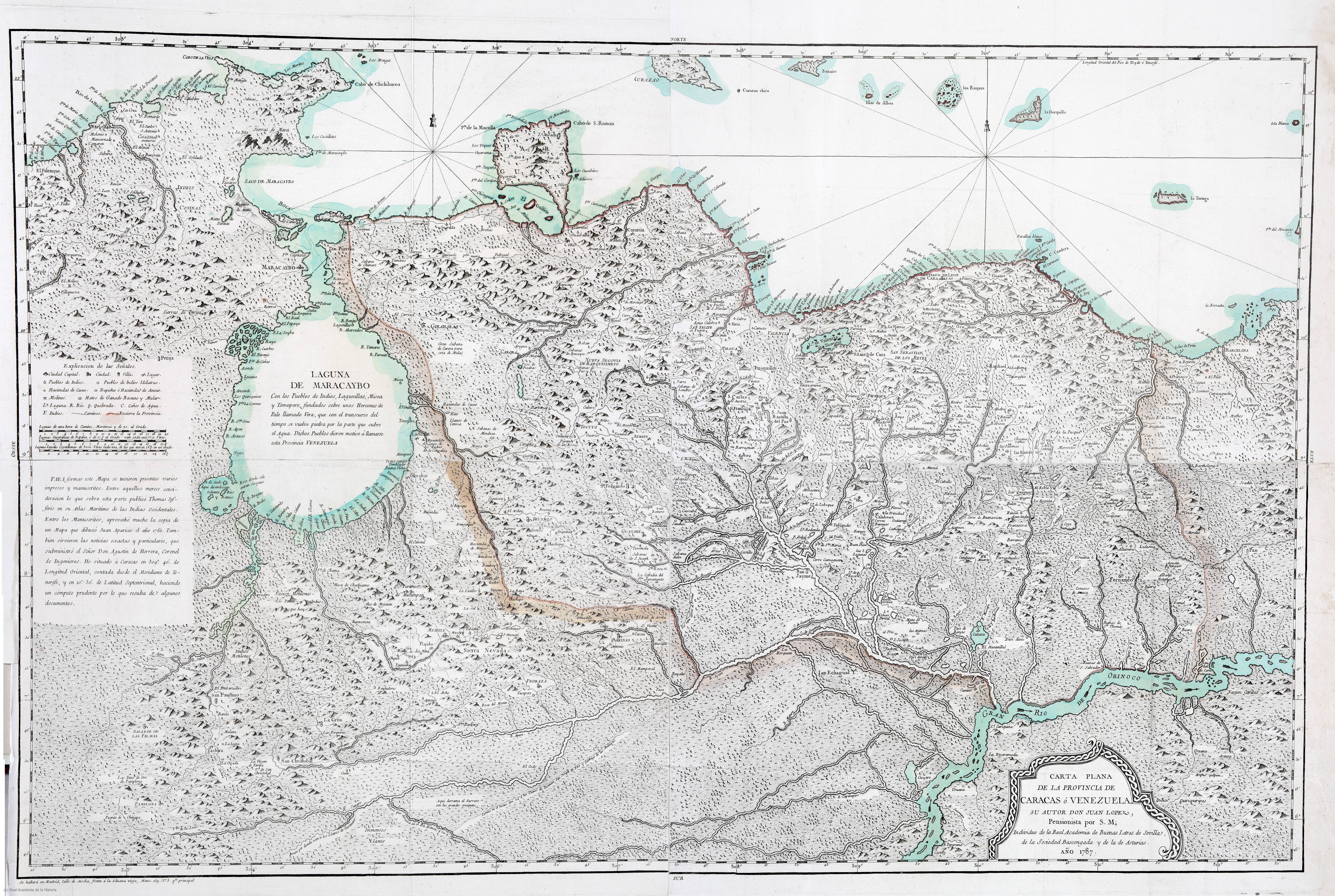
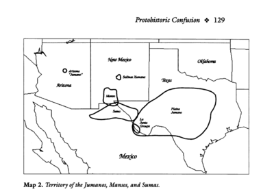
Dispossesions in the Americas

Dispossesions in the Americas

  • Home
  • Explore
  • About
  • Authors
  • Art
  • Bodies
  • Curricula
  • Cultural Heritage
  • Maps
  • Territories
Back to Explore
Map 1787

CARTA PLANA DE LA PROVINCIA DE CARACAS Ó VENEZUELA

  • LOPEZ;JUAN

Published: 1787

  • Download Image

Peoples

  • BARI
  • JIRAJARA
  • ACHAGUA
  • QUIRIQUIRES
  • QUIRIQUIRIPAS
  • CARIBES
  • ZAPARA
  • INDIOS COSINAS

Citation

Lopez;Juan. Carta Plana de la provincia de Caracas ó Venezuela. Map. Madrid;1787. Accessed August 21;2022. https://bvpb.mcu.es/es/catalogo_imagenes/grupo.do?path=155585.

  • Download Image

Reading in Spanish

Map 1787

CARTA PLANA DE LA PROVINCIA DE CARACAS Ó VENEZUELA

  • LOPEZ;JUAN

Published: 1787

  • Download Image
  • Download Image

Reading in Portuguese

Map 1787

CARTA PLANA DE LA PROVINCIA DE CARACAS Ó VENEZUELA

  • LOPEZ;JUAN

Published: 1787

  • Download Image

Peoples

  • BARI
  • JIRAJARA
  • ACHAGUA
  • QUIRIQUIRES
  • QUIRIQUIRIPAS
  • CARIBES
  • ZAPARA
  • INDIOS COSINAS

Citation

Lopez;Juan. Carta Plana de la provincia de Caracas ó Venezuela. Map. Madrid;1787. Accessed August 21;2022. https://bvpb.mcu.es/es/catalogo_imagenes/grupo.do?path=155585.

  • Download Image

Related Content

PUEBLO OLUTECO

PUEBLO OLUTECO

Map 2020
Territory of the Jumanos, Mansos, and Sumas

Territory of the Jumanos, Mansos, and Sumas

Map 1997
Maká

Maká

Map 2001
Santa Elena and Pueblo Viejo

Santa Elena and Pueblo Viejo

Map 1997
El área cultural de los tukano occidentales

El área cultural de los tukano occidentales

Map 1997
Meditação da ferida 
ou a escola das facas [Meditation on the Wound
or the School of Knives](Nakoada version), 2022

Meditação da ferida ou a escola das facas [Meditation on the Wound or the School of Knives](Nakoada version), 2022

Artwork
Carte de l'Isthme de Panama depuis Panama jusques à la Riviere de Nata du coté du Sud, et depuis Porto Betto, jusques à la Riviere de Codé du coté du Nord

Carte de l'Isthme de Panama depuis Panama jusques à la Riviere de Nata du coté du Sud, et depuis Porto Betto, jusques à la Riviere de Codé du coté du Nord

Map 1686
Native Groups in Northern Baja California

Native Groups in Northern Baja California

Map 1939

Dispossessions in the Americas

A project by

University of Pennsylvania

Copyright 2024

With support from

Mellon Foundation

Site design & development

Element 84

Art Credits

Lopez;Juan. Carta Plana de la provincia de Caracas ó Venezuela. Map. Madrid;1787. Accessed August 21;2022. https://bvpb.mcu.es/es/catalogo_imagenes/grupo.do?path=155585.

Site Pages

  • Home
  • Explore
  • About
  • Authors
  • Art
  • Bodies
  • Curricula
  • Cultural Heritage
  • Maps
  • Territories