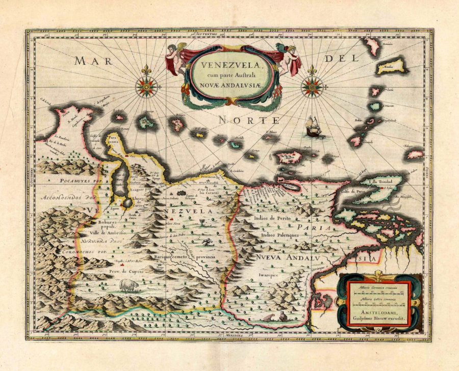
Dispossesions in the Americas

Dispossesions in the Americas

  • Home
  • Explore
  • About
  • Authors
  • Art
  • Bodies
  • Curricula
  • Cultural Heritage
  • Maps
  • Territories
Back to Explore
Map 1630

Venezuela;cum parte Australi Novae Andalusiae

  • BLAEU;WILLEM JANSZOON;ET AL.

Published: 1647

  • Download Image

Peoples

  • PALENQUES
  • KAKETIO
  • ACHAGUA
  • BOBURES
  • COROMOCHOS
  • POCABUYES

Citation

Blaeu;Willem Janszoon;and Joan Blaeu. Venezuela;cum parte Australi Novae Andalusiae. Map. Amsterdam;Netherlands: Blaeu Printing House;1647. Accessed March 13;2022. https://sanderusmaps.com/our-catalogue/antique-maps/america/south-america/old-antique-map-of-venezuela-by-willem-joan-blaeu-26853.

  • Download Image

Reading in Spanish

Map 1630

Venezuela;cum parte Australi Novae Andalusiae

  • BLAEU;WILLEM JANSZOON;ET AL.

Published: 1647

  • Download Image
  • Download Image

Reading in Portuguese

Map 1630

Venezuela;cum parte Australi Novae Andalusiae

  • BLAEU;WILLEM JANSZOON;ET AL.

Published: 1647

  • Download Image

Peoples

  • PALENQUES
  • KAKETIO
  • ACHAGUA
  • BOBURES
  • COROMOCHOS
  • POCABUYES

Citation

Blaeu;Willem Janszoon;and Joan Blaeu. Venezuela;cum parte Australi Novae Andalusiae. Map. Amsterdam;Netherlands: Blaeu Printing House;1647. Accessed March 13;2022. https://sanderusmaps.com/our-catalogue/antique-maps/america/south-america/old-antique-map-of-venezuela-by-willem-joan-blaeu-26853.

  • Download Image

Related Content

LA USURPACIÓN DEL TERRITORIO AYOREO EN PARAGUAY

LA USURPACIÓN DEL TERRITORIO AYOREO EN PARAGUAY

Map 1950 - 2009
Cartografía hispano colonial de Chile

Cartografía hispano colonial de Chile

Map 1500 - 1800
Mapa de las culturas indígenas en vísperas de la conquista española.

Mapa de las culturas indígenas en vísperas de la conquista española.

Map 1650 - 1750
Subdelegaciones de la Nueva España en 1800

Subdelegaciones de la Nueva España en 1800

Map 1800
PUEBLO KUKAMA KUKAMIRIA

PUEBLO KUKAMA KUKAMIRIA

Map 2021
Le Paraguay

Le Paraguay

Map 1600 - 1700
MIDWEST HIGHLANDS OF GUATEMALA, POPULATION ESTIMATES AS OF 1937

MIDWEST HIGHLANDS OF GUATEMALA, POPULATION ESTIMATES AS OF 1937

Map 1937
Territorio Mapuche hacia 1540

Territorio Mapuche hacia 1540

Map 1540

Dispossessions in the Americas

A project by

University of Pennsylvania

Copyright 2024

With support from

Mellon Foundation

Site design & development

Element 84

Art Credits

Blaeu;Willem Janszoon;and Joan Blaeu. Venezuela;cum parte Australi Novae Andalusiae. Map. Amsterdam;Netherlands: Blaeu Printing House;1647. Accessed March 13;2022. https://sanderusmaps.com/our-catalogue/antique-maps/america/south-america/old-antique-map-of-venezuela-by-willem-joan-blaeu-26853.

Site Pages

  • Home
  • Explore
  • About
  • Authors
  • Art
  • Bodies
  • Curricula
  • Cultural Heritage
  • Maps
  • Territories