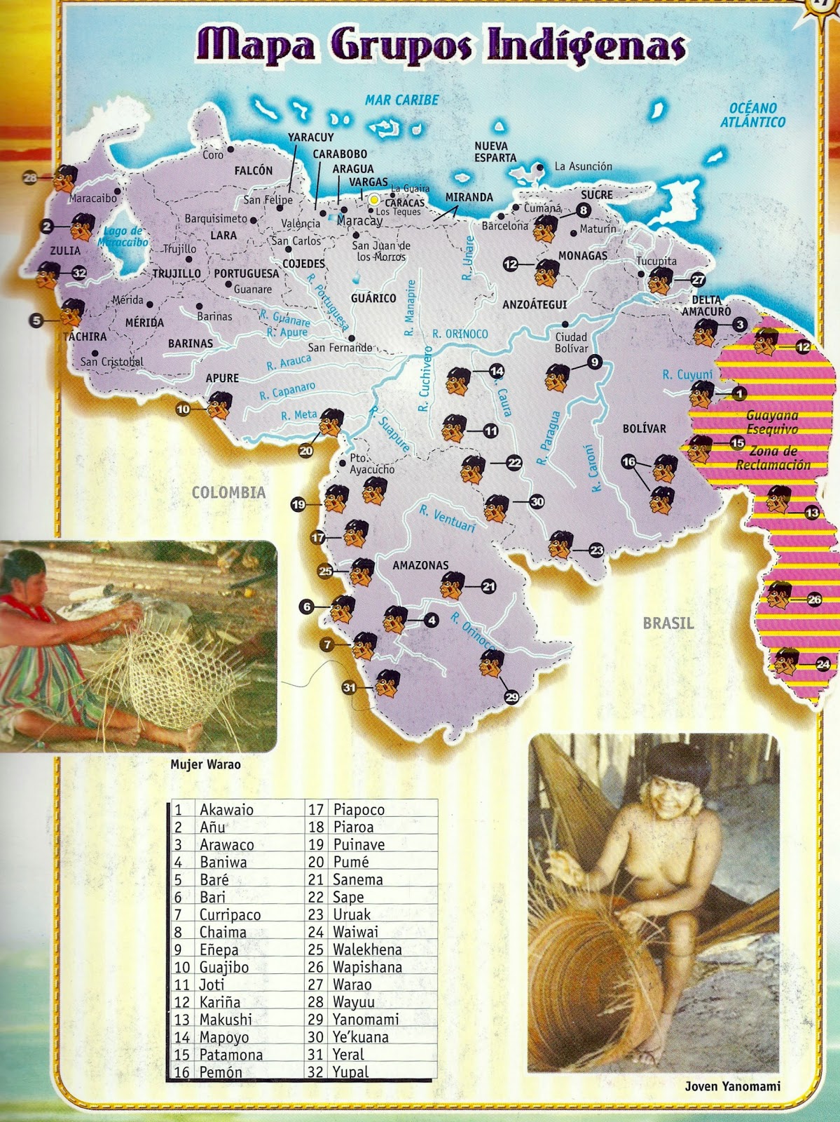
Dispossesions in the Americas

Dispossesions in the Americas

  • Home
  • Explore
  • About
  • Authors
  • Art
  • Bodies
  • Curricula
  • Cultural Heritage
  • Maps
  • Territories
Back to Explore
Map 2011

Mapa Grupos Indígenas

    Published: 2011

    • Download Image

    Peoples

    • AKAWAIO
    • ANUU
    • ARAWAK
    • BARE
    • BARI
    • CHAIMA
    • ENEPA
    • HOTI
    • JIVI
    • KALINA
    • MAKUSHI
    • MAPOYO
    • PEMON
    • PIAROA
    • PUINAVE
    • SANEMA
    • SAPE
    • SOTO
    • TSASE
    • URUAK
    • WAKUENAI
    • WALIMANAI
    • WAPISHANA
    • WARAO
    • WAYUU
    • YANOMAMI
    • YARURO
    • YERAL
    • PATAMONA
    • WAIWAI
    • WALEKHENA
    • YUPAL

    Citation

    "Venezuela: los pueblos indígenas denuncian aún más obstáculos para el reconocimiento de sus derechos sobre la tierra." La Guayana Esequiba. Last modified April 21;2011. Accessed March 13;2022. http://laguayanaesequiba.blogspot.com/2011/04/venezuela-los-pueblos-indigenas.html.

    • Download Image

    Reading in Spanish

    Map 2011

    Mapa Grupos Indígenas

      Published: 2011

      • Download Image
      • Download Image

      Related Content

      Descripciones geograficas de muchas tierras y mares del Norte y Sur en las Indias

      Descripciones geograficas de muchas tierras y mares del Norte y Sur en las Indias

      Map 1613 - 1615
      Guatemala Maya Ethnicity Year 2018

      Guatemala Maya Ethnicity Year 2018

      Map 2000
      Indigenous Peoples of Nicaragua: Showing traditional lands of seven currently recognized people and groups.

      Indigenous Peoples of Nicaragua: Showing traditional lands of seven currently recognized people and groups.

      Map 2022
      PROVINCIA DE SANTA CRUZ

      PROVINCIA DE SANTA CRUZ

      Map 1873
      Indian Languages, Late 16th Century, (According to Ponce and Viana).

      Indian Languages, Late 16th Century, (According to Ponce and Viana).

      Map 1500
      PROVINCIAS DEL QULLASUYU BAJO DOMINIO INCA PRINCIPIOS DEL SIGLO XVI

      PROVINCIAS DEL QULLASUYU BAJO DOMINIO INCA PRINCIPIOS DEL SIGLO XVI

      Map 1530 - 1540
      BRAZIL

      BRAZIL

      Map 1855
      Location of Nahuat Area on Gulf Coast Plain

      Location of Nahuat Area on Gulf Coast Plain

      Map 1969

      Dispossessions in the Americas

      A project by

      University of Pennsylvania

      Copyright 2024

      With support from

      Mellon Foundation

      Site design & development

      Element 84

      Art Credits

      “Venezuela: los pueblos indígenas denuncian aún más obstáculos para el reconocimiento de sus derechos sobre la tierra.” La Guayana Esequiba. Last modified April 21;2011. Accessed March 13;2022. http://laguayanaesequiba.blogspot.com/2011/04/venezuela-los-pueblos-indigenas.html.

      Site Pages

      • Home
      • Explore
      • About
      • Authors
      • Art
      • Bodies
      • Curricula
      • Cultural Heritage
      • Maps
      • Territories