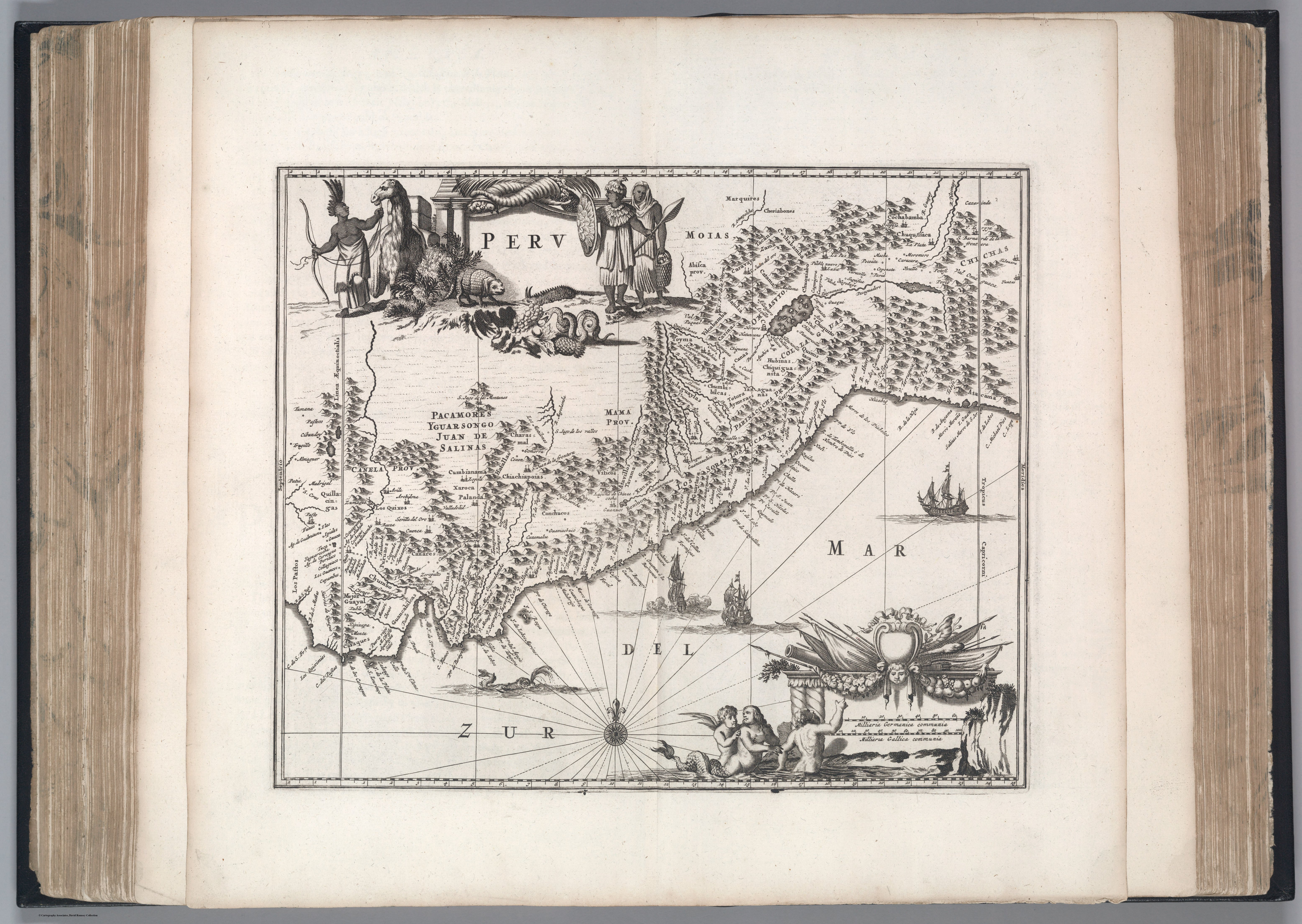
Dispossesions in the Americas

Dispossesions in the Americas

  • Home
  • Explore
  • About
  • Authors
  • Art
  • Bodies
  • Curricula
  • Cultural Heritage
  • Maps
  • Territories
Back to Explore
Map 1671

Peru

  • John Ogilby

Published: 1671

  • Download Image

Peoples

  • CANAS
  • CHERIABONES
  • MOIAS
  • CANCHES
  • AYMERAES
  • VITICOS
  • ATAVILLOS
  • MOTIBONES
  • CONCHUCOS
  • PAFTOS

Citation

Ogilby, J. (Cartographer). (1671). Peru [Map]. David Rumsey. https://www.davidrumsey.com/luna/servlet/detail/RUMSEY~8~1~292973~90066923:Peru-?sort=Pub_List_No_InitialSort&qvq=w4s:/where%2FPeru;q:John%20Ogilby;sort:Pub_List_No_InitialSort;lc:RUMSEY~8~1&mi=0&trs=1

  • Download Image

Reading in Spanish

Map 1671

Peru

  • John Ogilby

Published: 1671

  • Download Image
  • Download Image

Reading in Portuguese

Map 1671

Peru

  • John Ogilby

Published: 1671

  • Download Image

Peoples

  • CANAS
  • CHERIABONES
  • MOIAS
  • CANCHES
  • AYMERAES
  • VITICOS
  • ATAVILLOS
  • MOTIBONES
  • CONCHUCOS
  • PAFTOS

Citation

Ogilby, J. (Cartographer). (1671). Peru [Map]. David Rumsey. https://www.davidrumsey.com/luna/servlet/detail/RUMSEY~8~1~292973~90066923:Peru-?sort=Pub_List_No_InitialSort&qvq=w4s:/where%2FPeru;q:John%20Ogilby;sort:Pub_List_No_InitialSort;lc:RUMSEY~8~1&mi=0&trs=1

  • Download Image

Related Content

FDRC KLEMM

FDRC KLEMM

Artwork
MAPPA da Provincia DE SAN PEDRO

MAPPA da Provincia DE SAN PEDRO

Map 1839
Gulf of Amapall

Gulf of Amapall

Map 1683 - 1685
Pueblos indígenas en el Perú amazónico

Pueblos indígenas en el Perú amazónico

Map 2009
Territorios donde viven descendientes de indígenas

Territorios donde viven descendientes de indígenas

Map 2010 - 2020
Carte des Embouchûres des Rivières d'Ouyapoque et d'Aprouague et de la distance que contient le chemin parterre qu'a fait Monsieur de Régis au mois d'août 1738 .

Carte des Embouchûres des Rivières d'Ouyapoque et d'Aprouague et de la distance que contient le chemin parterre qu'a fait Monsieur de Régis au mois d'août 1738 .

Map 1738
CARTE DU MIXTECAPAN

CARTE DU MIXTECAPAN

Map 1906
PUEBLO PA IPAI

PUEBLO PA IPAI

Map 2020

Dispossessions in the Americas

A project by

University of Pennsylvania

Copyright 2024

With support from

Mellon Foundation

Site design & development

Element 84

Art Credits

Ogilby, J. (Cartographer). (1671). Peru [Map]. David Rumsey. https://www.davidrumsey.com/luna/servlet/detail/RUMSEY~8~1~292973~90066923:Peru-?sort=Pub_List_No_InitialSort&qvq=w4s:/where%2FPeru;q:John%20Ogilby;sort:Pub_List_No_InitialSort;lc:RUMSEY~8~1&mi=0&trs=1

Site Pages

  • Home
  • Explore
  • About
  • Authors
  • Art
  • Bodies
  • Curricula
  • Cultural Heritage
  • Maps
  • Territories