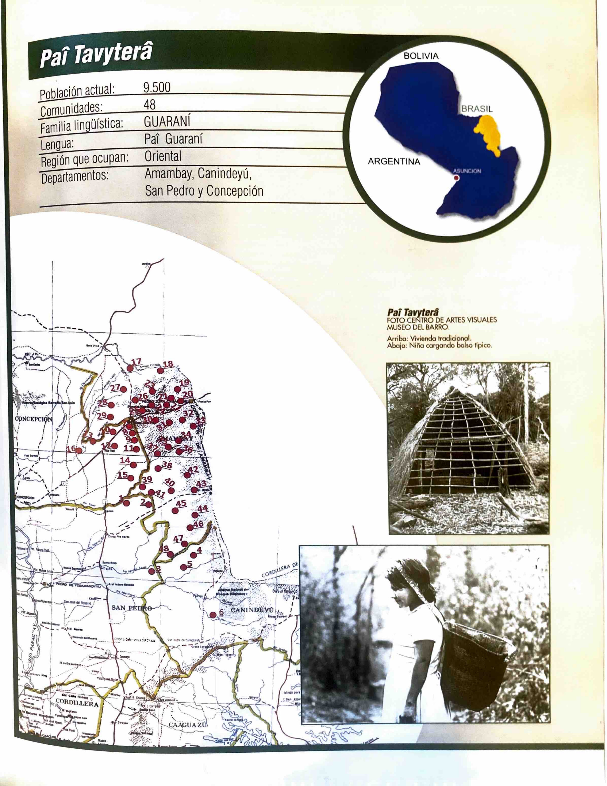
Dispossesions in the Americas

Dispossesions in the Americas

  • Home
  • Explore
  • About
  • Authors
  • Art
  • Bodies
  • Curricula
  • Cultural Heritage
  • Maps
  • Territories
Back to Explore
Map 2001

Paî Tavyterâ

  • ZANARDINI, JOSE, ET AL.

Published: 2001

  • Download Image

Peoples

  • PAI TATYTERA

Citation

Zanardini, José, and Walter Biedermann. Los Indígenas Del Paraguay. 2nd ed. Asunción: ITAIPU Binacional, 2006.

  • Download Image

Reading in Spanish

Map 2001

Paî Tavyterâ

  • ZANARDINI, JOSE, ET AL.

Published: 2001

  • Download Image
  • Download Image

Related Content

AMERIQUE MERIDIONALE: BRESIL AUX PORTUGAIS: CAPITAINERIE DE RIO-IANEIRO

AMERIQUE MERIDIONALE: BRESIL AUX PORTUGAIS: CAPITAINERIE DE RIO-IANEIRO

Map 1757
MAP OF SANTA CRUZ XOXOCOTLÁN

MAP OF SANTA CRUZ XOXOCOTLÁN

Map 1686
Plano de pintura, suplemento del mapa de foxas 53, quaderno
     3, mandado a formar por la junta de temporalidades de salta, y este por el
     protector/partidario del indio, para que el despojo que se ha hecho de los
     pueblos y tierras de los indios

Plano de pintura, suplemento del mapa de foxas 53, quaderno 3, mandado a formar por la junta de temporalidades de salta, y este por el protector/partidario del indio, para que el despojo que se ha hecho de los pueblos y tierras de los indios

Map 1790
Plano general de las montañas orientales del Reino del Peru

Plano general de las montañas orientales del Reino del Peru

Map 1795
Map of Honduras and San Salvador, Central America, Showing the line of the proposed Honduras Interoceanic Railway

Map of Honduras and San Salvador, Central America, Showing the line of the proposed Honduras Interoceanic Railway

Map 1854
States in Guatemala and el Salvador on the Eve of Spanish Conquest.

States in Guatemala and el Salvador on the Eve of Spanish Conquest.

Map 1524
Geografia cultural del Tamaulipas prehispánico

Geografia cultural del Tamaulipas prehispánico

Map -5000 - 599
Sketch of the country from reduction to Buenos Ayres, shewing the movements of B. Genl. Beresford, when he captured that place June 1806. Drawn from memorandums furnished by Capt: Donnelly

Sketch of the country from reduction to Buenos Ayres, shewing the movements of B. Genl. Beresford, when he captured that place June 1806. Drawn from memorandums furnished by Capt: Donnelly

Map 1806

Dispossessions in the Americas

A project by

University of Pennsylvania

Copyright 2024

With support from

Mellon Foundation

Site design & development

Element 84

Art Credits

Zanardini, José, and Walter Biedermann. Los Indígenas Del Paraguay. 2nd ed. Asunción: ITAIPU Binacional, 2006.

Site Pages

  • Home
  • Explore
  • About
  • Authors
  • Art
  • Bodies
  • Curricula
  • Cultural Heritage
  • Maps
  • Territories