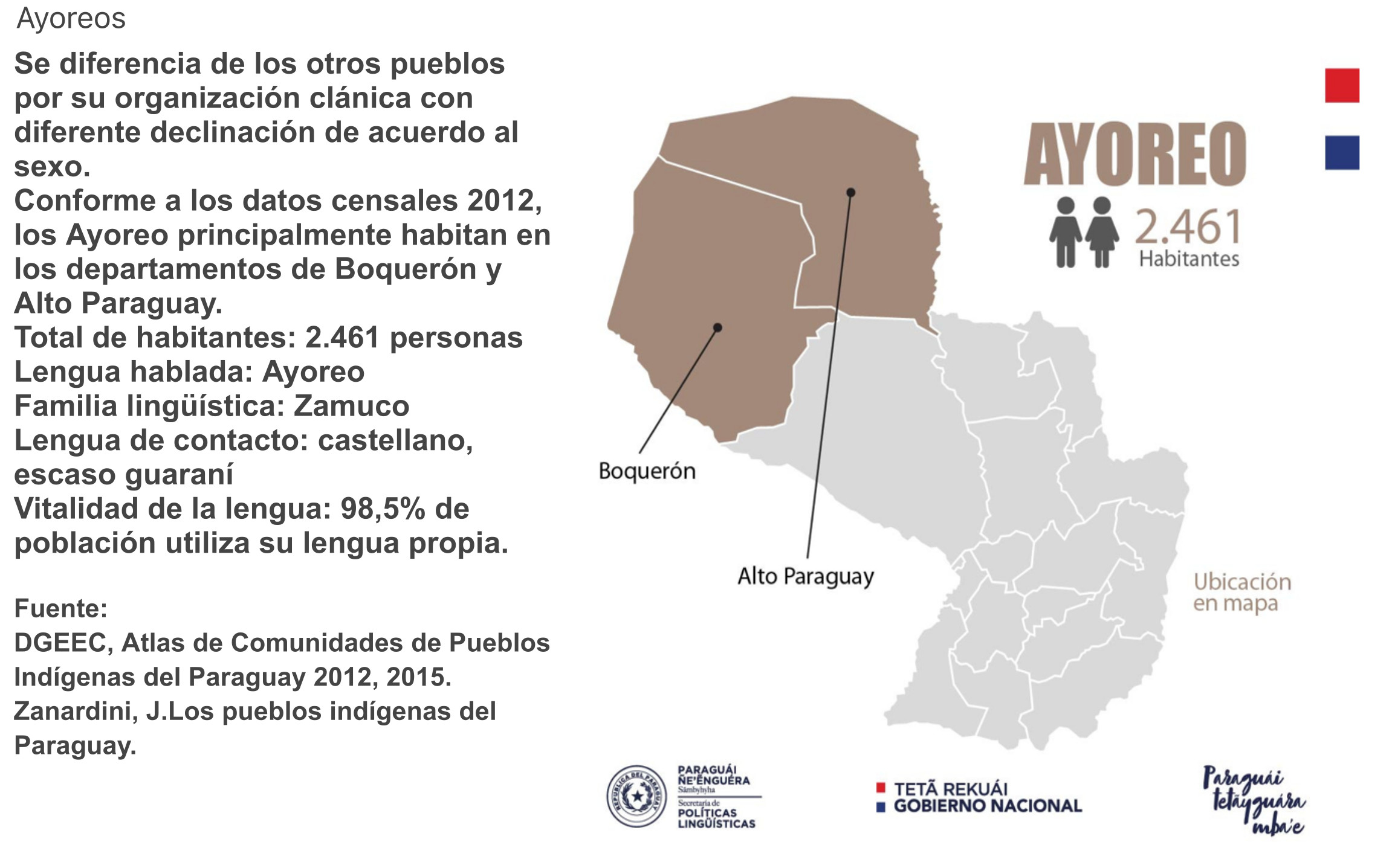
Dispossesions in the Americas

Dispossesions in the Americas

  • Home
  • Explore
  • About
  • Authors
  • Art
  • Bodies
  • Curricula
  • Cultural Heritage
  • Maps
  • Territories
Back to Explore
Map 2020

Comunidades indígenas y Áreas protegidas del Chaco paraguayo

  • MADES 2018, FAPI 2018

Published: 2018

  • Download Image

Peoples

  • COMUNIDADES INDIGENAS

Citation

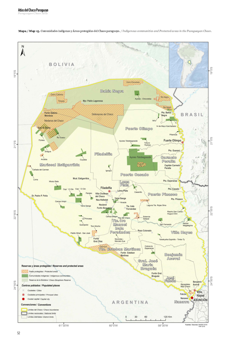
Gill, EA, E. Da Ponte, KP Insfrán, and LR González. "Comunidades indígenas y Áreas protegidas del Chaco paraguayo." Map. In Atlas del Chaco paraguayo, 52. Asunción: World Wildlife Fund, Agencia Aeroespacial Alemana, 2020. Accessed April 8, 2023. https://wwflac.awsassets.panda.org/downloads/atlaschaco_digita_baja.pdf.

  • Download Image

Reading in Spanish

Map 2020

Comunidades indígenas y Áreas protegidas del Chaco paraguayo

  • MADES 2018, FAPI 2018

Published: 2018

  • Download Image
  • Download Image

Related Content

PARAGUAY UND DER NÖRDLICHE THEIL DER ARGENTINISCHEN REPUBLIK

PARAGUAY UND DER NÖRDLICHE THEIL DER ARGENTINISCHEN REPUBLIK

Map 1853 - 56
LE BRESIL, dont la Coste est posse dée par les portugais et divisée en Quatorze Capitanieries.

LE BRESIL, dont la Coste est posse dée par les portugais et divisée en Quatorze Capitanieries.

Map 1656
Carte 6: Migrations des Tupi au nord de l'Amazones (XVIe et XVIIe siècles)

Carte 6: Migrations des Tupi au nord de l'Amazones (XVIe et XVIIe siècles)

Map 1500 - 1699
Present Distribution of the Otomi Family

Present Distribution of the Otomi Family

Map 1969
PAA. Pan American Flight Map. New York and Caribbean.

PAA. Pan American Flight Map. New York and Caribbean.

Map 1508 - 1783
Cited Toldería Locations, 1750-1806

Cited Toldería Locations, 1750-1806

Map 1750 - 1806
Grupos étnicos al contacto con Humboldt (1800-1810)

Grupos étnicos al contacto con Humboldt (1800-1810)

Map 1800 - 1810
AYOREO

AYOREO

Map 2015

Dispossessions in the Americas

A project by

University of Pennsylvania

Copyright 2024

With support from

Mellon Foundation

Site design & development

Element 84

Art Credits

Gill, EA, E. Da Ponte, KP Insfrán, and LR González. “Comunidades indígenas y Áreas protegidas del Chaco paraguayo.” Map. In Atlas del Chaco paraguayo, 52. Asunción: World Wildlife Fund, Agencia Aeroespacial Alemana, 2020. Accessed April 8, 2023. https://wwflac.awsassets.panda.org/downloads/atlaschaco_digita_baja.pdf.

Site Pages

  • Home
  • Explore
  • About
  • Authors
  • Art
  • Bodies
  • Curricula
  • Cultural Heritage
  • Maps
  • Territories