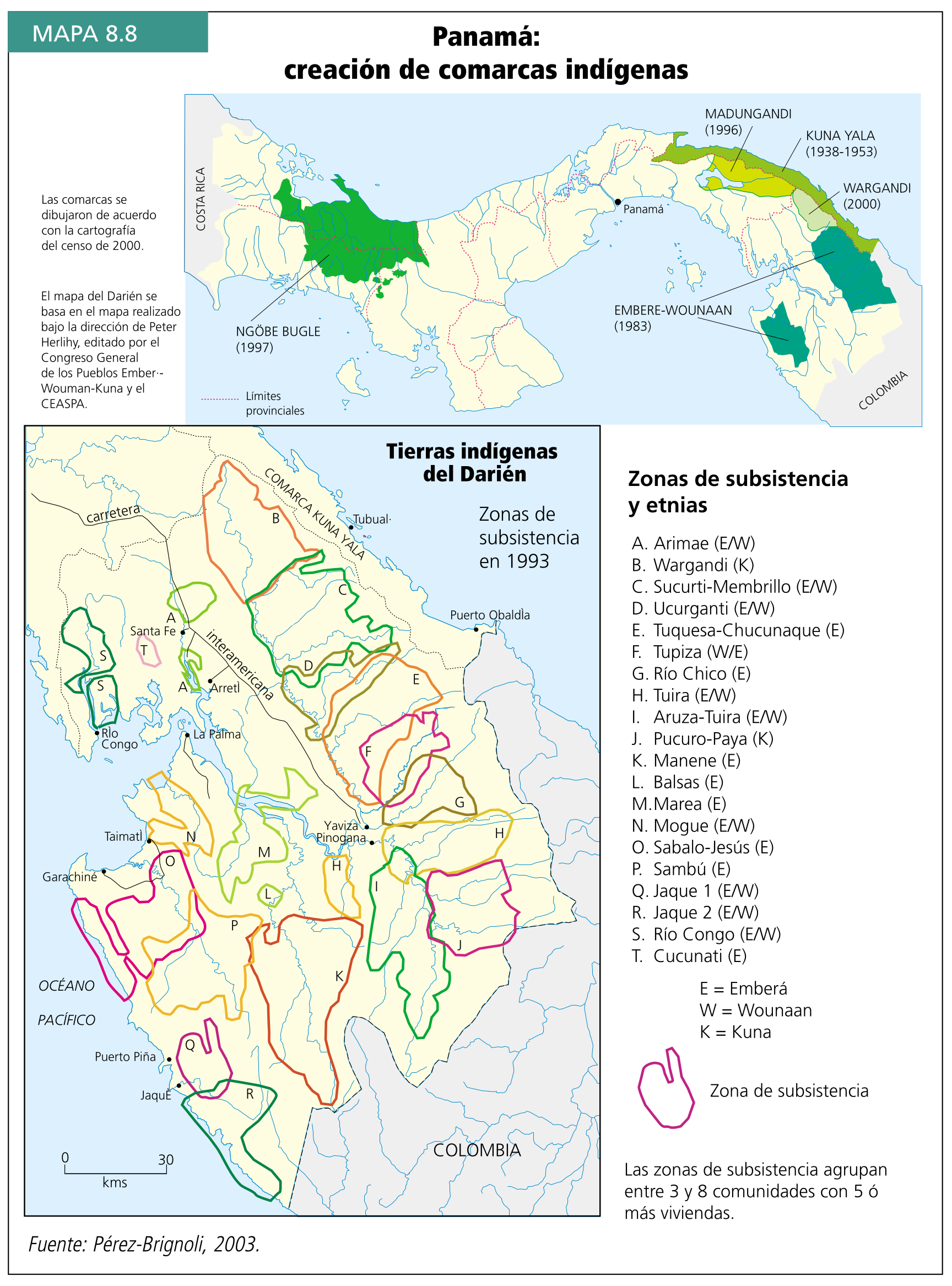
Dispossesions in the Americas

Dispossesions in the Americas

  • Home
  • Explore
  • About
  • Authors
  • Art
  • Bodies
  • Curricula
  • Cultural Heritage
  • Maps
  • Territories
Back to Explore
Map 2000

Panamá: creación de comarcas indígenas

  • PEREZ-BRIGNOLI

Published: 2003

  • Download Image

Peoples

  • NGOBE BUGLE
  • EMBERA
  • WOUNAAN
  • KUNA

Citation

PEREZ-BRIGNOLI. Gurdián, Galio, and Programa Estado de la Nación. El desafío de la multiculturalidad. Edited by Arodys Robles and Carlos Francisco Echeverría. 2003. Accessed May 8, 2022. https://repositorio.conare.ac.cr/handle/20.500.12337/715?show=full.

  • Download Image

Reading in Spanish

Map 2000

Panamá: creación de comarcas indígenas

  • PEREZ-BRIGNOLI

Published: 2003

  • Download Image
  • Download Image

Reading in Portuguese

Map 2000

Panamá: creación de comarcas indígenas

  • PEREZ-BRIGNOLI

Published: 2003

  • Download Image

Peoples

  • NGOBE BUGLE
  • EMBERA
  • WOUNAAN
  • KUNA

Citation

PEREZ-BRIGNOLI. Gurdián, Galio, and Programa Estado de la Nación. El desafío de la multiculturalidad. Edited by Arodys Robles and Carlos Francisco Echeverría. 2003. Accessed May 8, 2022. https://repositorio.conare.ac.cr/handle/20.500.12337/715?show=full.

  • Download Image

Related Content

CARTE DU BRÉSIL

CARTE DU BRÉSIL

Map 1836
A Map of BRASIL and Part of LA PLATA

A Map of BRASIL and Part of LA PLATA

Map 1717
PUEBLO PUREPECHA

PUEBLO PUREPECHA

Map 2020
CARTE DE LA CAPITAINERIE GENERALE DE CARACAS Comprenant les Provinces de Venezuela;Maracaibo;Varinas;Cumana;la Guiane;et Isle de la Margeurite;Pour servir au Voyage a la partie oriental de la Terre Ferme dans l'Amerique Meridionale

CARTE DE LA CAPITAINERIE GENERALE DE CARACAS Comprenant les Provinces de Venezuela;Maracaibo;Varinas;Cumana;la Guiane;et Isle de la Margeurite;Pour servir au Voyage a la partie oriental de la Terre Ferme dans l'Amerique Meridionale

Map 1801 - 1805
Amerique Meridionale

Amerique Meridionale

Map 1600 - 1699
CROQUIS DE LOS RÍOS NAPO Y PUTUMAYO Según datos traídos por el Coronel D. PEDRO PORTILLO

CROQUIS DE LOS RÍOS NAPO Y PUTUMAYO Según datos traídos por el Coronel D. PEDRO PORTILLO

Map 1905
FIGURE 26.1. MAP OF COASTAL ECUADOR SHOWING THE PRINCIPAL COASTAL PREHISPANIC CULTURES AND SITES

FIGURE 26.1. MAP OF COASTAL ECUADOR SHOWING THE PRINCIPAL COASTAL PREHISPANIC CULTURES AND SITES

Map 1500
TERRITORIO DEL SEÑORÍO  AYMARA DE LOS KILLAKAS A PRINCIPIOS DEL SIGLO XVI

TERRITORIO DEL SEÑORÍO AYMARA DE LOS KILLAKAS A PRINCIPIOS DEL SIGLO XVI

Map 1500 - 1530

Dispossessions in the Americas

A project by

University of Pennsylvania

Copyright 2024

With support from

Mellon Foundation

Site design & development

Element 84

Art Credits

PEREZ-BRIGNOLI. Gurdián, Galio, and Programa Estado de la Nación. El desafío de la multiculturalidad. Edited by Arodys Robles and Carlos Francisco Echeverría. 2003. Accessed May 8, 2022. https://repositorio.conare.ac.cr/handle/20.500.12337/715?show=full.

Site Pages

  • Home
  • Explore
  • About
  • Authors
  • Art
  • Bodies
  • Curricula
  • Cultural Heritage
  • Maps
  • Territories