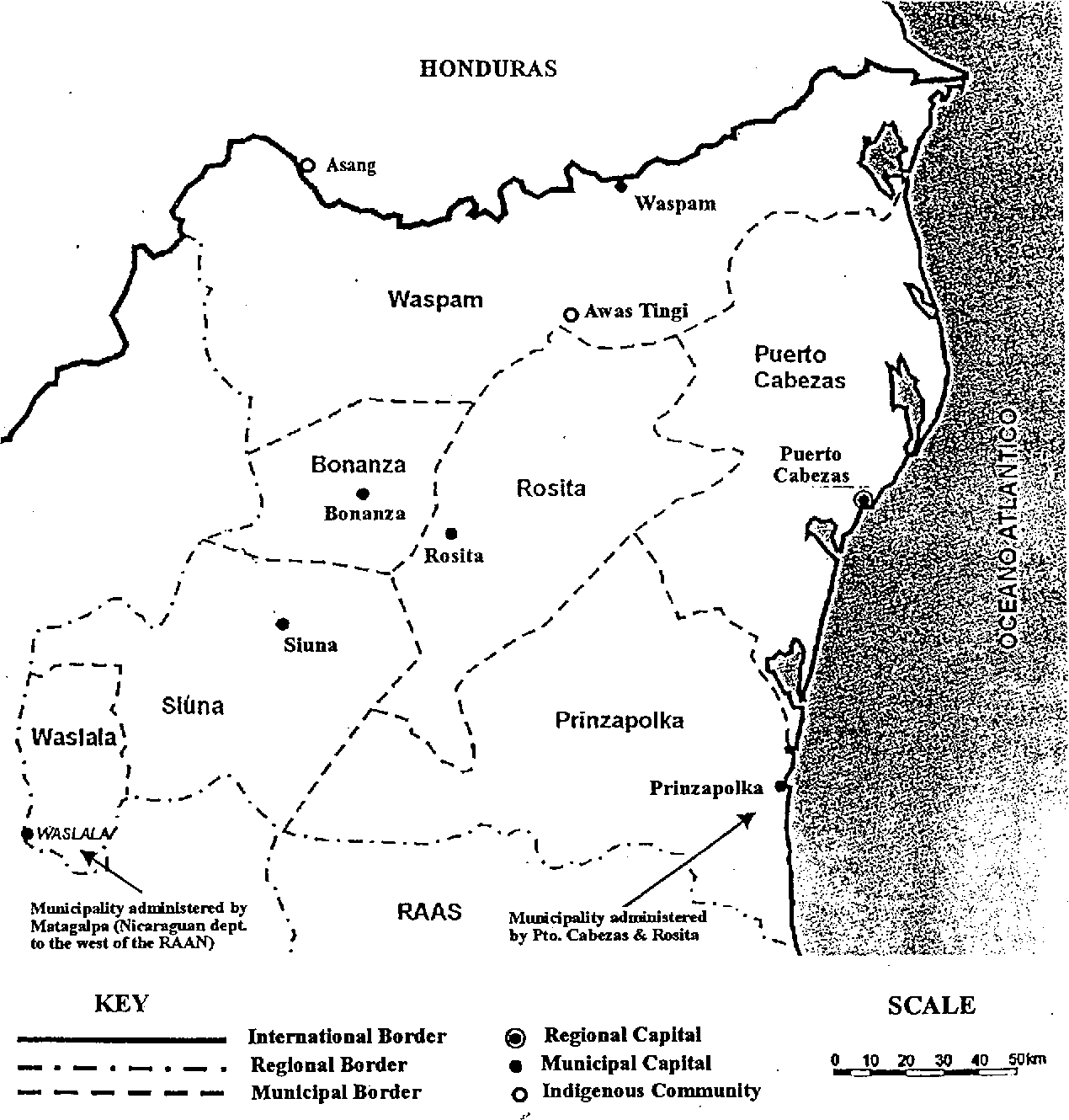
Dispossesions in the Americas

Dispossesions in the Americas

  • Home
  • Explore
  • About
  • Authors
  • Art
  • Bodies
  • Curricula
  • Cultural Heritage
  • Maps
  • Territories
Back to Explore
Map 1900

Map of the North Atlantic Autonomous Region (RAAN);Northeastern Nicaragua.

  • CADDY;EMMA

Published: 1998

  • Download Image

Peoples

  • ASANG
  • AWAS
  • TINGI

Citation

Fig 4. Map of the North Atlantic Autonomous Region (RAAN);Northeastern Nicaragua. Caddy;Emma. 1998. "Indigenous perspectives and resource management contexts: the case of northeastern Nicaragua." api. semanticscholar.org/CorpusID:130866240. Accessed July 27 2023. https://www.semanticscholar.org/paper/Indigenous-perspectives-and-resource-management-the-Caddy/fa7fba3ccc0ecdb6562208fda7bbe3cdeb6080ad

  • Download Image

Reading in Spanish

Map 1900

Map of the North Atlantic Autonomous Region (RAAN);Northeastern Nicaragua.

  • CADDY;EMMA

Published: 1998

  • Download Image
  • Download Image

Reading in Portuguese

Map 1900

Map of the North Atlantic Autonomous Region (RAAN);Northeastern Nicaragua.

  • CADDY;EMMA

Published: 1998

  • Download Image

Peoples

  • ASANG
  • AWAS
  • TINGI

Citation

Fig 4. Map of the North Atlantic Autonomous Region (RAAN);Northeastern Nicaragua. Caddy;Emma. 1998. "Indigenous perspectives and resource management contexts: the case of northeastern Nicaragua." api. semanticscholar.org/CorpusID:130866240. Accessed July 27 2023. https://www.semanticscholar.org/paper/Indigenous-perspectives-and-resource-management-the-Caddy/fa7fba3ccc0ecdb6562208fda7bbe3cdeb6080ad

  • Download Image

Related Content

Carte n°7: Limite septentrionale des poissons Paraiba et Pirarucu

Carte n°7: Limite septentrionale des poissons Paraiba et Pirarucu

Map 1740 - 1978
Mapa de la Distribucion de los Idiomas qu se hablan en Guatemala

Mapa de la Distribucion de los Idiomas qu se hablan en Guatemala

Map 1923
Government map of Nicaragua : from the latest surveys ordered by President Patricio Rivas and Genl. William Walker ;executed under the supervision of the Señor Fermín Ferrer;Governor of the Western Department;1856

Government map of Nicaragua : from the latest surveys ordered by President Patricio Rivas and Genl. William Walker ;executed under the supervision of the Señor Fermín Ferrer;Governor of the Western Department;1856

Map 1800 - 1856
República de Nicaragua: uso actual de la tierra;Territorios Indígenas/Afrodescendientes y Areas Protegidas

República de Nicaragua: uso actual de la tierra;Territorios Indígenas/Afrodescendientes y Areas Protegidas

Map 2012
MAPA DE SAN DIEGO XOCOYUCAN

MAPA DE SAN DIEGO XOCOYUCAN

Map 1500 - 1599
PUEBLO MATSÉS

PUEBLO MATSÉS

Map 2021
FAMILIAS LINGUÍSTICAS Y LENGUAS INDÍGENAS. OCTAVA REGION: PENINSULA DE LA GUAJIRA

FAMILIAS LINGUÍSTICAS Y LENGUAS INDÍGENAS. OCTAVA REGION: PENINSULA DE LA GUAJIRA

Map 1989
Revolución Puta [Whore Revolution]

Revolución Puta [Whore Revolution]

Artwork

Dispossessions in the Americas

A project by

University of Pennsylvania

Copyright 2024

With support from

Mellon Foundation

Site design & development

Element 84

Art Credits

Fig 4. Map of the North Atlantic Autonomous Region (RAAN);Northeastern Nicaragua. Caddy;Emma. 1998. “Indigenous perspectives and resource management contexts: the case of northeastern Nicaragua.” api. semanticscholar.org/CorpusID:130866240. Accessed July 27 2023. https://www.semanticscholar.org/paper/Indigenous-perspectives-and-resource-management-the-Caddy/fa7fba3ccc0ecdb6562208fda7bbe3cdeb6080ad

Site Pages

  • Home
  • Explore
  • About
  • Authors
  • Art
  • Bodies
  • Curricula
  • Cultural Heritage
  • Maps
  • Territories