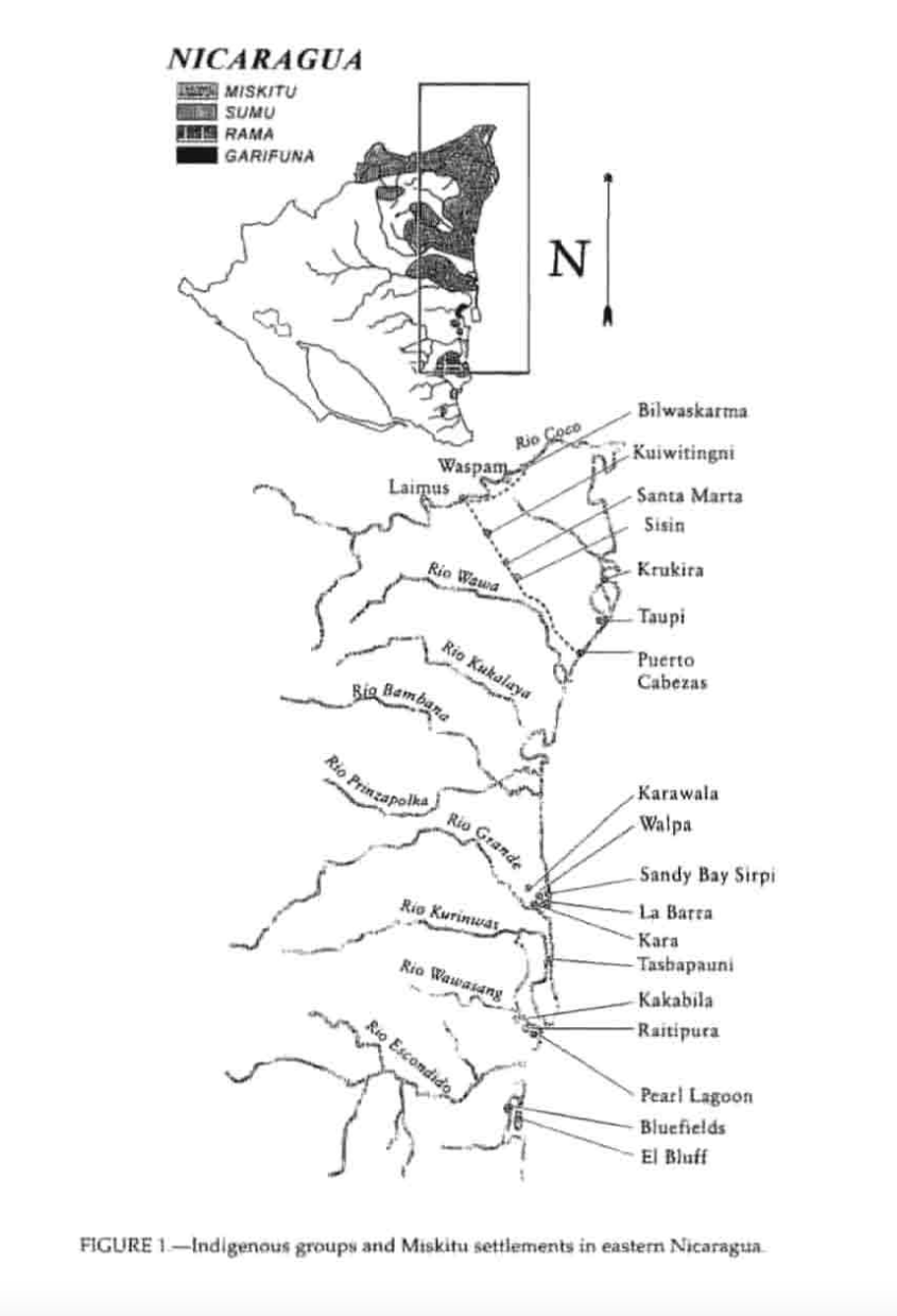
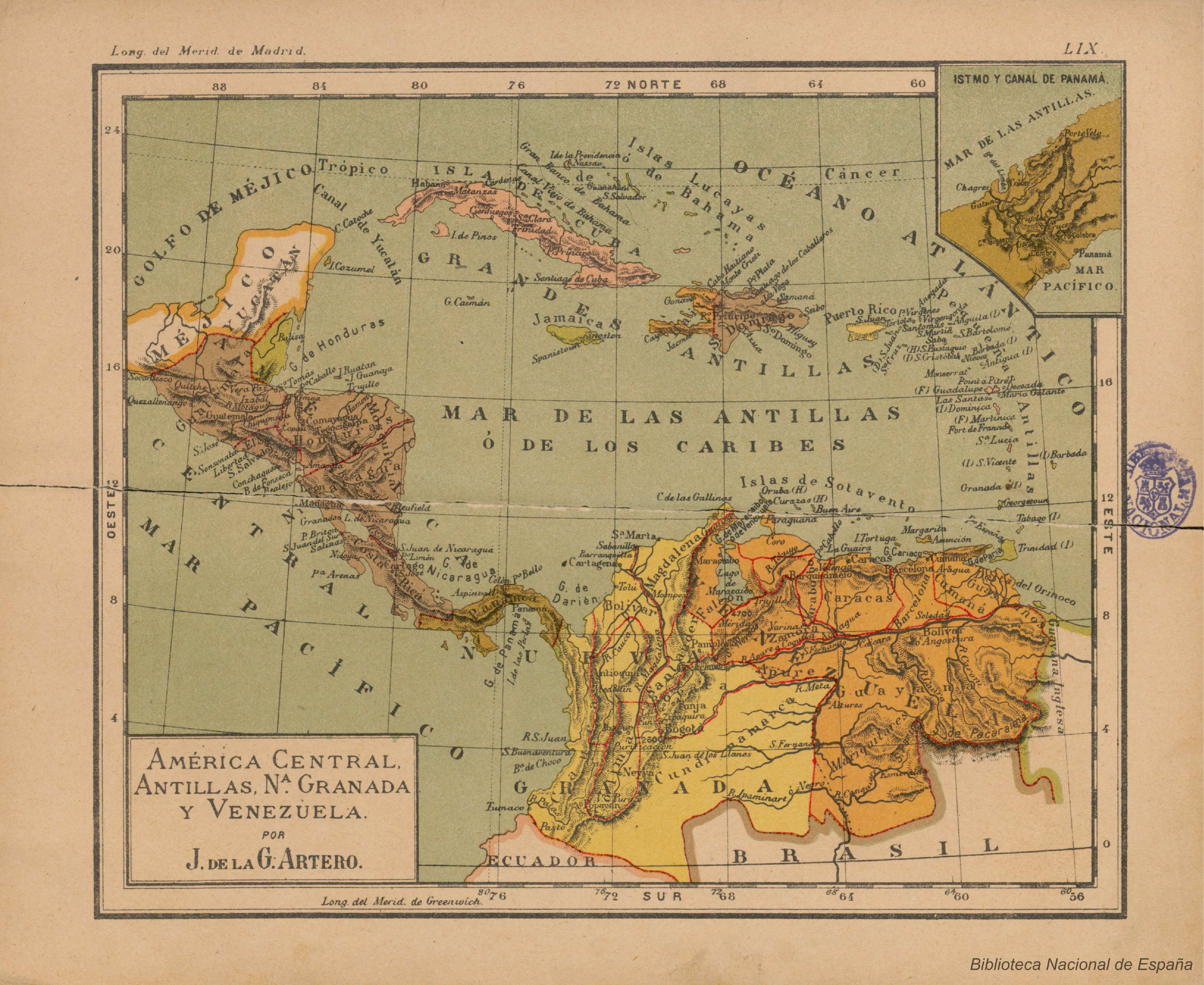
Dispossesions in the Americas

Dispossesions in the Americas

  • Home
  • Explore
  • About
  • Authors
  • Art
  • Bodies
  • Curricula
  • Cultural Heritage
  • Maps
  • Territories
Back to Explore
Map 1990

Indigenous groups and Miskitu settlements in eastern Nicaragua.

  • COE AND ANDERSON

Published: 1997

  • Download Image

Peoples

  • MISKITU
  • SUMU
  • RAMA
  • GARIFUNA

Citation

Figure 1: Indigenous groups and Miskitu settlements in eastern Nicaragua. Coe;Felix and Gregory Anderson.1997."Ethnobotany of the Miskitu in Eastern Nicaragua." Journal of Ethnobotany 17(2):171-214. https://ethnobiology.org/sites/default/files/pdfs/JoE/17-2/CoeAnderson1997.pdf

  • Download Image

Reading in Spanish

Map 1990

Indigenous groups and Miskitu settlements in eastern Nicaragua.

  • COE AND ANDERSON

Published: 1997

  • Download Image
  • Download Image

Reading in Portuguese

Map 1990

Indigenous groups and Miskitu settlements in eastern Nicaragua.

  • COE AND ANDERSON

Published: 1997

  • Download Image

Peoples

  • MISKITU
  • SUMU
  • RAMA
  • GARIFUNA

Citation

Figure 1: Indigenous groups and Miskitu settlements in eastern Nicaragua. Coe;Felix and Gregory Anderson.1997."Ethnobotany of the Miskitu in Eastern Nicaragua." Journal of Ethnobotany 17(2):171-214. https://ethnobiology.org/sites/default/files/pdfs/JoE/17-2/CoeAnderson1997.pdf

  • Download Image

Related Content

The Tawahka: Most important municipios, 2001

The Tawahka: Most important municipios, 2001

Map 2001
Resguardo de los indios de Guateque. Plano en trazo simple de la cuchilla que pretenden los indios. Corresponde al expediente seguido por los indios con Francisco Javier del Castillo, por deslinde de tierras

Resguardo de los indios de Guateque. Plano en trazo simple de la cuchilla que pretenden los indios. Corresponde al expediente seguido por los indios con Francisco Javier del Castillo, por deslinde de tierras

Map 1801
Map of the Inca Empire

Map of the Inca Empire

Map 1490 - 1499
"Territorio Indígena Kekoldi (Bribri)"

"Territorio Indígena Kekoldi (Bribri)"

Map 2010
América central;Antillas;Nª Granada y Venezuela

América central;Antillas;Nª Granada y Venezuela

Map 1911
Distribution of Nahuatl Population, Mexico

Distribution of Nahuatl Population, Mexico

Map 1969
Carte 1. Amapaya/Guyane : données d'ensemble

Carte 1. Amapaya/Guyane : données d'ensemble

Map 1700 - 1900
Mapa de cielo bora [Map of the Bora Sky]

Mapa de cielo bora [Map of the Bora Sky]

Artwork

Dispossessions in the Americas

A project by

University of Pennsylvania

Copyright 2024

With support from

Mellon Foundation

Site design & development

Element 84

Art Credits

Figure 1: Indigenous groups and Miskitu settlements in eastern Nicaragua. Coe;Felix and Gregory Anderson.1997.“Ethnobotany of the Miskitu in Eastern Nicaragua.” Journal of Ethnobotany 17(2):171-214. https://ethnobiology.org/sites/default/files/pdfs/JoE/17-2/CoeAnderson1997.pdf

Site Pages

  • Home
  • Explore
  • About
  • Authors
  • Art
  • Bodies
  • Curricula
  • Cultural Heritage
  • Maps
  • Territories